Hafen San Francisco

Der Hafen San Francisco ist ein großer Seehafen in der Bucht von San Francisco im Nordosten der Stadt. Betreiber ist die City and County of San Francisco.
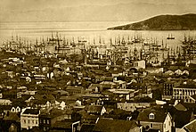
Der Ursprung, Fisherman’s Wharf, entstand Mitte des 19. Jahrhunderts als Fischerhafen und ist heute eine der Haupttouristenattraktionen der Stadt. Noch heute wird dieser als Fischereihafen benutzt. Im Hafen wird heute überwiegend der internationale Seehandel abgewickelt.
Ein Teil eines ehemaligen Hafengebietes ist der San Francisco Maritime National Historical Park.[2]
Anlagen und Einrichtungen
Die Piers sind folgendermaßen nummeriert: Piers nach Norden (ab der Market Street) werden mit ungeraden Zahlen bezeichnet, die Piers nach Süden mit geraden Zahlen.
Ungerade
- Ferry Building and Pier 1 – administration, Mahatma-Gandhi-Statue, Light Cannons
- Pier 1 ½ – water taxi service
- Pier 3 – Offices of Hornblower Cruises
- Pier 5 – Central Embarcadero Piers Historic District
- Pier 7[3]
- Pier 9[4], Liegeplatz der Klamath
- Pier 11[5]
- Pier 13[6]
- Piers 15 and 17 – Exploratorium
- Pier 19[7]
- Pier 23[8]
- Piers 27 and 29 – America’s Cup Park
- Pier 31[9]
- Pier 33 – Alcatraz Ferry
- Pier 35 – Princess Cruises[10]
- Pier 39 – sea lions
- Pier 41 – Fährhafen, Blue & Gold Fleet
- Pier 43[11]
- Pier 43 1/2 – Red & White Fleet
- Pier 45 – Museumsschiffe
Gerade

- Pier 14[12]
- Pier 16[13]
- Pier 18[14]
- Pier 20[15]
- Pier 22 ½[16]
- Pier 24 – Home to Pier 24 Photography
- Pier 26 – Shelton Studios
- Pier 28[17]
- Piers 30 and 32[18]
- Pier 34[19]
- Pier 36[20]
- Pier 38[21]
- Pier 40[22]
- Pier 42[23]
- Pier 48 – neben McCovey Cove
- Pier 50 – ehem. Stützpunkt der Ready Reserve Force[24]
- Pier 52[25]
- Pier 70 – Union Iron Works
- Pier 80[26]
- Pier 90[27]
- Pier 92[28]
- Es gibt westlich des Piers 45 unnummerierte Piers:
- Fisherman’s Wharf
- Hyde Street Pier
- Municipal Pier.
Es besteht eine Schienennetzanbindung für die Union Pacific Railroad und die San Francisco Bay Railroad.[29]
Siehe auch
Weblinks
- Offizielle Website (englisch)
Einzelnachweise
- ↑ Dennis M. Powers: Treasure Ship: The Legend and Legacy of the S.S. Brother Jonathan. Kensington/Citadel Press, New York, New York 2006.
- ↑ San Francisco Maritime Historical Park NPS. Abgerufen am 7. Oktober 2020 (englisch).
- ↑ Pier 7 Photos on the Commons
- ↑ Pier 9 Photos on the Commons
- ↑ Pier 11 Photos on the Commons
- ↑ Pier 13 Photos on the Commons
- ↑ Pier 19 Photos on the Commons
- ↑ Pier 23 Photos on the Commons
- ↑ Pier 31 Photos on the Commons
- ↑ Port of San Francisco, Pier 35. (PDF; 143 kB) Princess.com, archiviert vom Original (nicht mehr online verfügbar) am 20. Oktober 2013; abgerufen am 11. November 2013.
- ↑ Pier 43 Photos on the Commons
- ↑ Pier 14 Photos on the Commons
- ↑ Pier 16 Photos on the Commons
- ↑ Pier 18 Photos on the Commons
- ↑ Pier 20 Photos on the Commons
- ↑ Pier 2 ½ Photos on the Commons
- ↑ Pier 28 Photos on the Commons
- ↑ Piers 30 and 32 Photos on the Commons
- ↑ Pier 34 Photos on the Commons
- ↑ Pier 36 Photos on the Commons
- ↑ Pier 38 Photos on the Commons
- ↑ Pier 40 Photos on the Commons
- ↑ Pier 42 Photos on the Commons
- ↑ Pier 50-RRF. In: navy.memorieshop.com. Abgerufen am 1. August 2019 (englisch).
- ↑ Pier 52 Photos on the Commons
- ↑ Pier 80 Photos on the Commons
- ↑ Pier 90 Photos on the Commons
- ↑ Pier 92 Photos on the Commons
- ↑ Cargo Services. In: sfport.com. Port of San Francisco, abgerufen am 7. Oktober 2020 (englisch).
37.804-122.3999Koordinaten: 37° 48′ 14,4″ N, 122° 23′ 59,6″ W


