Alter Rhein
River in Switzerland
| Alter Rhein | |
|---|---|
 | |
 The Alter Rhein | |
| Location | |
| Countries | Austria and Switzerland |
The Alter Rhein (German pronunciation: [ˈaltɐ ˈʁaɪ̯n] ⓘ; German for Old Rhine) is the old river bed of the Alpine Rhine in St. Gallen and Vorarlberg in the Alpine Rhine Valley, which was cut off when the Rhine was straightened during the 20th century. These cut-off arms have become valuable recreational areas and a nature reserve.
In 1900, the short-cut at Fussach was completed, linking the natural course of the Rhine just upstream of Höchst and St. Margrethen directly to a new outflow into Lake Constance. The old river course downstream of this point, via Rheineck to Altenrhein on the shore of Lake Constance, became known as the Alter Rhein and continues to form the border between Austria and Switzerland. The arm is navigable from the lake to Rheineck, and is used by the Swiss shipping services on the lake to reach landing stages adjacent to Rheineck railway station.
In 1906, the Rheintaler Binnenkanal ("Rhine Valley Inland Canal") was dug, connecting Sennwald to St. Margrethen. In 1923, another short-cut was completed at Diepoldsau, creating another dead branch, also named Alter Rhein.
For the straighening of the Alpine Rhine, the so-called Rhine Regulation, an industrial railway, the International Rhine Regulation Railway, was constructed on both sides of the river, the tracks of which still mostly exist today.
The area between the Old and New Rhine forms the nature reserve Rhine Delta (not to be confused with the Rhine Delta in the Netherlands).
-
 Painting by Max Bach (1841-1914) of the view of Rheineck and the former mouth of the Rhine into Lake Constance
 -
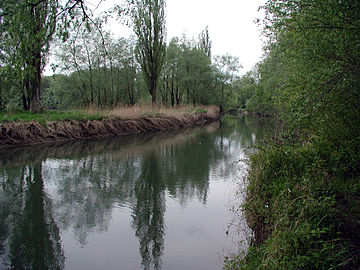 The Alter Rhein near Höchst
 -
 The Alter Rhein at Hohenems, on the border with Diepoldsau


External links
 Media related to Alter Rhein at Wikimedia Commons
- v
- t
- e
Tributaries of the Rhine
- Vorderrhein
- Aua da Russein
- Schmuèr
- Alpine Rhine
- Vorderrhein
- Tamina
- Saar
- Alter Rhein
- Rheintaler Binnenkanal
- Upper Lake Constance
- Goldach
- Aach (Arbon)
- Aach (Romanshorn)
- Lake Rhine
- Grenzbach
- Dorfbach
- Lower Lake Constance
- Anderbach
- High Rhine
- Thur
- Töss
- Glatt
- Aare
- Sissle
- Möhlinbach
- Ergolz
- Birs
- Upper Rhine
- Birsig
- Ill
- Moder
- Sauer
- Lauter
- Spiegelbach
- Queich
- Speyerbach
- Rehbach
- Isenach
- Eckbach
- Eisbach
- Pfrimm
- Selz
- Middle Rhine
- Welzbach
- Nahe
- Moselle
- Nette
- Brohlbach
- Ahr
- Lower Rhine
- Erft

- Vorderrhein
- Rein da Tuma
- Rein da Curnera
- Rein da Medel
- Rein da Sumvitg
- Glogn
- Rabiusa
- Hinterrhein
- Ragn da Ferrera
- Albula/Alvra
- Alpine Rhine
- Hinterrhein
- Plessur
- Landquart
- Mülbach
- Ill
- Frutz
- Upper Lake Constance
- Dornbirner Ach
- Bregenzer Ach
- Leiblach
- Argen
- Schussen
- Rotach
- Brunnisach
- Lipbach
- Seefelder Aach
- Stockacher Aach
- Lower Lake Constance
- Radolfzeller Aach
- High Rhine
- Biber
- Durach
- Wutach
- Alb
- Murg
- Wehra
- Upper Rhine
- Wiese
- Kander
- Elz
- Kinzig
- Rench
- Acher
- Murg
- Alb
- Pfinz
- Saalbach
- Kraichbach
- Leimbach
- Neckar
- Weschnitz
- Modau
- Main
- Middle Rhine
- Wisper
- Lahn
- Wied
- Lower Rhine
- Sieg
- Wupper
- Düssel
- Ruhr
- Emscher
- Lippe
- IJssel
- Oude IJssel/Issel
- Berkel
- Schipbeek


47°28′11″N 9°36′36″E / 47.46972°N 9.61000°E / 47.46972; 9.61000
This article related to a river in Austria is a stub. You can help Wikipedia by expanding it. |
- v
- t
- e


