Athabasca County
Municipal district in Alberta, Canada
Municipal district in Alberta, Canada
Logo

Athabasca

Boyle

Rochester
Wandering River
Atmore
Caslan
Ellscott
Grassland
Meanook
Perryvale
Major communities

Location within Alberta
Natasha Kapitaniuk
Ashtin Anderson
Tracy Holland
Gary Cromwell
Kelly Chamzuk
Rob Minns
Camille Wallach (2021)[2]
(2021)[2]
Athabasca County is a municipal district in north central Alberta, Canada. It is located northeast of Edmonton and is in Census Division No. 13. Prior to an official renaming on December 1, 2009, Athabasca County was officially known as the County of Athabasca No. 12.[3]
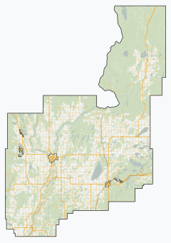
Geography
Communities and localities
| The following urban municipalities are surrounded by Athabasca County.[4]
| The following hamlets are located within Athabasca County.[4]
|
The following localities are located within Athabasca County.[5]
- Localities
|
|
Demographics
In the 2021 Census of Population conducted by Statistics Canada, Athabasca County had a population of 6,959 living in 2,832 of its 3,746 total private dwellings, a change of -11.6% from its 2016 population of 7,869. With a land area of 6,111.3 km2 (2,359.6 sq mi), it had a population density of 1.1/km2 (2.9/sq mi) in 2021.[2]
In the 2016 Census of Population conducted by Statistics Canada, Athabasca County had a population of 7,869 living in 3,067 of its 4,093 total private dwellings, a 2.7% change from its 2011 population of 7,662. With a land area of 6,124.43 km2 (2,364.66 sq mi), it had a population density of 1.3/km2 (3.3/sq mi) in 2016.[6]
| Visible minority and Aboriginal population (Canada 2006 Census) | |||
|---|---|---|---|
| Population group | Population | % of total population | |
| White | 6,650 | 87.7% | |
| Visible minority group Source:[7] | South Asian | 0 | 0% |
| Chinese | 15 | 0.2% | |
| Black | 35 | 0.5% | |
| Filipino | 20 | 0.3% | |
| Latin American | 0 | 0% | |
| Arab | 15 | 0.2% | |
| Southeast Asian | 25 | 0.3% | |
| West Asian | 0 | 0% | |
| Korean | 0 | 0% | |
| Japanese | 15 | 0.2% | |
| Visible minority, n.i.e. | 0 | 0% | |
| Multiple visible minority | 0 | 0% | |
| Total visible minority population | 125 | 1.6% | |
| Aboriginal group Source:[8] | First Nations | 310 | 4.1% |
| Métis | 500 | 6.6% | |
| Inuit | 0 | 0% | |
| Aboriginal, n.i.e. | 0 | 0% | |
| Multiple Aboriginal identity | 0 | 0% | |
| Total Aboriginal population | 810 | 10.7% | |
| Total population | 7,585 | 100% | |
See also
- List of communities in Alberta
- List of francophone communities in Alberta
- List of municipal districts in Alberta
References
- ^ "Municipal Officials Search". Alberta Municipal Affairs. May 9, 2019. Retrieved October 1, 2021.
- ^ a b c "Population and dwelling counts: Canada, provinces and territories, and census subdivisions (municipalities)". Statistics Canada. February 9, 2022. Retrieved February 9, 2022.
- ^ Province of Alberta. "Order in Council (O.C.) 563/2009". Retrieved December 6, 2009.
- ^ a b "Specialized and Rural Municipalities and Their Communities" (PDF). Alberta Municipal Affairs. January 12, 2022. Retrieved January 21, 2022.
- ^ "Standard Geographical Classification (SGC) 2006, Economic Regions: 4813044 - Athabasca County No. 12, geographical codes and localities, 2006". Statistics Canada. March 5, 2010. Archived from the original on March 8, 2012. Retrieved August 11, 2012.
- ^ "Population and dwelling counts, for Canada, provinces and territories, and census subdivisions (municipalities), 2016 and 2011 censuses – 100% data (Alberta)". Statistics Canada. February 8, 2017. Retrieved February 8, 2017.
- ^ Community Profiles from the 2006 Census, Statistics Canada - Census Subdivision
- ^ Aboriginal Population Profile from the 2006 Census, Statistics Canada - Census Subdivision
External links
- Official website

Places adjacent to Athabasca County | |
|---|---|


- v
- t
- e
Subdivisions of Alberta
service areas
municipalities
municipalities
- Crowsnest Pass, Municipality of
- Jasper, Municipality of
- Lac La Biche County
- Mackenzie County
- Strathcona County
- Wood Buffalo, Regional Municipality of
 Category
 Canada portal
 WikiProject


Authority control databases | |
|---|---|
| International |
|
| National |
|


