Axbridge Hill and Fry's Hill
Axbridge Hill and Fry's Hill (grid reference ST433555) is a 64.8-hectare (160-acre) biological Site of Special Scientific Interest in the Mendip Hills, Somerset, notified in 1990. The hills are above the town of Axbridge, immediately to the east of Shute Shelve Hill.
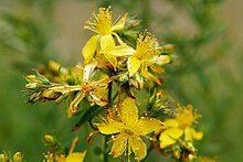
This is a nationally important botanical site, for both vascular and non-vascular plants, situated on the southern escarpment of the Mendip Hills. It also contains a roosting site for two nationally rare species of bat and a wide range of butterfly species. The very thin soils here support populations of one nationally rare species, Cheddar bedstraw (Galium fleurotii) and four nationally scarce species, pale St John's wort (Hypericum montanum), sea storksbill (Erodium maritimum), dwarf mouse-ear (Cerastium pumilum) and spring cinquefoil (Potentilla tabernaemontani). There is a roosting site for greater horseshoe bat (Rhinolophus ferrumequinum) and lesser horseshoe bat R. hipposideros, both of which are nationally rare. Dormice (Muscardinus avellanarius) are found in the woodland. Twenty-five species of butterfly have been recorded and these include: brown argus (Aricia agestis), green hairstreak (Callophrys rubi), dark green fritillary (Argynnis aglaja) and marbled white (Melanargia galathea).[1]
References
- ^ "Axbridge Hill and Fry's Hill" (PDF). English Nature. Archived from the original (PDF) on 13 October 2006. Retrieved 17 July 2006.
- v
- t
- e
- Ashwick
- Axbridge
- Banwell
- Bishop Sutton
- Blagdon
- Bleadon
- Burrington
- Charterhouse
- Cheddar
- Chewton Mendip
- Churchill
- Compton Bishop
- Compton Martin
- Cross
- Draycott
- East Harptree
- Easton
- Hinton Blewett
- Hutton
- Leigh-on-Mendip
- Litton
- Oakhill
- Priddy
- Rodney Stoke
- Rowberrow
- Sandford
- Shepton Mallet
- Shipham
- Ubley
- Webbington
- Wells
- West Harptree
- Westbury-sub-Mendip
- Winscombe
- Wookey Hole
- Axbridge Hill
- Black Down
- Bleadon Hill
- Burledge Hill
- Crook Peak
- Fry's Hill
- Pen Hill
- Purn Hill
- Shute Shelve Hill
- Wavering Down
- Attborough Swallet
- Aveline's Hole
- Axbridge Ochre Mine
- Banwell Caves
- Banwell Ochre Caves
- Burrington Combe
- Charterhouse Cave
- Cheddar Gorge
- Compton Martin Ochre Mine
- Cox's Cave
- Eastwater Cavern
- Ebbor Gorge
- Fairy Cave Quarry
- GB Cave
- Goatchurch Cavern
- Gough's Cave
- Hunter's Hole
- Lamb Leer
- Longwood Swallet
- Manor Farm Swallet
- Picken's Hole
- Pierre's Pot
- Priddy Caves
- Read's Cavern
- Reservoir Hole
- Rhino Rift
- Rod's Pot
- Shatter Cave
- Shute Shelve Cavern
- Sidcot Swallet
- St Cuthbert's Swallet
- St. Dunstan's Well Catchment
- Stoke Lane Slocker
- Swildon's Hole
- Thrupe Lane Swallet
- Tyning's Barrow Swallet
- Upper Flood Swallet
- W/L Cave
- Wookey Hole Caves
- Asham Wood
- Axbridge Hill and Fry's Hill
- Banwell Caves
- Banwell Ochre Caves
- Barns Batch Spinney
- Blagdon Lake
- Bleadon Hill
- Brimble Pit and Cross Swallet Basins
- Burledge Hill
- Burrington Combe
- Chancellor's Farm
- Cheddar Complex
- Cheddar Reservoir
- Cheddar Wood
- Chew Valley Lake
- Cloford Quarry
- Compton Martin Ochre Mine
- Cook's Wood Quarry
- Crook Peak to Shute Shelve Hill
- Dolebury Warren
- Draycott Sleights
- Ebbor Gorge
- Emborough Quarries
- Harptree Combe
- Hobbs Quarry
- Holwell Quarries
- Kingdown and Middledown
- Lamb Leer
- Priddy Caves
- Priddy Pools
- Perch
- Rodney Stoke
- St. Dunstan's Well Catchment
- Sandpit Hole and Bishop's Lot
- Shiplate Slait
- Viaduct Quarry
- Windsor Hill Quarry
- Wurt Pit and Devil's Punchbowl