Bathurst Street, Sydney
Street in Sydney, Australia

West end
East end
- 33°52′26″S 151°12′10″E / 33.873983°S 151.202814°E / -33.873983; 151.202814 (West end)
- 33°52′29″S 151°12′35″E / 33.874656°S 151.209734°E / -33.874656; 151.209734 (East end)
Sydney CBD
- Sussex Street
- Kent Street
- George Street
- Pitt Street
- Castlereagh Street
Sydney CBD
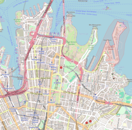
Bathurst Street is a street in the Sydney central business district in New South Wales, Australia. Bathurst Street runs for 650 metres (2,130 ft) in a west–east direction with traffic flowing in this direction only.[1][2] It is situated in the southern portion of the central business district. The western terminus of Bathurst Street is at Harbour Street, Darling Harbour, with the eastern terminus at Elizabeth Street, adjacent to Hyde Park.
From west to east, Bathurst Street crosses Sussex, George, Pitt, and Castlereagh streets.
Bathurst Street was named by Governor Macquarie in honour of Henry Bathurst, 3rd Earl Bathurst, the UK Secretary of State for War and the Colonies between 1812 and 1827.[3][4] In conjunction with the opening of the Glebe Island Bridge, in December 1995 a bus lane was opened from Harbour to George Streets.[5]
Landmarks
- The Hyde Park Obelisk, at the eastern end of Bathurst Street, was erected in 1857 and unveiled by the Mayor, George Thornton. The monument is actually a sewer vent, and soon the joke around town was to call it 'Thornton's Scent Bottle'.[6] The obelisk is an example of the Victorian Egyptian style and was based on Cleopatra's Needle in London.[7]: 99 It is listed on the NSW State Heritage Register.[8]
- The Church of England St Andrew's Cathedral sits on the north-west corner of Bathurst Street and George Street. It was designed by Edmund Blacket and was listed on the Register of the National Estate.[7]: 100
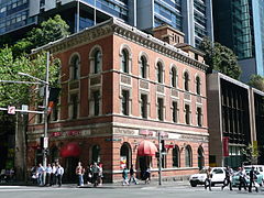
- The former Bank of New South Wales building sits on the south-west corner of Bathurst Street and George Street. It was designed by Varney Parkes and built in 1894 in the American Romanesque style. It is listed on the NSW State Heritage Register.[9][7]: 101
- The Vintage building is situated on the corner of Bathurst and Sussex Streets. It was built in the 1890s and was just one of many warehouses that sprang up in the area because of its proximity to Darling Harbour. It was used as a flour mill while owned by Aitken and Son; later owners included Mungo Scott Ltd. In 1979 it was converted to residential apartments.[citation needed]
- 107–109 Bathurst St – Former Bank of NSW
Gallery
-
 Hyde Park Obelisk
 -
 The Vintage Building
 -
 St Andrew's Cathedral, west side
 -
 Former Bank of New South Wales


See also
 Australian Roads portal

![]() Media related to Bathurst Street, Sydney at Wikimedia Commons
Media related to Bathurst Street, Sydney at Wikimedia Commons
References
KML file (edit • help)
Template:Attached KML/Bathurst Street, Sydney
KML is from Wikidata
- ^ a b Bathurst St, Sydney NSW 2000 to 120 Elizabeth St, Sydney NSW 2000 (Map). Google Maps. 2016. Retrieved 27 December 2016.
- ^ Maps C, D (Map). Gregory's Sydney Street Directory. 2002.
- ^ "What's in a name?". Sydney Streets. City of Sydney. 2003. Archived from the original on 30 December 2016. Retrieved 29 December 2016.
- ^ "History of Sydney Streets" (MS Excel (for download)). Sydney Streets. City of Sydney. 4 December 2012. Retrieved 29 December 2016.
- ^ Central City Bus Priority Scheme Australian Bus Panorama issue 13/1 August 1997 page 33
- ^ "Thornton's Scent Bottle". Water Supply and Sewerage. City of Sydney. Archived from the original on 8 April 2003.
- ^ a b c Australian Heritage Commission (1981), The Heritage of Australia: the illustrated register of the National Estate, South Melbourne: The Macmillan Company of Australia in association with the Australian Heritage Commission, ISBN 978-0-333-33750-9
- ^ "Sewer Vent". NSW State Heritage Register. Office of Environment & Heritage. 30 November 2001. Retrieved 27 December 2016.
- ^ "Bank of NSW". NSW State Heritage Register. Office of Environment & Heritage. 5 September 2008. Retrieved 27 December 2016.
- v
- t
- e
Streets of Sydney, New South Wales, Australia
- Albion Street
- Alfred Street
- Bathurst Street
- Bridge Street
- Bayswater Road
- Broadway
- Castlereagh Street
- Chalmers Street
- City Road
- Clarence Street
- Cleveland Street
- College Street
- Crown Street
- Eddy Avenue
- Elizabeth Street
- George Street
- Glebe Point Road
- Goulburn Street
- Grosvenor Street
- Harris Street
- Hay Street
- Hunter Street
- Kent Street
- King Street
- Lime Street
- Liverpool Street
- Macquarie Street
- Market Street
- Martin Place
- Oxford Street
- Park Street
- Phillip Street
- Pitt Street
- Queen's Square
- Rowe Street
- Stanley Street
- Sussex Street
- Victoria Street
- Whitlam Square
- William Street
- York Street
- Anzac Parade
- Appian Way
- Bangor Bypass
- Barrenjoey Road
- Blacktown Road
- Bondi Road
- Burnt Bridge Creek Deviation
- City West Link
- Cumberland Highway
- Darling Street
- Epping Road
- General Holmes Drive
- Gore Hill Freeway
- Great North Road
- Great Western Highway
- Heathcote Road
- Henry Lawson Drive
- The Horsley Drive
- Hume Highway
- James Ruse Drive
- Jeffrey Street
- King Georges Road
- King Street
- Lane Cove Road
- New South Head Road
- Norton Street
- Old South Head Road
- Old Windsor Road
- Parramatta Road
- Pennant Hills Road
- Pittwater Road
- Princes Highway
- Prospect Highway
- Richmond Road
- Ryde Road
- Southern Cross Drive
- Syd Einfeld Drive
- Taren Point Road
- Victoria Road
- Windsor Road
- Wolseley Road


