Bellingshausen Sea
Part of the Southern Ocean along the Antarctic Peninsula

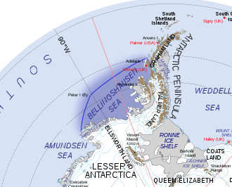
The Bellingshausen Sea is an area along the west side of the Antarctic Peninsula between 57°18'W and 102°20'W, west of Alexander Island, east of Cape Flying Fish on Thurston Island, and south of Peter I Island (there the southern Vostokkysten).[1] The Bellingshausen Sea borders the Eights Coast, the Bryan Coast, and the west part of the English Coast. To the west of Cape Flying Fish it joins the Amundsen Sea.
Bellingshausen Sea has an area of 487,000 km2 (188,000 sq mi) and reaches a maximum depth of 4.5 kilometers (2.8 mi).[2] It contains the undersea plain Bellingshausen Plain.
The Antarctic Slope Current (ASC) is thought to originate in the Bellingshausen Sea as the result of a density front at the shelf break, rather than being wind-driven.[3]
It takes its name from Admiral Thaddeus Bellingshausen, who explored in the area in 1821.
In the late Pliocene Epoch, about 2.15 million years ago, the Eltanin asteroid (about 1-4 km in diameter) impacted at the edge of the Bellingshausen sea (at the Southern Ocean). This is the only known impact in a deep-ocean basin in the world.[4]
References
- ^ Australian Antarctic Data Centre, Antarctic Gazetteer: Bellingshausen Sea
- ^ Gazetteer «About countries»: Bellingshausen (sea)
- ^ Thompson, Andrew F.; Speer, Kevin G.; Schulze Chretien, Lena M. (2020-08-28). "Genesis of the Antarctic Slope Current in West Antarctica" (PDF). Geophysical Research Letters. 47 (16). doi:10.1029/2020GL087802. ISSN 0094-8276.
- ^ Gersonde, Rainer; F. T. Kyte; T. Frederichs; U. Bleil; H.-W. Schenke; G. Kuhn (2005). "The late Pliocene impact of the Eltanin asteroid into the Southern Ocean – Documentation and environmental consequences" (PDF). Geophysical Research Abstracts. 7. 1607-7962/gra/EGU05-A-02449. Retrieved 2008-06-22.
 This article incorporates public domain material from "Bellingshausen Sea". Geographic Names Information System. United States Geological Survey.
External links
- NASA Bellinghausen Sea satellite photo
- Bellinghausen Sea climatological low pressure system
- v
- t
- e
- Adriatic Sea
- Aegean Sea
- Alboran Sea
- American Mediterranean Sea
- Archipelago Sea
- Argentine Sea
- Baffin Bay
- Balearic Sea
- Baltic Sea
- Bay of Biscay
- Bay of Bothnia
- Bay of Campeche
- Bay of Fundy
- Black Sea
- Bothnian Sea
- Caribbean Sea
- Celtic Sea
- English Channel
- Foxe Basin
- Greenland Sea
- Gulf of Bothnia
- Gulf of Finland
- Gulf of Lion
- Gulf of Guinea
- Gulf of Maine
- Gulf of Mexico
- Gulf of Saint Lawrence
- Gulf of Sidra
- Gulf of Venezuela
- Hudson Bay
- Ionian Sea
- Irish Sea
- Irminger Sea
- James Bay
- Labrador Sea
- Levantine Sea
- Libyan Sea
- Ligurian Sea
- Marmara Sea
- Mediterranean Sea
- Myrtoan Sea
- North Sea
- Norwegian Sea
- Sargasso Sea
- Sea of Åland
- Sea of Azov
- Sea of Crete
- Sea of the Hebrides
- Thracian Sea
- Tyrrhenian Sea
- Wadden Sea
- Arafura Sea
- Bali Sea
- Banda Sea
- Bering Sea
- Bismarck Sea
- Bohai Sea
- Bohol Sea
- Camotes Sea
- Celebes Sea
- Chilean Sea
- Coral Sea
- East China Sea
- Gulf of Alaska
- Gulf of Anadyr
- Gulf of California
- Gulf of Carpentaria
- Gulf of Fonseca
- Gulf of Panama
- Gulf of Thailand
- Gulf of Tonkin
- Halmahera Sea
- Java Sea
- Koro Sea
- Mar de Grau
- Molucca Sea
- Moro Gulf
- Philippine Sea
- Salish Sea
- Savu Sea
- Sea of Japan
- Sea of Okhotsk
- Seram Sea
- Seto Inland Sea
- Shantar Sea
- Sibuyan Sea
- Solomon Sea
- South China Sea
- Sulu Sea
- Tasman Sea
- Visayan Sea
- Yellow Sea
 Oceans portal
 Category


Authority control databases | |
|---|---|
| International |
|
| National |
|
| Other |
|
71°S 85°W / 71°S 85°W / -71; -85


