Brommaplan metro station
Stockholm Metro station
59°20′18″N 17°56′22″E / 59.33833°N 17.93944°E / 59.33833; 17.93944| Preceding station |  Stockholm metro Stockholm metro | Following station | ||
|---|---|---|---|---|
| Åkeshov Terminus | Line 17 | Abrahamsberg towards Skarpnäck | ||
| Åkeshov towards Hässelby strand | Line 19 | Abrahamsberg towards Hagsätra | ||
Location | |
|---|---|
 |
Brommaplan metro station is a station on the Green line of the Stockholm metro. It is located in the district of Riksby, which is part of the borough of Bromma in the west of the city of Stockholm. The station is elevated and has a single island platform, with access from a lower level station building.[2][3][4] The distance to Slussen is 10.5 km (6.5 mi).[citation needed]
The station lies on the route of a line known as the Ängbybanan [sv] that formerly linked Alvik and Islandstorget. The Ängbybanan, which included the elevated tracks at Brommaplan now used by the metro, was designed and built for use by the future metro, but was operated from 1944 as part of line 11 of the Stockholm tramway. Brommaplan station was inaugurated as part of the metro on 26 October 1952 with the conversion of the Ängbybanan and its extension to form the metro line between Hötorget and Vällingby.[2][5]
As part of Art in the Stockholm metro project, the station received a composition in glass, stainless sheet metal and aluminium referring to the history of aviation and the nearby Bromma Airport. The artwork was created by Peter Svedberg and installed in 1996[6]
Gallery
-
 Elevated tracks across Brommaplan, 2007
 -
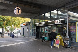 Entrance to the station, 2018
 -
 inside the station, 2018
 -
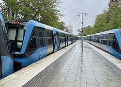 The platforms, 2021


References
- ^ "Fakta om SL och regionen 2019" (PDF) (in Swedish). Storstockholms Lokaltrafik. p. 51. Archived (PDF) from the original on 27 December 2020. Retrieved 29 March 2021.
- ^ a b Schwandl, Robert. "Stockholm". urbanrail. Archived from the original on 23 April 2019. Retrieved 7 May 2019.
- ^ Alfredsson, Björn; Bernt, Roland; Harlén, Hans (2007). Stockholm Under. Brombergs Bokförlag. p. 58. ISBN 978-91-7337-051-6.
- ^ "Brommaplan". Google maps. Retrieved 9 March 2022.
- ^ Jacobson, Per (1998). En spårväg till Bromma [A tramway to Bromma] (in Swedish). Oslo: Baneforlaget. ISBN 82-91448-25-6.
- ^ "Art in the Stockholm metro" (PDF). Stockholm Transport. Archived from the original (PDF) on 13 September 2008. Retrieved 10 September 2008.
- v
- t
- e

| Shared stations | |
|---|---|
| 17 |
|
| 18 |
|
| 19 |


 | This article about a Swedish railway station is a stub. You can help Wikipedia by expanding it. |
- v
- t
- e
 | This Stockholm Metro article is a stub. You can help Wikipedia by expanding it. |
- v
- t
- e


