Cabarita, New South Wales
Suburb of Sydney, New South Wales, Australia
| Cabarita Sydney, New South Wales | |||||||||||||||
|---|---|---|---|---|---|---|---|---|---|---|---|---|---|---|---|
 Cape Cabarita | |||||||||||||||
 Map | |||||||||||||||
| Population | 1,957 (2016 census)[1] | ||||||||||||||
| Postcode(s) | 2137 | ||||||||||||||
| Elevation | 16 m (52 ft) | ||||||||||||||
| Location | 16 km (10 mi) west of Sydney CBD | ||||||||||||||
| LGA(s) | City of Canada Bay | ||||||||||||||
| State electorate(s) | Drummoyne | ||||||||||||||
| Federal division(s) | Reid | ||||||||||||||
| |||||||||||||||
Cabarita is a bayside suburb in the Inner West[2] of Sydney, in the state of New South Wales, Australia. Cabarita is located 16 kilometres west of the Sydney central business district, in the local government area of the City of Canada Bay.
Geography
Cabarita is a picturesque suburb on the Parramatta River, north of Concord. Opened in 2015, when the water was deemed clean and safe for swimmers after 70 years, the 200-metre long Cabarita Beach in Cabarita Park is one of the most proximate swimming beaches to many suburbs in western Sydney.[3] The park features a shaded playground area, a large conservatory, a toddler pool, a kiosk, and barbecue spots with a hilly area that provides water views.[4]
History

Cabarita is an Aboriginal word meaning by the water.[5]
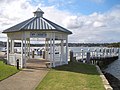
David Anderson, a private soldier in the NSW Corps was granted land in this area in 1795. An area of Cabarita Point was reserved for public recreation in 1856. The reserve was expanded in 1880 with the addition of 9.7 hectares of adjoining land, known as Correy's Garden.[5] The pavilion from which Governor-General Lord Hopetoun proclaimed the Federation of Australia in 1901 was later moved from Centennial Park to Cabarita Park.
In the past, the suburb consisted of swampland and heavy industry. Housing developments replaced the industry and the swamps. Until 1948, an electric tramway ran down Cabarita Road to connect the suburb with Burwood, Enfield and Ashfield via Cabarita Junction near the corner of Mortlake Street.
Heritage listings
Cabarita has a number of heritage-listed sites, including:
- Cabarita Road: Federation Pavilion, Cabarita Park[6]
Demographics
According to the 2016 census of Population, there were 1,957 people in Cabarita. 65.0% of people were born in Australia. The next most common country of birth was China at 5.6%. 66.0% of people spoke only English at home. Other languages spoken at home included Italian 5.9%, and Cantonese 5.3%. The most common responses for religion in Cabarita were Catholic 38.3%, No Religion 20.1% and Anglican 12.6%.[1]
Transport
Cabarita ferry wharf provides access to the Parramatta River ferry services.
-
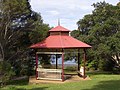
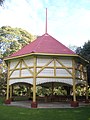 Federation Pavilion, Cabarita Park
 -
 Federation Pavilion, Cabarita Park
 -
 William Beach monument, Cabarita Park
 -
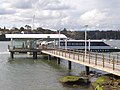 Cabarita wharf and Rivercat ferry


Housing
Cabarita and the adjacent Breakfast Point have many new housing communities along the waterfront, such as Cape Cabarita and Edgewood. These developments feature many recreational facilities such as playing fields, gymnasiums, golf courses and some restaurants. Prince Edward Park sits beside Cape Cabarita.
-
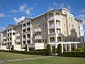 Cape Cabarita
 -
 Cape Cabarita wharf
 -
 Prince Edward Park
 -
 Home in Tudor style


References
- ^ a b Australian Bureau of Statistics (27 June 2017). "Cabarita (State Suburb)". 2016 Census QuickStats. Retrieved 14 March 2018.

- ^ Australian Suburb Guide: Sydney Inner West Archived 26 December 2012 at the Wayback Machine Retrieved 7 August 2013.
- ^ Cabarita Beach and Chiswick Baths safe for inner west swimmers this summer by The Daily Telegraph, 8 December 2015
- ^ Cabarita Park – Play, Swimming and Picnics | Cabarita
- ^ a b Blaxell, Gregory (2007). The River: Sydney Cove to Parramatta. Halstead Press. p. 123. ISBN 9781920831738.
- ^ "Federation Pavilion, Cabarita Park". New South Wales State Heritage Register. Department of Planning & Environment. H01454. Retrieved 18 May 2018.
 Text is licensed by State of New South Wales (Department of Planning and Environment) under CC-BY 4.0 licence.
Wikimedia Commons has media related to Cabarita, New South Wales.
33°50′53″S 151°06′53″E / 33.84802°S 151.11485°E / -33.84802; 151.11485
- v
- t
- e


