Castanheira de Pera
Municipality in Centro, Portugal

Flag

Coat of arms

 Portugal
 (2011)
Castanheira de Pera (Portuguese pronunciation: [kɐʃtɐˈɲɐjɾɐ ðɨ ˈpeɾɐ] ⓘ), often erroneously written Castanheira de Pêra, is a municipality in the district of Leiria in Portugal. The population in 2011 was 3,191,[1] in an area of 66.77 km².[2]
The present Mayor is Fernando José Pires Lopes, elected by the Socialist Party. The municipal holiday is on July 4.
-
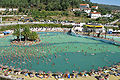 Roca's Beach
 -
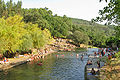 Corga
Corga -
 Véras
Véras -
 St. António da Neve


Parishes
Administratively, the municipality consists of 1 civil parish (freguesia):[3]
- Castanheira de Pera e Coentral
Climate
| Climate data for Castanheira de Pera, 1934-1960 normals, 1981-2021 precipitation | |||||||||||||
|---|---|---|---|---|---|---|---|---|---|---|---|---|---|
| Month | Jan | Feb | Mar | Apr | May | Jun | Jul | Aug | Sep | Oct | Nov | Dec | Year |
| Mean daily maximum °C (°F) | 13.7 (56.7) | 15.3 (59.5) | 17.7 (63.9) | 20.7 (69.3) | 22.4 (72.3) | 26.9 (80.4) | 30.2 (86.4) | 30.7 (87.3) | 28.2 (82.8) | 23.2 (73.8) | 17.9 (64.2) | 14.4 (57.9) | 21.8 (71.2) |
| Daily mean °C (°F) | 8.9 (48.0) | 9.9 (49.8) | 12.2 (54.0) | 14.6 (58.3) | 16.2 (61.2) | 19.9 (67.8) | 22.4 (72.3) | 22.7 (72.9) | 20.8 (69.4) | 17.0 (62.6) | 12.6 (54.7) | 9.4 (48.9) | 15.6 (60.0) |
| Mean daily minimum °C (°F) | 4.1 (39.4) | 4.5 (40.1) | 6.8 (44.2) | 8.4 (47.1) | 10.0 (50.0) | 12.9 (55.2) | 14.5 (58.1) | 14.7 (58.5) | 13.4 (56.1) | 10.7 (51.3) | 7.4 (45.3) | 4.4 (39.9) | 9.3 (48.8) |
| Average precipitation mm (inches) | 207.2 (8.16) | 174.8 (6.88) | 103.1 (4.06) | 155.8 (6.13) | 144.5 (5.69) | 52.1 (2.05) | 11.5 (0.45) | 16.3 (0.64) | 60.1 (2.37) | 175.9 (6.93) | 195.9 (7.71) | 231.6 (9.12) | 1,528.8 (60.19) |
| Average relative humidity (%) | 80 | 76 | 72 | 68 | 69 | 60 | 60 | 60 | 65 | 72 | 78 | 80 | 70 |
| Source: Portuguese Environment Agency[4][5] | |||||||||||||
Notable people
- Kalidás Barreto (1932–2020) a Portuguese accountant and trade unionist; active in Castanheira de Pera where he died
- João Carvalho (born 1997) a Portuguese footballer with nearly 200 club caps, he plays for Nottingham Forest F.C.
References
- ^ Instituto Nacional de Estatística Archived November 15, 2016, at the Wayback Machine
- ^ "Áreas das freguesias, concelhos, distritos e país". Archived from the original on 2018-11-05. Retrieved 2018-11-05.
- ^ Diário da República. "Law nr. 11-A/2013, page 552 34" (pdf) (in Portuguese). Retrieved 20 July 2014.
- ^ "Plano Municipal de Defesa da Floresta Contra Incêndios" (PDF). Castanheira de Pera Municipality. Retrieved 25 June 2021.
- ^ "SNIRH > Dados de Base". snirh.apambiente.pt. Retrieved 25 June 2021.
External links
- Municipality official website
Authority control databases | |
|---|---|
| International |
|
| National |
|
| Other |
|
 | This Leiria location article is a stub. You can help Wikipedia by expanding it. |
- v
- t
- e


