El Doncello
Municipality and town in Caquetá Department, Colombia

Flag

Seal
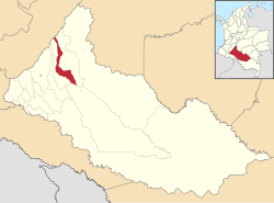
Location of the municipality and town of El Doncello in the Caquetá Department of Colombia.
 Colombia
 (Census 2018[1])
El Doncello is a town and municipality in Caquetá Department, Colombia with a population, according to a 2018 census, of 17,775.[1] There is evidence that it was first settled in the 1930s, but most large-scale official building occurred from the 1950s onwards. The immigrant families that first settled El Doncello came from various neighbouring regions and were mainly avoiding the monopolization of land in the country's centre; the colonization was more or less spontaneous, as there was no institution overseeing the process.
Climate
| Climate data for El Doncello (Maguare), elevation 270 m (890 ft), (1981–2010) | |||||||||||||
|---|---|---|---|---|---|---|---|---|---|---|---|---|---|
| Month | Jan | Feb | Mar | Apr | May | Jun | Jul | Aug | Sep | Oct | Nov | Dec | Year |
| Mean daily maximum °C (°F) | 32.7 (90.9) | 32.3 (90.1) | 31.2 (88.2) | 30.5 (86.9) | 29.8 (85.6) | 28.9 (84.0) | 28.7 (83.7) | 29.9 (85.8) | 30.8 (87.4) | 31.0 (87.8) | 30.8 (87.4) | 31.8 (89.2) | 30.7 (87.3) |
| Daily mean °C (°F) | 26.8 (80.2) | 26.5 (79.7) | 25.9 (78.6) | 25.4 (77.7) | 25.1 (77.2) | 24.4 (75.9) | 24.2 (75.6) | 24.8 (76.6) | 25.4 (77.7) | 25.6 (78.1) | 25.8 (78.4) | 26.2 (79.2) | 25.5 (77.9) |
| Mean daily minimum °C (°F) | 20.8 (69.4) | 21.2 (70.2) | 21.5 (70.7) | 21.6 (70.9) | 21.5 (70.7) | 20.8 (69.4) | 20.3 (68.5) | 20.4 (68.7) | 20.7 (69.3) | 21.1 (70.0) | 21.4 (70.5) | 21.0 (69.8) | 21.0 (69.8) |
| Average precipitation mm (inches) | 76.4 (3.01) | 144.1 (5.67) | 292.2 (11.50) | 417.2 (16.43) | 370.9 (14.60) | 348.3 (13.71) | 303.5 (11.95) | 210.5 (8.29) | 234.8 (9.24) | 286.8 (11.29) | 213.5 (8.41) | 95.4 (3.76) | 2,942.3 (115.84) |
| Average precipitation days | 8 | 12 | 18 | 23 | 24 | 24 | 22 | 20 | 19 | 19 | 17 | 10 | 209 |
| Average relative humidity (%) | 75 | 78 | 83 | 86 | 86 | 87 | 86 | 84 | 83 | 83 | 83 | 80 | 83 |
| Mean monthly sunshine hours | 186.0 | 132.7 | 102.3 | 96.0 | 105.4 | 93.0 | 102.3 | 130.2 | 147.0 | 148.8 | 150.0 | 182.9 | 1,576.6 |
| Mean daily sunshine hours | 6.0 | 4.7 | 3.3 | 3.2 | 3.4 | 3.1 | 3.3 | 4.2 | 4.9 | 4.8 | 5.0 | 5.9 | 4.3 |
| Source: Instituto de Hidrologia Meteorologia y Estudios Ambientales[2] | |||||||||||||
References
- v
- t
- e
Municipalities in the Caquetá Department
- Albania
- Belén de Andaquies
- Cartagena del Chairá
- Curillo
- El Doncello
- El Paujil
- Florencia
- La Montañita
- Milán
- Morelia
- Puerto Rico
- San José del Fragua
- San Vicente del Caguán
- Solano
- Solita
- Valparaíso

1°41′N 75°17′W / 1.683°N 75.283°W / 1.683; -75.283
 | This Caquetá Department location article is a stub. You can help Wikipedia by expanding it. |
- v
- t
- e


