Frohnleiten
Place in Styria, Austria

Coat of arms

Location within Graz-Umgebung district
(2018-01-01)[2]
8130
Frohnleiten (German: [fʁonˈlaɪ̯tn̩]) is a town in the district of Graz-Umgebung in the Austrian state of Styria.
-
 Town Hall of Frohnleiten
 -
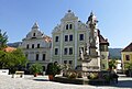 Baroque gables at the main square of Frohnleiten
 -
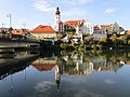 View of the old town center from a bridge over the river Mur


Population
| Year | Pop. | ±% |
|---|---|---|
| 1869 | 3,843 | — |
| 1880 | 4,161 | +8.3% |
| 1890 | 4,457 | +7.1% |
| 1900 | 4,700 | +5.5% |
| 1910 | 5,117 | +8.9% |
| 1923 | 5,253 | +2.7% |
| 1934 | 5,936 | +13.0% |
| 1939 | 5,827 | −1.8% |
| 1951 | 6,718 | +15.3% |
| 1961 | 6,978 | +3.9% |
| 1971 | 7,056 | +1.1% |
| 1981 | 6,774 | −4.0% |
| 1991 | 6,841 | +1.0% |
| 2001 | 6,592 | −3.6% |
| 2011 | 6,062 | −8.0% |
Transportation
Frohnleiten lies on the main southern railway line connecting Vienna and Graz. The journey from Graz main station to Frohnleiten takes approximately 25 minutes. Starting from the railway station the old town center can be reached by walking over a bridge over the River Mur in about 10 minutes.
Main sights
In Frohnleiten and its surroundings are several castles and manor houses with historical importance.

- Burg Rabenstein
- Schloss Weyer
- Schloss Neu-Pfannberg
Many buildings that are close to the main square of Frohnleiten have been constructed during the 15-16th century and were part of a fortification.


References
- v
- t
- e
Municipalities in the district of Graz-Umgebung
- Deutschfeistritz
- Dobl-Zwaring
- Eggersdorf bei Graz
- Feldkirchen bei Graz
- Fernitz-Mellach
- Frohnleiten
- Gössendorf
- Gratkorn
- Gratwein-Straßengel
- Hart bei Graz
- Haselsdorf-Tobelbad
- Hausmannstätten
- Hitzendorf
- Kainbach bei Graz
- Kalsdorf bei Graz
- Kumberg
- Laßnitzhöhe
- Lieboch
- Nestelbach bei Graz
- Peggau
- Premstätten
- Raaba-Grambach
- Sankt Bartholomä
- Sankt Marein bei Graz
- Sankt Oswald bei Plankenwarth
- Sankt Radegund bei Graz
- Seiersberg-Pirka
- Semriach
- Stattegg
- Stiwoll
- Thal
- Übelbach
- Vasoldsberg
- Weinitzen
- Werndorf
- Wundschuh
Authority control databases | |
|---|---|
| International |
|
| National |
|
| Geographic |
|
 | This Styria location article is a stub. You can help Wikipedia by expanding it. |
- v
- t
- e


