Grade II* listed buildings in City of Canterbury
Map all coordinates using OpenStreetMap
Download coordinates as:
- KML
- GPX (all coordinates)
- GPX (primary coordinates)
- GPX (secondary coordinates)
There are over 20,000 Grade II* listed buildings in England. This page is a list of these buildings in the district of Canterbury in Kent.
List of buildings
| Name | Location | Type | Completed [note 1] | Date designated | Grid ref.[note 2] Geo-coordinates | Entry number [note 3] | Image |
|---|---|---|---|---|---|---|---|
| Anne Court, Barham Court | Barham | Apartment | 17th century | 29 September 1952 | TR2098850059 51°12′25″N 1°09′44″E / 51.206967°N 1.162306°E / 51.206967; 1.162306 (Anne Court, Barham Court) | 1336516 |  Upload Photo |
| The Steward's House, Broome Park Hotel | Barham | Steward's house | c.1778 | 30 January 1967 | TR2203648172 51°11′23″N 1°10′34″E / 51.189619°N 1.176118°E / 51.189619; 1.176118 (The Steward's House, Broome Park Hotel) | 1111767 |  More images |
| Higham Park (formerly Highland Court Hospital) | Bekesbourne-with-Patrixbourne | Country house | 18th century | 14 March 1980 | TR1934253763 51°14′27″N 1°08′28″E / 51.240857°N 1.141044°E / 51.240857; 1.141044 (Higham Park (formerly Highland Court Hospital)) | 1085542 |  More images |
| Howletts Wild Animal Park | Howletts Zoo Park, Bekesbourne-with-Patrixbourne | House | 1787 | 30 January 1967 | TR1962356736 51°16′03″N 1°08′49″E / 51.267441°N 1.146887°E / 51.267441; 1.146887 (Howletts Wild Animal Park) | 1336480 | 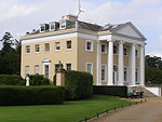 More images |
| Charlton Park | Bishopsbourne | House | 16th century with 18th-century frontage | 29 September 1952 | TR1902651770 51°13′23″N 1°08′07″E / 51.223084°N 1.135307°E / 51.223084; 1.135307 (Charlton Park) | 1350018 |  |
| Bridge Place | Bridge | Country house | Late 17th century | 29 September 1952 | TR1812153908 51°14′33″N 1°07′25″E / 51.242627°N 1.123667°E / 51.242627; 1.123667 (Bridge Place) | 1336506 |  More images |
| Church of St Peter | Bridge | Church | 12th century, restored 1859–61 | 30 January 1967 | TR1834554112 51°14′40″N 1°07′37″E / 51.244372°N 1.126996°E / 51.244372; 1.126996 (Church of St Peter) | 1336512 |  More images |
| Mystole Coach House | Mystole House, Chartham | Bell tower | Early 18th century | 30 January 1967 | TR0950553706 51°14′39″N 1°00′01″E / 51.24404°N 1.000292°E / 51.24404; 1.000292 (Mystole Coach House) | 1100332 | Upload Photo |
| Mystole House, South Mystole and West Wing | Mystole House, Chartham | House | 1980 | 29 September 1952 | TR0952053752 51°14′40″N 1°00′02″E / 51.244447°N 1.000533°E / 51.244447; 1.000533 (Mystole House, South Mystole and West Wing) | 1085682 | 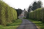 More images |
| The Deanery | Chartham | House | 17th century | 30 January 1967 | TR1007255087 51°15′22″N 1°00′33″E / 51.256232°N 1.009214°E / 51.256232; 1.009214 (The Deanery) | 1085676 | Upload Photo |
| Tudor House | Chislet | House | c.1500 | 29 September 1952 | TR2165964039 51°19′56″N 1°10′50″E / 51.33222°N 1.180556°E / 51.33222; 1.180556 (Tudor House) | 1084381 | Upload Photo |
| The Town Hall and The Crane House, with the stocks outside the Town Hall | Fordwich | Prison | Probably early 15th century | 29 September 1952 | TR1804759814 51°17′44″N 1°07′34″E / 51.295681°N 1.126208°E / 51.295681; 1.126208 (The Town Hall and The Crane House, with the stocks outside the Town Hall) | 1085670 |  More images |
| Watergate Cottage & Watergate House | Fordwich | House | 1967 | 30 January 1967 | TR1804659780 51°17′43″N 1°07′34″E / 51.295377°N 1.126173°E / 51.295377; 1.126173 (Watergate Cottage & Watergate House) | 1065708 |  More images |
| Church of the Holy Cross | Hoath | Bell tower | 1842 | 30 January 1967 | TR2030864190 51°20′03″N 1°09′41″E / 51.3341°N 1.161288°E / 51.3341; 1.161288 (Church of the Holy Cross) | 1085646 | 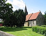 More images |
| Shelvingford Farmhouse | Shelvingford, Hoath | House | Late 15th century | 29 May 2015 | TR2114265405 | 1336522 |  |
| Maypole Thatch | Maypole, Hoath | House | Later-Post c1385 | 14 March 1980 | TR2041464967 51°20′28″N 1°09′48″E / 51.341035°N 1.163288°E / 51.341035; 1.163288 (Maypole Thatch) | 1343666 | Upload Photo |
| New Place | Ickham and Well | House | 16th century | 29 September 1952 | TR2228757870 51°16′36″N 1°11′09″E / 51.27659°N 1.185716°E / 51.27659; 1.185716 (New Place) | 1085607 | Upload Photo |
| The Old Rectory | Ickham, Ickham and Well | Manor house | 13th century | 29 September 1952 | TR2197658249 51°16′48″N 1°10′53″E / 51.280114°N 1.1815°E / 51.280114; 1.1815 (The Old Rectory) | 1373865 |  More images |
| Elbridge Farmhouse | Littlebourne | Farmhouse | 15th century | 29 September 1952 | TR2031959591 51°17′34″N 1°09′31″E / 51.292805°N 1.158606°E / 51.292805; 1.158606 (Elbridge Farmhouse) | 1372874 |  |
| Kenfield Hall | Petham | Country house | c.1730 | 29 September 1952 | TR1197252520 51°13′57″N 1°02′06″E / 51.23248°N 1.034884°E / 51.23248; 1.034884 (Kenfield Hall) | 1336559 | Upload Photo |
| Old Hall | Petham | House | 14th century | 14 March 1980 | TR1276751433 51°13′21″N 1°02′44″E / 51.222424°N 1.045609°E / 51.222424; 1.045609 (Old Hall) | 1054019 |  |
| Church of St Cosmus and St Damian | Blean, St. Cosmus and St. Damian in the Blean | Church | 13th century | 30 January 1967 | TR1290460666 51°18′19″N 1°03′11″E / 51.305276°N 1.05306°E / 51.305276; 1.05306 (Church of St Cosmus and St Damian) | 1085522 |  More images |
| Chapel of St John the Baptist, Milton | Thanington, Thanington Without | Chapel | 13th century | 30 January 1967 | TR1204355693 51°15′39″N 1°02′16″E / 51.260944°N 1.037777°E / 51.260944; 1.037777 (Chapel of St John the Baptist, Milton) | 1370012 |  More images |
| Church of St Nicholas | Thanington, Thanington Without | Church | Norman | 30 January 1967 | TR1315856782 51°16′13″N 1°03′16″E / 51.270307°N 1.054382°E / 51.270307; 1.054382 (Church of St Nicholas) | 1336614 | 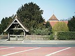 More images |
| Tonford Manor | Thanington Without | House | 1449 | 29 September 1952 | TR1249357040 51°16′22″N 1°02′42″E / 51.272872°N 1.045017°E / 51.272872; 1.045017 (Tonford Manor) | 1045882 |  More images |
| Barn at Hardres Court | Hardres Court, Upper Hardres | Aisled barn | Late 15th to early 16th century | 14 March 1980 | TR1529650678 51°12′53″N 1°04′53″E / 51.214697°N 1.081317°E / 51.214697; 1.081317 (Barn at Hardres Court) | 1085505 | Upload Photo |
| Handville Green | Anvil Green, Waltham | House | 16th century | 14 March 1980 | TR1089849622 51°12′25″N 1°01′04″E / 51.206855°N 1.017819°E / 51.206855; 1.017819 (Handville Green) | 1085517 | Upload Photo |
| Westbere House | Westbere | House | c.1800 | 29 September 1952 | TR1925461036 51°18′22″N 1°08′39″E / 51.30619°N 1.144243°E / 51.30619; 1.144243 (Westbere House) | 1367055 |  More images |
| The Old Stone House (formerly The Post Office) | Wickhambreaux | House | 16th century or earlier | 29 September 1952 | TR2206658658 51°17′02″N 1°10′59″E / 51.283751°N 1.183042°E / 51.283751; 1.183042 (The Old Stone House (formerly The Post Office)) | 1054855 |  |
| Wickham House | Wickhambreaux | Vicarage | 1713 | 30 January 1967 | TR2208858792 51°17′06″N 1°11′00″E / 51.284945°N 1.183441°E / 51.284945; 1.183441 (Wickham House) | 1085492 | 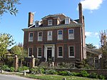 More images |
| Chapel to St John's Hospital | Canterbury | Chapel | Late 11th/early 12th century | 3 December 1949 | TR1519558337 51°17′01″N 1°05′04″E / 51.283504°N 1.084475°E / 51.283504; 1.084475 (Chapel to St John's Hospital) | 1241057 | Upload Photo |
| Church of All Saints | Whitstable | Church | Perpendicular | 30 March 1951 | TR1173966248 51°21′21″N 1°02′23″E / 51.355832°N 1.039687°E / 51.355832; 1.039687 (Church of All Saints) | 1084932 |  More images |
| Church of St Alphege with St Margaret | Canterbury | Parish church | Late 12th/13th century | 3 December 1949 | TR1496458018 51°16′51″N 1°04′52″E / 51.280727°N 1.080975°E / 51.280727; 1.080975 (Church of St Alphege with St Margaret) | 1241460 |  More images |
| Church of St Margaret | Canterbury | Parish church | 12th century | 3 December 1949 | TR1488757741 51°16′42″N 1°04′47″E / 51.278269°N 1.079707°E / 51.278269; 1.079707 (Church of St Margaret) | 1241922 |  More images |
| Church of St Paul Without the Walls | St Paul's, Canterbury | Church | 13th century | 3 December 1949 | TR1529357715 51°16′40″N 1°05′08″E / 51.277882°N 1.085503°E / 51.277882; 1.085503 (Church of St Paul Without the Walls) | 1336814 |  More images |
| Church of the Holy Cross | Canterbury | Church | 1381 | 3 December 1949 | TR1459258063 51°16′53″N 1°04′32″E / 51.281271°N 1.075677°E / 51.281271; 1.075677 (Church of the Holy Cross) | 1241661 |  More images |
| Cockyns/Cogans Hospital or Cogan House | Canterbury | House | Late 12th century | 3 May 1967 | TR1473357962 51°16′49″N 1°04′39″E / 51.280311°N 1.077635°E / 51.280311; 1.077635 (Cockyns/Cogans Hospital or Cogan House) | 1116577 | Upload Photo |
| Conquest House | Canterbury | Timber-framed house | Early Norman | 3 December 1949 | TR1499258064 51°16′52″N 1°04′53″E / 51.281129°N 1.081404°E / 51.281129; 1.081404 (Conquest House) | 1241437 |  More images |
| County of Kent War Memorial Cross | Canterbury | War memorial | 1921 | 16 May 2017 | TR1525857875 51°16′46″N 51°16′46″E / 51.279333°N 51.279333°E / 51.279333; 51.279333 (County of Kent War Memorial Cross) | 1446080 | 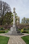 More images |
| Gatehouse to St John's Hospital | Canterbury | Gatehouse | 16th century | 3 December 1949 | TR1520958297 51°16′59″N 1°05′05″E / 51.28314°N 1.084651°E / 51.28314; 1.084651 (Gatehouse to St John's Hospital) | 1260716 |  |
| House of Agnes Hotel | Canterbury | Timber-framed house | 16th century | 3 December 1949 | TR1444558179 51°16′57″N 1°04′25″E / 51.282368°N 1.073642°E / 51.282368; 1.073642 (House of Agnes Hotel) | 1260281 |  More images |
| King's Bridge | Canterbury | Bridge | Medieval | 7 September 1973 | TR1478657930 51°16′48″N 1°04′42″E / 51.280004°N 1.078374°E / 51.280004; 1.078374 (King's Bridge) | 1085029 | 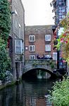 More images |
| Lullingstone House | Canterbury | House | Early 18th century | 3 December 1949 | TR1474957612 51°16′38″N 1°04′40″E / 51.277163°N 1.077654°E / 51.277163; 1.077654 (Lullingstone House) | 1085090 |  |
| Manwood's Hospital | Hackington, Canterbury | Almshouse | 1570 | 3 December 1949 | TR1470059134 51°17′27″N 1°04′40″E / 51.290847°N 1.077866°E / 51.290847; 1.077866 (Manwood's Hospital) | 1374126 |  |
| Number 77 (part of the Rose and Crown Inn), Nos 78 & 79, St Dunstans St | Canterbury | House | 16th century | 3 December 1949 | TR1447958155 51°16′56″N 1°04′27″E / 51.28214°N 1.074114°E / 51.28214; 1.074114 (Number 77 (part of the Rose and Crown Inn), Nos 78 & 79, St Dunstans St) | 1241876 |  More images |
| Old Huguenot Weaver's House | Canterbury | Timber-framed house | 16th century | 3 December 1949 | TR1501358102 51°16′53″N 1°04′54″E / 51.281463°N 1.081727°E / 51.281463; 1.081727 (Old Huguenot Weaver's House) | 1241442 |  More images |
| Queen Elizabeth's Guest Chamber | Canterbury | Inn | Late 16th century | 3 December 1949 | TR1489357817 51°16′44″N 1°04′47″E / 51.278949°N 1.079838°E / 51.278949; 1.079838 (Queen Elizabeth's Guest Chamber) | 1260873 |  More images |
| Refectory Hall and Kitchen to St John's Hospital | Canterbury | Kitchen | 12th century | 3 December 1949 | TR1515858333 51°17′01″N 1°05′02″E / 51.283482°N 1.083942°E / 51.283482; 1.083942 (Refectory Hall and Kitchen to St John's Hospital) | 1260717 |  |
| St Radigund Hall | St Radigun's, Canterbury | Wealden house | 15th century | 3 December 1949 | TR1506958206 51°16′57″N 1°04′57″E / 51.282375°N 1.082592°E / 51.282375; 1.082592 (St Radigund Hall) | 1336812 |  |
| The Hoystings | Canterbury | House | Early 18th century | 3 December 1949 | TR1525057206 51°16′24″N 1°05′04″E / 51.273328°N 1.084581°E / 51.273328; 1.084581 (The Hoystings) | 1260634 | 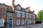 |
| The King's School Shop | Canterbury | Timber-framed house | 16th century | 3 December 1949 | TR1502358122 51°16′54″N 1°04′55″E / 51.281638°N 1.081883°E / 51.281638; 1.081883 (The King's School Shop) | 1241614 | 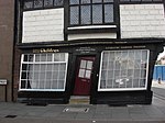 More images |
| The Presbytery | Canterbury | House | 18th century | 3 December 1949 | TR1513957759 51°16′42″N 1°05′00″E / 51.278335°N 1.083325°E / 51.278335; 1.083325 (The Presbytery) | 1251907 |  More images |
| The Roper Gate | Canterbury | Gate | 16th century | 7 September 1973 | TR1434258284 51°17′00″N 1°04′20″E / 51.28335°N 1.07223°E / 51.28335; 1.07223 (The Roper Gate) | 1241835 | 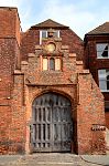 More images |
| The Weavers | Canterbury | Jettied house | 1500 | 3 December 1949 | TR1478457943 51°16′48″N 1°04′42″E / 51.280121°N 1.078353°E / 51.280121; 1.078353 (The Weavers) | 1242339 |  More images |
| Tudor House | Canterbury | House | 18th century | 3 May 1967 | TR1485157961 51°16′49″N 1°04′46″E / 51.280258°N 1.079323°E / 51.280258; 1.079323 (Tudor House) | 1085169 | 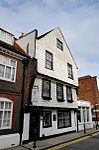 More images |
| Tyler Hill Railway Tunnel, including North and South Portals, under Tyler Hill (former Canterbury and Whitstable Railway) | Tyler Hill, Canterbury | Railway tunnel | 1826–30 | 24 December 2007 | TR1415659825 51°17′50″N 1°04′14″E / 51.297256°N 1.07049°E / 51.297256; 1.07049 (Tyler Hill Railway Tunnel, including North and South Portals, under Tyler Hill (former Canterbury and Whitstable Railway)) | 1392354 |  More images |
| Underdown House | Underdown Lane, Eddington | House | 17th century | 29 September 1951 | TR1787866959 51°21′36″N 1°07′41″E / 51.359896°N 1.128153°E / 51.359896; 1.128153 (Underdown House) | 1084951 |  More images |
| Walpole House, King's School | Canterbury | Archbishops palace | Medieval | 3 December 1949 | TR1500658007 51°16′50″N 1°04′54″E / 51.280612°N 1.08157°E / 51.280612; 1.08157 (Walpole House, King's School) | 1241505 | Upload Photo |
| Westgate House | Canterbury | House | 1750 | 3 December 1949 | TR1452558123 51°16′55″N 1°04′29″E / 51.281835°N 1.074753°E / 51.281835; 1.074753 (Westgate House) | 1241911 | 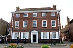 More images |
| Wincheap House | Canterbury | House | 18th century | 3 December 1949 | TR1434457218 51°16′26″N 1°04′18″E / 51.273777°N 1.07162°E / 51.273777; 1.07162 (Wincheap House) | 1258047 | 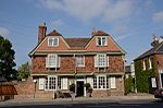 |
| 17 Cathedral Precincts | Canterbury | House | 18th century | 3 December 1949 | TR1522857950 51°16′48″N 1°05′05″E / 51.280017°N 1.084714°E / 51.280017; 1.084714 (17 Cathedral Precincts) | 1085076 |  |
| Pilgrims Entry or Pentise attached to Number 29, Cathedral Precincts | Canterbury | Cathedral precinct | Medieval | 7 September 1973 | TR1508158043 51°16′51″N 1°04′58″E / 51.280907°N 1.082666°E / 51.280907; 1.082666 (Pilgrims Entry or Pentise attached to Number 29, Cathedral Precincts) | 1085079 | Upload Photo |
| 30 Northgate | Canterbury | House | 18th century | 3 May 1967 | TR1529858369 51°17′02″N 1°05′09″E / 51.283752°N 1.085969°E / 51.283752; 1.085969 (30 Northgate) | 1096944 |  More images |
| 1 and 2 High Street | Canterbury | Inn | 14th century | 3 May 1967 | TR1494057805 51°16′44″N 1°04′50″E / 51.278824°N 1.080504°E / 51.278824; 1.080504 (1 and 2 High Street) | 1240669 |  More images |
| 37 Burgate | Canterbury | House | 18th century | 3 December 1949 | TR1499157856 51°16′45″N 1°04′53″E / 51.279262°N 1.081265°E / 51.279262; 1.081265 (37 Burgate) | 1262580 |  More images |
| 40 Burgate | Canterbury | House | Late 14th century | 3 December 1949 | TR1499957820 51°16′44″N 1°04′53″E / 51.278936°N 1.081357°E / 51.278936; 1.081357 (40 Burgate) | 1251875 |  |
| 41 Burgate | Canterbury | Timber-framed house | Late 14th century | 3 December 1949 | TR1500457831 51°16′45″N 1°04′53″E / 51.279033°N 1.081436°E / 51.279033; 1.081436 (41 Burgate) | 1085121 | 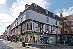 More images |
| 42 Burgate | Canterbury | Timber-framed house | Late 14th century | 3 December 1949 | TR1500957829 51°16′44″N 1°04′53″E / 51.279013°N 1.081506°E / 51.279013; 1.081506 (42 Burgate) | 1336773 |  More images |
| 43 Burgate | Canterbury | Timber-framed house | Late 14th century | 3 December 1949 | TR1501557827 51°16′44″N 1°04′54″E / 51.278993°N 1.081591°E / 51.278993; 1.081591 (43 Burgate) | 1251891 |  More images |
| 62 Burgate | Canterbury | House | Early 18th century | 3 December 1949 | TR1517157744 51°16′41″N 1°05′02″E / 51.278189°N 1.083774°E / 51.278189; 1.083774 (62 Burgate) | 1336774 | 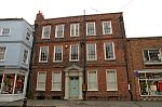 |
| 3 Best Lane | Canterbury | House | 18th century | 3 May 1967 | TR1486557980 51°16′50″N 1°04′46″E / 51.280423°N 1.079535°E / 51.280423; 1.079535 (3 Best Lane) | 1085167 | 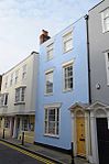 |
| 4 Best Lane | Canterbury | House | 18th century | 3 May 1967 | TR1486357976 51°16′49″N 1°04′46″E / 51.280388°N 1.079504°E / 51.280388; 1.079504 (4 Best Lane) | 1336756 |  |
| 2 Castle Street | Canterbury | Town house | 18th century | 3 May 1967 | TR1476457626 51°16′38″N 1°04′40″E / 51.277283°N 1.077877°E / 51.277283; 1.077877 (2 Castle Street) | 1085088 |  |
| 68 and 68a Castle Street | Canterbury | House | Early 18th century | 3 May 1967 | TR1470457600 51°16′37″N 1°04′37″E / 51.277072°N 1.077002°E / 51.277072; 1.077002 (68 and 68a Castle Street) | 1085101 |  More images |
| 69 Castle Street | Canterbury | House | 16th century | 3 May 1967 | TR1471457608 51°16′38″N 1°04′38″E / 51.27714°N 1.07715°E / 51.27714; 1.07715 (69 Castle Street) | 1252148 |  More images |
| 1–8 Mercery Lane | Canterbury | House | 14th century | 3 December 1949 | TR1495757830 51°16′45″N 1°04′51″E / 51.279042°N 1.080762°E / 51.279042; 1.080762 (1–8 Mercery Lane) | 1097028 |  More images |
| 42–45 Ivy Lane | Canterbury | Wealden house | 15th century | 3 December 1949 | TR1538357600 51°16′37″N 1°05′12″E / 51.276816°N 1.086722°E / 51.276816; 1.086722 (42–45 Ivy Lane) | 1260829 |  More images |
| 8 Palace Street | Canterbury | Timber-framed house | Medieval | 3 December 1949 | TR1496157993 51°16′50″N 1°04′51″E / 51.280504°N 1.080917°E / 51.280504; 1.080917 (8 Palace Street) | 1241459 |  More images |
| 41–45 Palace Street | Canterbury | House | Medieval | 3 May 1967 | TR1501458039 51°16′51″N 1°04′54″E / 51.280897°N 1.081704°E / 51.280897; 1.081704 (41–45 Palace Street) | 1241616 |  More images |
| 16 Watling Street | Canterbury | House | Early 18th century | 3 December 1949 | TR1485857592 51°16′37″N 1°04′45″E / 51.276942°N 1.079202°E / 51.276942; 1.079202 (16 Watling Street) | 1242830 |  |
Notes
- ^ The date given is the date used by Historic England as significant for the initial building or that of an important part in the structure's description.
- ^ Sometimes known as OSGB36, the grid reference is based on the British national grid reference system used by the Ordnance Survey.
- ^ The "List Entry Number" is a unique number assigned to each listed building and scheduled monument by Historic England.
External links
![]() Media related to Grade II* listed buildings in Canterbury at Wikimedia Commons
Media related to Grade II* listed buildings in Canterbury at Wikimedia Commons
- v
- t
- e
- Bedfordshire
- Berkshire
- Bristol
- Buckinghamshire
- Cambridgeshire
- Cheshire
- Cornwall
- Cumbria
- Derbyshire
- Devon
- Dorset
- Durham
- East Sussex
- East Riding of Yorkshire
- Essex
- Gloucestershire
- Greater London
- Greater Manchester
- Hampshire
- Herefordshire
- Hertfordshire
- Isle of Wight
- Kent
- Lancashire
- Leicestershire
- Lincolnshire
- Merseyside
- Norfolk
- North Yorkshire
- Northamptonshire
- Northumberland
- Nottinghamshire
- Oxfordshire
- Rutland
- Shropshire
- Somerset
- South Yorkshire
- Staffordshire
- Suffolk
- Surrey
- Tyne and Wear
- Warwickshire
- West Midlands
- West Sussex
- West Yorkshire
- Wiltshire
- Worcestershire
- Allerdale
- Amber Valley
- Ashford
- Babergh
- Barrow-in-Furness
- Basildon
- Basingstoke and Deane
- Bath and North East Somerset
- Bolsover
- Boston
- Bournemouth
- Bradford
- Braintree
- Breckland
- Brentwood
- Brighton and Hove
- Bristol
- Broadland
- Calderdale
- Cambridge
- Camden
- Canterbury
- Carlisle
- Castle Point
- Chelmsford
- Cheltenham
- Cherwell
- Cheshire East
- Cheshire West and Chester
- Chesterfield
- Chiltern
- Christchurch
- Colchester
- Copeland
- Corby
- Cotswold
- Dartford
- Daventry
- Dover
- East Cambridgeshire
- Exeter
- Mendip
- North Somerset
- North Yorkshire (district)
- Poole
- Sedgemoor
- South Somerset
- Stoke-on-Trent
- Taunton Deane
- West Somerset
- York


