Kočna


Kočna
Slovenia
Mountain in Slovenia
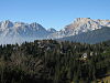
Kočna[1][2][3] at 2,540 metres (8,330 ft) high, is the second-highest mountain in the Kamnik–Savinja Alps and the westernmost peak of the Grintovec Range (Slovene: Grintovci). Its prominent and easily recognized peak is visible from far around. The mountain has two peaks: the higher Jezersko Kočna (Jezerska Kočna, 2,540 metres or 8,330 feet) and the nearby lower Kokra Kočna (Slovene: Kokrska Kočna, 2,520 metres or 8,270 feet).[1]
Name
The oronym Kočna is derived from the Slovenian common noun kočna 'cirque', referring to a valley with an amphitheater-like head and also to the valley head itself with pastures and forests below the wall of a mountain, and was applied to the mountain via metonymy. The common noun kočna itself is derived from the Slavic root *kǫtъ 'corner'. The name Kočna is also found as a settlement name for the nearby village of Kočna and in the derived name Podkočna.[4]
Starting points
- Zgornje Jezersko (889 m)
- Kamnik, Kamnik Bistrica (601 m)
- Kokra, Preddvor
Routes

- 4½-5h: from Kokra: the Suhadolnik Route
- 3¼h: from the Czech Lodge at Spodnje Ravni (Slovene: Češka koča na Spodnjih Ravneh; 1542 m): the Kremžar Route
- 3½h: from the Zois Lodge at Kokra Saddle (Slovene: Cojzova koča na Kokrskem sedlu; 1793 m)
- 1¾h: from the top of Mount Grintovec: the Šprem Route
References
External links
Wikimedia Commons has media related to Kočna.
- Mount Kočna on Geopedia
- Jezersko Kočna Route Description and Photos. Hribi.net.
- v
- t
- e
- Brana
- Carinthia Mount Rinka
- Cold Mountain (Mrzla gora)
- Grintovec
- Kalce Ridge
- Kočna
- Krofička
- Ojstrica
- Planjava
- Skuta
- Storžič