Kozienice Landscape Park
Landscape park in east-central Poland
You can help expand this article with text translated from the corresponding article in Polish. Click [show] for important translation instructions.
- Machine translation, like DeepL or Google Translate, is a useful starting point for translations, but translators must revise errors as necessary and confirm that the translation is accurate, rather than simply copy-pasting machine-translated text into the English Wikipedia.
- Consider adding a topic to this template: there are already 294 articles in the main category, and specifying
|topic=will aid in categorization. - Do not translate text that appears unreliable or low-quality. If possible, verify the text with references provided in the foreign-language article.
- You must provide copyright attribution in the edit summary accompanying your translation by providing an interlanguage link to the source of your translation. A model attribution edit summary is
Content in this edit is translated from the existing Polish Wikipedia article at [[:pl:Kozienicki Park Krajobrazowy]]; see its history for attribution. - You may also add the template
{{Translated|pl|Kozienicki Park Krajobrazowy}}to the talk page. - For more guidance, see Wikipedia:Translation.
| Kozienice Landscape Park | |
|---|---|
| Kozienicki Park Krajobrazowy | |
IUCN category V (protected landscape/seascape) | |
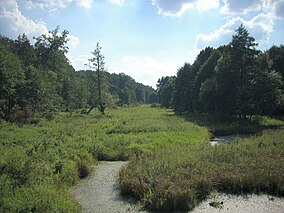 Zagożdżonka river marshes at the Park | |
| Location | Masovian Voivodeship |
| Area | 262.33 km2 |
| Established | 1983 |
Kozienice Landscape Park (Polish: Kozienicki Park Krajobrazowy) is a protected area (Landscape Park) in east-central Poland, established in 1983, covering an area of 262.33 square kilometres (101.29 sq mi).[1]
The Park lies within Masovian Voivodeship. It takes its name from the town of Kozienice.
Kozienice nature reserves
Within the Landscape Park are 15 nature reserves of importance for wildlife, flora, and fauna, including: Zagożdżon (65.67 ha), Ponty im. T. Zielińskiego (36.61 ha), Brzeźniczka (122.48 ha), Załamanek (78.97 ha), Pionki (81.60 ha), Ciszek (40.28 ha), Jedlnia (86.42 ha), Miodne (20.38 ha), Ługi Helenowskie (93.56 ha), Krępiec (278.96 ha), Ponty Dęby (50.40 ha), Leniwa (26.89 ha), Źródło Królewskie (29.67 ha), Okólny Ług (168.94 ha), and Guść (87.09 ha).[1]
References
- ^ a b Oficjalna strona Kozienickiego Parku Krajobrazowego Archived 2014-03-06 at the Wayback Machine (official webpage).
- v
- t
- e
- Smallcaps indicate World Heritage Sites
- Italics indicate Biosphere reserves
- Babia Góra
- Białowieża
- Biebrza
- Bieszczady
- Bory Tucholskie
- Drawa
- Gorce
- Kampinos
- Karkonosze
- Magura
- Narew
- Ojców
- Pieniny
- Polesie
- Roztocze
- Slovincian
- Świętokrzyski
- Stołowe Mountains
- Tatra
- Ujście Warty
- Wielkopolska
- Wigry
- Wolin
- Biosphere reserves
- Landscape parks (Parki Krajobrazowe)
- Nature reserves (Rezerwaty przyrody)
- Ramsar sites
- World Heritage Sites
| Authority control databases |
|
|---|
51°27′43″N 21°35′09″E / 51.461927°N 21.585839°E / 51.461927; 21.585839


