Lavnin (Hurvat Libnah / Tel Lavnin / Kh. Tell el-Beida)(Hebrew: חורבת לבנין)(Arabic: خربة تل البيضة), is a late Bronze Age archaeological site situated in Israel's Adullam region, rising some 389 metres (1,276 ft) above sea level. The site lies 8 kilometres (5.0 mi) northwest of Beit Gubrin, and about 1 kilometer west-north-west of Khirbat Umm Burj, directly south of Nehusha.
In April 2019, the Jerusalem District Planning and Building Committee announced that the site would be incorporated into a new national park in the Judean Shephelah, called the "Lavnin Ridge Nature Reserve and National Park," an area to span over 1,000 dunams (250 acres) within the Mateh Yehuda Regional Council.[1]
Etymology and identification
The name Lavnin is a reflection of popular etymology, the modern Hebrew name being a translation of the Arabic word Beida, meaning "white."[2] Others say that its modern name represents "the hill of bricks," hence: Tell Livnin (livanim), based on a different pronunciation of the Hebrew that is typically written without vowels.[3] Archaeologists are divided as to the site's original name, some holding the view that it may have been the biblical Libnah (Joshua 15:42; 21:13)[4] based on its Arabic name, while others thought it to have been the Chezib of Judah,[5] or the Azekah (Joshua 10:10-11[6]) mentioned by Epiphanius.[3]
Depending on whether the site was the same as Lobana, as described by Eusebius in his Onomasticon as "now being a village in Eleutheropolitana" (in the vicinity of Beit Gubrin), the town would have still been settled and occupied as late as the 4th-century CE.[7] Archaeologist Boaz Zissu rejects the notion that the site could have been Chezib of Judah, saying that "since Khirbet Tell el-Bēḍā / Tel Lavnīn was clearly occupied during the Byzantine Period, it is questionable whether this site is the same as Eusebius’ ruined Chasbi."[8] Others proposed that Libnah may be the ruin known as Tell eṣ-Ṣāfi,[9] a view now largely rejected.[10] Travellers C.W.M. van de Velde and H.B. Tristram both placed the ancient ruin of Libnah at the ruin called ʻIrâq el-Menshiyeh, where Kiryat Gat now stands;[11] this view is also now largely rejected.
Lt. Col. Conder of the Palestine Exploration Fund professed to be uncertain about the site of the biblical Libnah, and was equally unfamiliar with the connection between the Arabic name el-Beida and Libnah (= "white"), although acknowledging that "it (Libnah) indicates the 'white' chalk of the Southern Shephelah, and it was taken by Joshua (Joshua 10:30) after Makkedah and before Lachish and Hebron."[12]
During an archaeological survey of the site in 1998, Israel Antiquities Authority archaeologist Boaz Zissu described what appeared to be a "lion's den" at Tel Lavnin (having a side-entrance and an observation point from above), a Second Temple period ritual bath (mikveh), burial tombs from the same period, fortifications, and Byzantine era graffiti on the walls.[15]
In 2001, Zissu, on behalf of the IAA, conducted a second survey of the site,[16] which abounds with burial caves, and contains a columbarium, along with water cisterns carved into the bedrock. A decorated lintel rests at the top of the hill. A small area containing two pits and a room with an arched vault built of ashlar stones was exposed in the northeastern part.
^Avraham Negev & Shimon Gibson (2001), p. 16 (s.v. Achzib [a]); A. F. Rainey (1983), p. 5; Pinhas Ne'eman, ed. (1963–1966), s.v. כזיב; F. M. Abel, Géogr. II, p. 237; ZDPV 1934, p. 124.
^"Bible Gateway passage: Joshua 10:10-11 - New King James Version". Bible Gateway. Retrieved 2023-08-02.
^Chapmann III, R.L.; et al. (2003), p. 68, s.v. Lebna
Klein, Eitan; Shai, Itzhaq (2016). "Burial Caves from the Late Bronze and Iron Ages at Horvat Lavnin in the Judean Shephelah". Tel Aviv. Journal of the Institute of Archaeology of Tel Aviv University. 43 (2): 221–238. doi:10.1080/03344355.2016.1215554. S2CID 133071420.
Bibliography
Albright, W.F. (1921–22). "Contribution to the Historical Geography of Palestine". The Annual of the American Schools of Oriental Research. 2–3. New Haven: Yale University Press: 1–46. doi:10.2307/3768450. JSTOR 3768450.
Chapmann III, R.L.; Taylor, J.E., eds. (2003). Palestine in the Fourth Century A.D.: The Onomasticon by Eusebius of Caesarea. Translated by G.S.P. Freeman-Grenville. Jerusalem: Carta. p. 68. ISBN 965-220-500-1. OCLC 937002750., s.v. Lebna
Hawk, L. Daniel (2010). Joshua in 3-D: A Commentary on Biblical Conquest and Manifest Destiny. Eugene, Ore.: Cascade Books. p. 126. ISBN 9781606088197. OCLC 636959402.
Kallai-Kleinmann, Z. (1958). "The Town Lists of Judah, Simeon, Benjamin and Dan". Vetus Testamentum. 8 (2). Leiden: Brill: 134–160. doi:10.2307/1516086. JSTOR 1516086.
Ne'eman, Pinhas, ed. (1963–1966), "כזיב", Encyclopedia of Biblical Geography, Tel Aviv: Yehoshua Tchechik
Negev, Avraham; Gibson, Shimon (2001). Archaeological Encyclopedia of the Holy Land. New York. ISBN 978-0-8264-1316-1.{{cite book}}: CS1 maint: location missing publisher (link)
Notley, R. Steven; Safrai, Z. (2005). Eusebius, Onomasticon - The Place Names of Divine Scripture. Leiden: Brill. ISBN 978-0-391-04217-9.
Palmer, E.H. (1881). The Survey of Western Palestine: Arabic and English Name Lists Collected During the Survey by Lieutenants Conder and Kitchener, R. E. Transliterated and Explained by E.H. Palmer. Committee of the Palestine Exploration Fund.
Press, Michael D. (2014). "The Arabic Names of Tẹ̄l ʿẸ̄rānī and ʿIrāq el-Menšīye". Zeitschrift des Deutschen Palästina-Vereins. 130 (2). Deutscher verein zur Erforschung Palästinas: 181–193. JSTOR 43664932.
Rainey, A.F. (1983). "The Biblical Shephelah of Judah". Bulletin of the American Schools of Oriental Research (251): 1–22. doi:10.2307/1356823. JSTOR 1356823. S2CID 163604987.
Zissu, Boaz [in Hebrew]; Ganor, Amir (2008). "Survey and Excavations at Ḥorbat Burgin in the Judean Shephelah: Burial Caves, Hiding Complexes and Installations of the Second Temple and Byzantine Periods". 'Atiqot. 58: 60–64. JSTOR 23464336.
Zissu, Boaz [in Hebrew] (1999). "Daniel in the Lion's Den (?) at Tel Lavnin, Judaean Shefelah". Revue Biblique (in French). 106 (4). Jerusalem: 563–573. JSTOR i40170804.
Zissu, Boaz [in Hebrew]; Gass, Erasmus (2011), "The Identification of Biblical Achzib at Khirbet ʿĒn el-Kizbe in the Judean Shephelah, and the Origins of Shimon Bar Kokhba", 'Go Out and Study the Land' (Judges 18:2), Leiden: Brill, doi:10.1163/9789004214132_023, ISBN 9789004214132
External links
Survey of Western Palestine, Map 21: IAA, Wikimedia commons


 History portal
 Israel portal
 Deep cistern at the Lavnin ruin
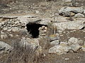 Cave entrance at Lavnin
 Open pit at the Lavnin ruins
 Gaping hole of pit
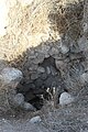 General ruins at Lavnin (Kh. Tell el-Beida)
 Stone relics at Lavnin ruin
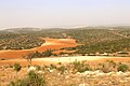 View of valley below Kh. Tell el-Beida
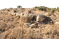 Wall structure at Lavnin
 Hilltop ruin of Tell el-Beida (Lavnin)


