List of bridges on the National Register of Historic Places in Oregon
Map all coordinates using OpenStreetMap
Download coordinates as:
- KML
- GPX (all coordinates)
- GPX (primary coordinates)
- GPX (secondary coordinates)
This is a list of bridges and tunnels on the National Register of Historic Places in the U.S. state of Oregon. It includes a number of viaducts which are considered bridges. A list of bridges, tunnels, and viaducts of the Historic Columbia River Highway is included.
Gray shading indicates that a structure has been removed from the Register. Often the road listed in the "location" column now parallels the bridge on a new one, and the old bridge is closed to traffic.
Map all coordinates using OpenStreetMap
Download coordinates as:
- KML
- GPX (all coordinates)
- GPX (primary coordinates)
- GPX (secondary coordinates)
Bridges and tunnels besides in Historic Columbia River Highway
| Name | Image | Built | Listed | Location | County | Type |
|---|---|---|---|---|---|---|
| Antelope Creek Bridge |  | 1922 | 1979-11-29 removed 1988-04-18 but re-added in 2012 | Main Street over Little Butte Creek, Eagle Point 42°28′19″N 122°48′00″W / 42.472°N 122.800°W / 42.472; -122.800 (Antelope Creek Bridge) (moved from Antelope Creek, a nearby tributary of Little Butte Creek) | Jackson | Covered modified queenpost truss |
| Belknap Bridge | 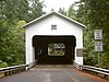 | 1966 | 1979-11-29 | McKenzie River, Rainbow 44°10′05″N 122°13′41″W / 44.168°N 122.228°W / 44.168; -122.228 (Belknap Bridge) | Lane | Covered Howe truss |
| Big Creek Bridge No. 01180 |  | 1931 | 2005-08-05 | US 101 over Big Creek, north of Florence 44°10′26″N 124°06′54″W / 44.174°N 124.115°W / 44.174; -124.115 (Big Creek Bridge) | Lane | Bowstring arch |
| Broadway Bridge |  | 1913 | 2012-11-14 | Willamette R. at RM 11.7, Portland 45°31′55″N 122°40′26″W / 45.531816°N 122.673898°W / 45.531816; -122.673898 (Broadway Bridge) | Multnomah | Willamette River Highway Bridges of Portland, Oregon MPS |
| Burnside Bridge |  | 1926 | 2012-11-14 | Willamette R. at RM 12.7, Portland 45°31′23″N 122°40′03″W / 45.523037°N 122.667632°W / 45.523037; -122.667632 (Broadway Bridge) | Multnomah | Willamette River Highway Bridges of Portland, Oregon MPS |
| Cape Creek Bridge No. 01113 | 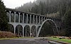 | 1932 | 2005-08-05 | US 101 over Cape Creek, north of Florence 44°07′59″N 124°07′19″W / 44.133°N 124.122°W / 44.133; -124.122 (Cape Creek Bridge) | Lane | Arch |
| Chambers Bridge |  | 1936 | 1979-11-29 | Tyler Avenue over Coast Fork Willamette River, Cottage Grove 43°47′20″N 123°04′12″W / 43.789°N 123.070°W / 43.789; -123.070 (Chambers Bridge) | Lane | Covered Howe truss |
| Chitwood Bridge | 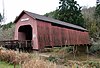 | ca. 1930 | 1979-11-29 | Chitwood Road over Yaquina River, Chitwood 44°39′14″N 123°49′05″W / 44.654°N 123.818°W / 44.654; -123.818 (Chitwood Bridge) | Lincoln | Covered Howe truss |
| Coos Bay Bridge No. 01823 |  | 1936 | 2005-08-05 | US 101 over Coos Bay, North Bend 43°25′34″N 124°13′19″W / 43.426°N 124.222°W / 43.426; -124.222 (Coos Bay Bridge) | Coos | Cantilever |
| Coyote Creek Bridge |  | 1922 | 1979-11-29 | Coyote Creek Road over Coyote Creek, south of Crow 43°58′12″N 123°19′08″W / 43.970°N 123.319°W / 43.970; -123.319 (Coyote Creek Bridge) | Lane | Covered Howe truss |
| Crawfordsville Bridge |  | 1932 | 1979-11-29 | OR 228 over Calapooia River, Crawfordsville 44°21′29″N 122°51′36″W / 44.358°N 122.860°W / 44.358; -122.860 (Crawfordsville Bridge) | Linn | Covered Howe truss |
| Currin Bridge |  | 1925 | 1979-11-29 | Layng Road over Row River, east of Cottage Grove 43°47′35″N 122°59′46″W / 43.793°N 122.996°W / 43.793; -122.996 (Currin Bridge) | Lane | Covered Howe truss |
| Deadwood Creek Bridge |  | 1932 | 1979-11-29 | Deadwood Loop over Deadwood Creek, north of Deadwood 44°08′38″N 123°43′12″W / 44.144°N 123.720°W / 44.144; -123.720 (Deadwood Creek Bridge) | Lane | Covered Howe truss |
| Depoe Bay Bridge No. 01388 |  | 1927 | 2005-08-05 | US 101 over Depoe Bay, Depoe Bay 44°48′36″N 124°03′43″W / 44.810°N 124.062°W / 44.810; -124.062 (Depoe Bay Bridge) | Lincoln | Arch |
| Dorena Bridge |  | 1949 | 1979-11-29 | Shoreview Drive over Row River, north of Dorena 43°44′13″N 122°53′02″W / 43.737°N 122.884°W / 43.737; -122.884 (Dorena Bridge) | Lane | Covered Howe truss |
| Earnest Bridge |  | 1938 | 1979-11-29 | Paschelke Road over Mohawk River, north of Marcola 44°12′04″N 122°50′10″W / 44.201°N 122.836°W / 44.201; -122.836 (Ernest Bridge) | Lane | Covered Howe truss |
| Fisher School Bridge | 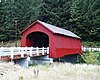 | 1925 | 1979-11-29 | East Crab Creek Road over Five Rivers, Fisher 44°17′31″N 123°50′28″W / 44.292°N 123.841°W / 44.292; -123.841 (Fisher School Bridge) | Lincoln | Covered Howe truss |
| Gallon House Bridge |  | 1916 | 1979-11-29 | Gallon House Road over Abiqua Creek, northwest of Silverton 45°01′55″N 122°47′53″W / 45.032°N 122.798°W / 45.032; -122.798 (Gallon House Bridge) | Marion | Covered Howe truss |
| Goodpasture Bridge |  | 1938 | 1979-11-29 | Goodpasture Road over McKenzie River, west of Vida 44°08′53″N 122°35′17″W / 44.148°N 122.588°W / 44.148; -122.588 (Goodpasture Bridge) | Lane | Covered Howe truss |
| Grave Creek Bridge |  | 1920 | 1979-11-29 | Sunny Valley Loop over Grave Creek, Sunny Valley 42°38′10″N 123°22′41″W / 42.636°N 123.378°W / 42.636; -123.378 (Grave Creek Bridge) | Josephine | Covered Howe truss |
| Hannah Bridge |  | 1936 | 1979-11-29 | Camp Morrison Drive over Thomas Creek, east of Scio 44°42′43″N 122°43′08″W / 44.712°N 122.719°W / 44.712; -122.719 (Hannah Bridge) | Linn | Covered Howe truss |
| Harris Bridge |  | 1936 | 1979-11-29 | Harris Road over Marys River, Harris 44°34′48″N 123°27′36″W / 44.580°N 123.460°W / 44.580; -123.460 (Harris Bridge) | Benton | Covered Howe truss |
| Hawthorne Bridge |  | 1910 | 2012-11-14 | Willamette R. at RM 13.1, Portland 45°30′48″N 122°40′15″W / 45.513204°N 122.670937°W / 45.513204; -122.670937 (Hawthorne Bridge) | Multnomah | Willamette River Highway Bridges of Portland, Oregon MPS |
| Hayden Bridge |  | 1918 | 1979-11-29 | Hayden Road over Alsea River, west of Alsea 44°22′59″N 123°37′52″W / 44.383°N 123.631°W / 44.383; -123.631 (Hayden Bridge) | Benton | Covered Howe truss |
| Hoffman Bridge |  | 1936 | 1987-02-17 | Hungry Hill Road over Crabtree Creek, north of Crabtree 44°39′11″N 122°53′24″W / 44.653°N 122.890°W / 44.653; -122.890 (Hoffman Bridge) | Linn | Covered Howe truss |
| Irish Bend Bridge |  | 1954 | 2013-03-27 | Campus Way over Oak Creek, Corvallis 44°34′01″N 123°18′04″W / 44.567°N 123.301°W / 44.567; -123.301 (Irish Bend Bridge) (moved from Irish Bend Road northeast of Monroe) | Benton | Covered Howe truss |
| Lake Creek Bridge |  | 1928 | 1979-11-29 | Chickahominy Road over Lake Creek, south of Greenleaf 44°06′14″N 123°40′26″W / 44.104°N 123.674°W / 44.104; -123.674 (Lake Creek Bridge) | Lane | Covered Howe truss |
| Larwood Bridge |  | 1939 | 1979-11-29 | Fish Hatchery Drive over Crabtree Creek, Larwood 44°37′48″N 122°44′28″W / 44.630°N 122.741°W / 44.630; -122.741 (Larwood Bridge) | Linn | Covered Howe truss |
| Longview Bridge |  | 1929, 1930 | 1982-07-16 | Columbia River, Rainier 46°06′18″N 122°57′43″W / 46.105°N 122.962°W / 46.105; -122.962 (Longview Bridge) | Columbia | Cantilever bridge |
| Lost Creek Bridge |  | 1919 | 1979-11-29 | Lost Creek Road over Lost Creek, southeast of Lake Creek 42°22′48″N 122°34′48″W / 42.380°N 122.580°W / 42.380; -122.580 (Lost Creek Bridge) | Jackson | Covered modified queenpost truss |
| Lowell Bridge | 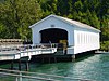 | 1945, 1947, 1953 | 1979-11-29 | Pioneer Street over Dexter Lake, south of Lowell 43°54′32″N 122°46′44″W / 43.909°N 122.779°W / 43.909; -122.779 (Lowell Bridge) | Lane | Covered Howe truss |
| McKee Bridge |  | 1917 | 1979-11-29 | McKee Branch Road over Applegate River, south of Ruch 42°07′34″N 123°04′23″W / 42.126°N 123.073°W / 42.126; -123.073 (McKee Bridge) | Jackson | Covered Howe truss |
| Milo Academy Bridge |  | 1962 | 1979-11-29 | Milo Drive over South Umpqua River, Milo 42°56′06″N 123°02′20″W / 42.935°N 123.039°W / 42.935; -123.039 (Milo Academy Bridge) | Douglas | Covered |
| Morrison Bridge |  | 1958 | 2012-11-14 | Willamette R. at RM 12.8, Portland 45°30′48″N 122°40′15″W / 45.513204°N 122.670937°W / 45.513204; -122.670937 (Hawthorne Bridge) | Multnomah | Willamette River Highway Bridges of Portland, Oregon MPS |
| Mosby Creek Bridge | 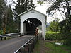 | 1920 | 1979-11-29 | Layng Road over Mosby Creek, east of Cottage Grove 43°46′41″N 123°00′18″W / 43.778°N 123.005°W / 43.778; -123.005 (Mosby Creek Bridge) | Lane | Covered Howe truss |
| North Fork of the Yachats Bridge |  | 1938 | 1979-11-29 | North Yachats River Road over North Fork Yachats River, east of Yachats 44°18′36″N 123°58′12″W / 44.310°N 123.97°W / 44.310; -123.97 (North Fork of the Yachats Bridge) | Lincoln | Covered queenpost truss |
| Office Bridge |  | 1944 | 1979-11-29 | Westoak Road over North Fork Middle Fork Willamette River, Westfir 43°45′29″N 122°29′46″W / 43.758°N 122.496°W / 43.758; -122.496 (Office Bridge) | Lane | Covered Howe truss |
| Oregon Railway and Navigation Company Bridge |  | 1887, 1907 | 1980-03-13 | McKenzie River south of Coburg 44°06′47″N 123°02′49″W / 44.113°N 123.047°W / 44.113; -123.047 (Oregon Railway and Navigation Company Bridge) | Lane | Pratt through truss |
| Parvin Bridge |  | 1921 | 1979-11-29 | Parvin Road over Lost Creek, south of Dexter 43°53′56″N 122°49′23″W / 43.899°N 122.823°W / 43.899; -122.823 (Parvin Bridge) | Lane | Covered Howe truss |
| Pengra Bridge |  | 1938 | 1979-11-29 | Place Road over Fall Creek, southeast of Jasper 43°57′58″N 122°50′42″W / 43.966°N 122.845°W / 43.966; -122.845 (Pengra Bridge) | Lane | Covered Howe truss |
| Portland and Southwestern Railroad Tunnel |  | 1910, 1920, 1921 | 1981-08-17 | Proposed Crown Zellerbach Trail, west of Chapman 45°49′59″N 123°02′49″W / 45.833°N 123.047°W / 45.833; -123.047 (Portland and Southwestern Railroad Tunnel) | Columbia | |
| Portland–Vancouver Highway Bridge (Interstate Bridge) |  | 1915–1917 | 1982-07-16 | I-5 over Columbia River, north of Portland 45°37′12″N 122°40′26″W / 45.620°N 122.674°W / 45.620; -122.674 (Vancouver-Portland Bridge) | Multnomah | Steel truss with vertical-lift section |
| Ritner Creek Bridge |  | 1927, 1976 | 1979-11-29 | OR 223 over Ritner Creek, Ritner 44°43′41″N 123°26′31″W / 44.728°N 123.442°W / 44.728; -123.442 (Ritner Creek Bridge) | Polk | Covered Howe truss |
| Rock O' the Range Bridge |  | 1963 | 1979-11-29 | Bowery Lane over Swalley Canal, north of Bend 44°07′19″N 121°17′13″W / 44.122°N 121.287°W / 44.122; -121.287 (Rock O' the Range Bridge) | Deschutes | Covered king post truss |
| Rocky Creek Bridge No. 01089 |  | 1927 | 2005-08-05 | Otter Crest Loop Road (old US 101) over Rocky Creek, south of Depoe Bay 44°46′41″N 124°04′19″W / 44.778°N 124.072°W / 44.778; -124.072 (Rocky Creek Bridge) | Lincoln | |
| Rogue River Bridge No. 01172 |  | 1932 | 2005-08-05 | US 101 over Rogue River, Gold Beach 42°25′37″N 124°24′47″W / 42.427°N 124.413°W / 42.427; -124.413 (Rogue River Bridge) | Curry | |
| Sandy Creek Bridge | 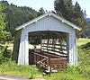 | 1921 | 1979-11-29 | OR 42 over Sandy Creek, Remote 43°00′22″N 123°53′31″W / 43.006°N 123.892°W / 43.006; -123.892 (Sandy Creek Bridge) | Coos | Covered Howe truss |
| Short Bridge |  | 1945 | 1979-11-29 | High Deck Road over Santiam River, west of Cascadia 44°23′31″N 122°30′36″W / 44.392°N 122.510°W / 44.392; -122.510 (Short Bridge) | Linn | Covered Howe truss |
| Siuslaw River Bridge No. 01821 |  | 1936 | 2005-08-05 | US 101 over Siuslaw River, Florence 43°57′54″N 124°06′32″W / 43.965°N 124.109°W / 43.965; -124.109 (Siuslaw River Bridge) | Lane | Bascule |
| Stewart Bridge |  | 1930 | 1979-11-29 | Garoutte Road over Mosby Creek, southeast of Walden 43°45′58″N 122°59′38″W / 43.766°N 122.994°W / 43.766; -122.994 (Stewart Bridge) | Lane | Covered Howe truss |
| Stone Bridge and the Oregon Central Military Wagon Road |  | 1867, 1872 | 1974-11-08 | Warner Valley, southeast of Plush 42°21′18″N 119°50′28″W / 42.355°N 119.841°W / 42.355; -119.841 (Stone Bridge) | Lake | Primitive causeway |
| Ten Mile Creek Bridge No. 01181 |  | 1931 | 2005-08-05 | US 101 over Tenmile Creek, south of Yachats 44°13′26″N 124°06′36″W / 44.224°N 124.110°W / 44.224; -124.110 (Ten Mile Creek Bridge) | Lane | Tied arch |
| Thomas Creek-Gilkey Covered Bridge |  | 1939 | 1987-02-19 | Goar Road over Thomas Creek, north of Crabtree 44°41′17″N 122°54′11″W / 44.688°N 122.903°W / 44.688; -122.903 (Gilkey Bridge) | Linn | Covered Howe truss |
| Thomas Creek-Shimanek Covered Bridge | 1966 | 1987-02-19 | Richardson Gap Road over Thomas Creek, northeast of Scio 44°42′58″N 122°48′14″W / 44.716°N 122.804°W / 44.716; -122.804 (Shimanek Bridge) | Linn | Covered Howe truss | |
| Umpqua River Bridge No. 01822 |  | 1936 | 2005-08-05 | US 101 over Umpqua River, Reedsport 43°42′36″N 124°06′04″W / 43.710°N 124.101°W / 43.710; -124.101 (Umpqua River Bridge) | Douglas | |
| Union Street Railroad Bridge and Trestle |  | 1913 | 2006-01-11 | Willamette River, Salem 44°56′49″N 123°02′31″W / 44.947°N 123.042°W / 44.947; -123.042 (Union Street Railroad Bridge) | Marion | Pratt through truss |
| Unity Bridge |  | 1936, 1975 | 1979-11-29 | Unity–Lowell Road over Fall Creek, Unity 43°56′42″N 122°46′30″W / 43.945°N 122.775°W / 43.945; -122.775 (Unity Bridge) | Lane | Covered Howe truss |
| Vista Avenue Viaduct |  | 1926 | 1984-04-26 | Vista Avenue over Canyon Road, Portland 45°31′08″N 122°41′53″W / 45.519°N 122.698°W / 45.519; -122.698 (Vista Avenue Viaduct) | Multnomah | |
| Wendling Bridge |  | 1938 | 1979-11-29 | Wendling Road over Mill Creek, Wendling 44°11′28″N 122°47′56″W / 44.191°N 122.799°W / 44.191; -122.799 (Wendling Bridge) | Lane | Covered Howe truss |
| Wildcat Creek Bridge |  | 1925 | 1979-11-29 | Richardson Upriver Road over Wildcat Creek, Walton 44°00′11″N 123°39′18″W / 44.003°N 123.655°W / 44.003; -123.655 (Wildcat Creek Bridge) | Lane | Covered Howe truss |
| Willamette River (Oregon City) Bridge (No. 357) |  | 1922 | 2005-07-01 | OR 43 over Willamette River, Oregon City 45°21′32″N 122°36′36″W / 45.359°N 122.610°W / 45.359; -122.610 (Oregon City Bridge) | Clackamas | Through arch |
| Wilson River Bridge No. 01499 |  | 1931 | 2005-08-05 | US 101 over Wilson River, north of Tillamook 45°28′41″N 123°50′42″W / 45.478°N 123.845°W / 45.478; -123.845 (Wilson River Bridge) | Tillamook | |
| Yaquina Bay Bridge No. 01820 |  | 1936 | 2005-08-05 | US 101 over Yaquina Bay, Newport 44°37′23″N 124°03′25″W / 44.623°N 124.057°W / 44.623; -124.057 (Yaquina Bay Bridge) | Lincoln | |
| Columbia River Highway Historic District |   | 1912–1921, 1937[1] | 1983-12-12 | Troutdale to The Dalles | Multnomah, Hood River, Wasco | Multiple bridges and tunnels: see #Historic Columbia River Highway bridges and tunnels |
| Brumbaugh Bridge | 1948, 1950 | 1979-11-29 removed 1986-11-25 | Mosby Creek, southeast of Walden (destroyed) | Lane | Covered Howe truss | |
| Drift Creek Bridge |  | 1914 | 1979-11-29 removed 1998-07-21 | Rogers Lane over Bear Creek, southeast of Otis 44°59′35″N 123°53′10″W / 44.993°N 123.886°W / 44.993; -123.886 (Drift Creek Bridge) (moved from Drift Creek Road over Drift Creek, southeast of Lincoln City) | Lincoln | Covered Howe truss |
| Elk City Bridge | 1922 | 1979-11-29 removed 1986-11-25 | Yaquina River, Elk City (destroyed) | Lincoln | Covered Howe truss | |
| Horse Creek Bridge |  | 1930 | 1979-11-29 removed 1988-06-27 | Myrtle Creek, Myrtle Creek 43°01′23″N 123°17′24″W / 43.023°N 123.290°W / 43.023; -123.290 (Horse Creek Bridge) (moved from Horse Creek Road over Horse Creek, south of McKenzie Bridge) | Lane | Covered Howe truss |
| Pumping Station Bridge |  | 1916 | 1979-11-29 removed 1987-05-18 | Rickreall Creek, southwest of Ellendale (destroyed) | Polk | Covered |
| Roaring Camp Bridge |  | 1929 | 1979-11-29 removed 1996-01-17 | Roaring Camp Lane over Elk Creek, west of Drain 43°39′50″N 123°26′24″W / 43.664°N 123.440°W / 43.664; -123.440 (Roaring Camp Bridge (destroyed)) (destroyed) | Douglas | Covered Howe truss |
| Sam's Creek Bridge | 1922 | 1979-11-29 removed 1986-11-25 | Sams Creek Road over Siletz River, east of Siletz 44°43′59″N 123°50′35″W / 44.733°N 123.843°W / 44.733; -123.843 (Sam's Creek Bridge (destroyed)) (destroyed) | Lincoln | Covered Howe truss | |
| Weddle Bridge |  | 1937 | 1979-11-29 removed 1989-01-11 | Ames Creek in Sweet Home 44°23′42″N 122°43′37″W / 44.395°N 122.727°W / 44.395; -122.727 (Weddle Bridge) (moved from Kelly Road over Thomas Creek southeast of Jefferson) | Linn | Covered Howe truss |
| Wimer Bridge |  | 1927, 1962 | 1979-11-29 removed 2006-04-18 | Covered Bridge Road over Evans Creek, Wimer 42°32′17″N 123°09′00″W / 42.538°N 123.150°W / 42.538; -123.150 (Wimer Bridge) (destroyed and rebuilt) | Jackson | Covered queenpost truss |
Historic Columbia River Highway bridges and tunnels
These are contributing structures in the Historic Columbia River Highway, which was listed on the National Register of Historic Places in 1983, and was further designated a National Historic Landmark District in 2000.[2]
| Bridge or tunnel mileage | Image | Location | Notes |
|---|---|---|---|
| Sandy River Bridge |  | 45°32′18″N 122°22′36″W / 45.53845°N 122.37664°W / 45.53845; -122.37664 (Sandy River Bridge), spans Sandy River in Troutdale | Apparently a two-span truss bridge, |
| Stark Street Bridge |  | 45°30′55″N 122°21′41″W / 45.51533°N 122.36137°W / 45.51533; -122.36137 (Stark Street Bridge), brings Start Street across Sandy River in Troutdale | Pratt Truss bridge with a 200 feet (61 m) mainspan, opened in 1915. Upstream from other Sandy River bridge. |
| Crown Point Viaduct |  | 45°32′24″N 122°14′39″W / 45.53994°N 122.24423°W / 45.53994; -122.24423 (Crown Point Viaduct), at Crown Point | Viaduct consisting of a sidewalk and retaining wall around tightly looped roadway (on ground, not elevated) around Vista House at Crown Point. The curve has a 110-foot radius, within specifications for HCRH roadways. |
| Latourell Creek Bridge |  | 45°32′19″N 122°13′08″W / 45.53868°N 122.21888°W / 45.53868; -122.21888 (Latourell Creek Bridge) spans Latourell Creek below Latourell Falls | |
| Shepperd's Dell Bridge |  | 45°32′48″N 122°11′52″W / 45.54659°N 122.19780°W / 45.54659; -122.19780 (Shepherd's Dell Bridge) | A single-span 100 feet (30 m) open spandrel reinforced-concrete ribbed deck arch. Its two sidewalks have "spindle-and-cap railings."[2] |
| Bridal Veil Falls Bridge |  | 45°33′15″N 122°10′49″W / 45.55420°N 122.18026°W / 45.55420; -122.18026 (Bridal Veil Falls Bridge) | Built in 1914, "This bridge is a skewed 100-foot reinforced-concrete deck girder span in which the solid railings serve as continuous beams. The transverse deck support members function as deck girders. Width out-to-out is 23'-2", curb-to-curb is 21 feet. The unique design allowed the bridge to span both the falls and a nearby lumber company's log flumes."[2] |
| "Cattle pass" |  | Near Bridal Veil Falls. | This cattle creep consists of a single 8-foot reinforced-concrete deck slab span. "A local landowner required construction of this Cattle Pass so that his herd could migrate to both sides of a pasture bisected by the highway's construction."[2] |
| Wahkeena Creek Bridge (and/or Wahkeena Falls Bridge?) |  | 45°34′31″N 122°07′42″W / 45.57540°N 122.12830°W / 45.57540; -122.12830 (Wahkeena Creek Bridge) crosses below Wahkeena Falls. | Built in 1914, it is a reinforced concrete simple slab span, 18 feet (5.5 m) long.[2] |
| West Multnomah Falls Viaduct |  | 45°34′38″N 122°07′17″W / 45.57710°N 122.12135°W / 45.57710; -122.12135 (West Multnomah Falls Viaduct) | "This 400-foot viaduct consists of twenty 20-foot reinforced-concrete slab spans. Two parallel rows of 16-foot square columns, 17'-6" apart, support the deck. Roadway width is about 18 feet. The structure was designed to ride along the hillside above the railroad mainline because of tight right-of-way clearances. A concrete retaining wall runs along its south elevation. The arched railings were constructed of plaster concrete and metal lath. They represent a member of the family of bridge railing designs found on the CRH."[2] Can be viewed from east-bound Interstate 84, over Benson Lake. |
| Multnomah Creek Bridge |  | 45°34′40″N 122°07′01″W / 45.57781°N 122.11708°W / 45.57781; -122.11708 (Multnomah Creek Bridge) | A 67 feet (20 m) five-ribbed spandrel bridge.[2] |
| East Multnomah Falls Viaduct |  | 45°34′45″N 122°06′42″W / 45.57920°N 122.11153°W / 45.57920; -122.11153 (East Multnomah Falls Viaduct) | Built in 1914, "This 860-foot viaduct originally consisted of forty-three 20-foot reinforced-concrete slab spans. The deck was supported by two parallel rows of 16-foot-square columns, 17'-6" apart. Roadway width is about 18 feet. To provide greater stability to the structure, the Oregon State Highway Department, in 1922, added sets of intermediate posts and transverse walls at the midpoint of each span. Like the West Multnomah Falls Viaduct, this structure rises up the hillside because of tight right-of-way clearances with the nearby railroad mainline, and has a concrete retaining wall running along its south elevation. The arched railings were constructed of plaster concrete and metal lath. They represent a member of the family of bridge railing designs found on the CRH."[2] Adjacent to, and can be seen from, Interstate 84, which built out into the Columbia River. |
| Oneonta Gorge Creek Bridge |  | 45°35′23″N 122°04′31″W / 45.58959°N 122.07541°W / 45.58959; -122.07541 (Oneonta Gorge Creek Bridge) | Note another newer bridge there appears historic too? File:Oneonta Creek Bridge 7108 - HCRH Oregon.jpg |
| Oneonta Tunnel |  | 45°35′23″N 122°04′29″W / 45.58964°N 122.07471°W / 45.58964; -122.07471 (Oneonta Tunnel) | Tunnel through cliff, where modern road swings outside cliff. Open for pedestrians only. |
| Horsetail Falls Bridge |  | 45°35′25″N 122°04′09″W / 45.59025°N 122.06923°W / 45.59025; -122.06923 (Horsetail Falls Bridge) | Built in 1914, this is a "three-span 60-foot reinforced-concrete deck girder trestle [which] is 24 feet wide and has a roadway measuring 22 feet. The curb and guardrail form an integral unit, cantilevered out from the girder. The delicate arched railing panels were constructed from plaster concrete and metal lath. They are identical to those found on the Oneonta Gorge Creek Bridge (1914) and the Multnomah Falls viaducts and represent one of the family of railing designs found on the CRH."[2] |
| McCord Creek Bridge |  | 45°36′53″N 121°59′50″W / 45.61477°N 121.99716°W / 45.61477; -121.99716 (approximate location of former McCord Creek Bridge) | Not mentioned in NHL doc.[2] Has this been replaced? Seems like it is neither of two current twin spans of Interstate 84. A small bridge brings the historic trail over McCord Creek. |
| Moffett Creek Bridge |  | 45°37′25″N 121°58′39″W / 45.62358°N 121.97755°W / 45.62358; -121.97755 (Moffett Creek Bridge) | Currently carries the southbound lanes of Interstate 84 over Moffett Creek including or near Hamilton Island Reach |
| Tanner Creek Bridge |  | 45°37′53″N 121°57′17″W / 45.63134°N 121.95466°W / 45.63134; -121.95466 (Tanner Creek Bridge) | 60 feet (18 m) girder bridge[3] Perhaps not a contributing structure of HCRH? Mentioned but not described in NHL doc.[2] |
| Toothrock Viaduct |  | 45°38′18″N 121°56′13″W / 45.63831°N 121.9369°W / 45.63831; -121.9369 (Toothrock Viaduct) | Built 1915 and partially reconstructed in 1996.[2] Appears to wind around Tooth Rock, above where later-built Toothrock Tunnel comes through. |
| Toothrock Tunnel |  | 45°38′18″N 121°56′09″W / 45.63823°N 121.93596°W / 45.63823; -121.93596 (Toothrock Tunnel) | Built in 1937, "this two-lane 827-foot tunnel was bored through Tooth Rock as part of the Bonneville Dam construction project. It originally provided a 26-foot roadway and 4-foot sidewalks. Maximum clearance was 20 feet."[2] Now carries eastbound Interstate 84. |
| Eagle Creek Viaduct | |||
| Eagle Creek Bridge |  | 45°38′28″N 121°55′42″W / 45.64108°N 121.92822°W / 45.64108; -121.92822 (Eagle Creek Bridge), spanning Eagle Creek, bypassed by modern bridges of Interstate 84. | Closed spandrel single-span arch bridge. |
| Ruckel Creek Bridge |  | Remains of a bridge. | |
| Herman Creek Bridge | |||
| Gorton Creek Bridge |  | 45°41′25″N 121°46′22″W / 45.69027°N 121.77265°W / 45.69027; -121.77265 (Gorton Creek Bridge), brings Wyeth Rd. across Gorton Creek | Not mentioned in NHL nomination. Perhaps cover in Wyeth State Park (currently a redlink) which maybe oughta redirect to Wyeth, Oregon article, to which Wyeth State Recreation Area redirects. In Google satellite view, looks possibly in Wyeth State Park, and near Wyeth Trailhead. |
| Lindsey Creek Bridge | 45°41′15″N 121°42′52″W / 45.68754°N 121.71457°W / 45.68754; -121.71457 (Lindsey Creek Bridge) | Not mentioned in NHL doc.[2] | |
| Warren Creek Bridge |  | 45°41′11″N 121°42′19″W / 45.68642°N 121.70519°W / 45.68642; -121.70519 (Warren Creek Bridge) | Not mentioned in NHL document. Is the photographed bridge a 2016 replica of the original bridge, perhaps? |
| Viento Creek Bridge | |||
| Mitchell Point Viaduct |  | Part of combo with Mitchell Point Tunnel inspired by Axenstrasse in Switzerland. Since this was removed in 1966, it was not ever NRHP-listed.[2] Is this (just) the elevated approach to the tunnel, shown in photograph labelled that way? Since this was removed in 1966, it was not ever NRHP-listed. | |
| Mitchell Point Tunnel |  | Part of combo with Mitchell Point Viaduct inspired by Axenstrasse in Switzerland. Had windows like Axelstrasse does. Since this was removed in 1966, it was not ever NRHP-listed.[2] | |
| Hood River Bridge | 45°42′29″N 121°30′20″W / 45.70796°N 121.50562°W / 45.70796; -121.50562 (Hood River Bridge), spanned the Hood River | The most expensive bridge on the Historic Columbia River Highway. A 420 feet (130 m) "three-span reinforced-concrete parabolic ribbed deck arch" bridge completed in 1918. It was dismantled in 1982 and replaced by a modern bridge. Its removal sparked historic preservation of other parts of the HCRH.[2][4][5] | |
| Rock Slide Viaduct |  | <slide>45°41′43″N 121°27′43″W / 45.69520°N 121.46193°W / 45.69520; -121.46193 (Rock Slide Viaduct)</slide> | 34 feet (10 m) reinforced-concrete viaduct built in 1924. It a masonry guard wall only on its north side.[2] |
| Mosier Twin Tunnels |  | 45°41′06″N 121°25′16″W / 45.68505°N 121.42102°W / 45.68505; -121.42102 (Mosier Twin Tunnels) | Two tunnels in quick sequence, built originally in 1920. Drilled out of a basalt outcropping with an 8.7 feet (2.7 m) radius, from the west an 81 feet (25 m) bore, then 24 feet (7.3 m) in the open, then a 288 feet (88 m) bore. East tunnel has two windows, one with a cliffside walkway to the open inbetween area. Refined and enlarged in 1921 and 1938.[2] |
| Rock Creek Bridge | 45°41′05″N 121°24′17″W / 45.68481°N 121.40478°W / 45.68481; -121.40478 (Rock Creek Bridge) | Built in 1918, a "44-foot reinforced-concrete structure consists of two 22-foot slab spans. Railings were similar to those on the Tanner Creek Bridge. Decades ago, they were removed and replaced with wooden rails. In 1996, ODOT reconstructed the original concrete railings."[2] | |
| Mosier Creek Bridge |  | 45°41′05″N 121°23′40″W / 45.68468°N 121.39443°W / 45.68468; -121.39443 (Mosier Creek Bridge) | A 110 feet (34 m) open spandrel concrete ribbed deck arch bridge with a parabolic arch form, the first of many bridges in Oregon to be designed by Conde McCullough.[2] |
| Rowena Dell Bridge | 45°40′40″N 121°18′51″W / 45.67788°N 121.31411°W / 45.67788; -121.31411 (Rowena Dell Bridge) | 20 feet (6.1 m) bridge.[2] | |
| Dry Canyon Creek Bridge |  | 45°40′53″N 121°18′13″W / 45.68136°N 121.30366°W / 45.68136; -121.30366 (Dry Canyon Creek Bridge) | |
| Chenoweth Creek Bridge |  | 45°37′54″N 121°12′59″W / 45.63156°N 121.21651°W / 45.63156; -121.21651 (Chenoweth Creek Bridge) | Built in 1920, it "is a 60-foot reinforced-concrete deck girder span consisting of three 20-foot multibeam spans. Its original reinforced-concrete parapet rails have been replaced with steel "W" rail. Chenoweth Creek Bridge marks the eastern end of the CRH Historic District."[2] |
| Mill Creek Bridge |  | 45°36′11″N 121°11′36″W / 45.60308°N 121.19347°W / 45.60308; -121.19347 (Mill Creek Bridge), W. 6th St., The Dalles | Not mentioned in NHL doc? |
See also
References
- "Oregon National Register List" (PDF). Oregon Parks and Recreation Department. June 6, 2011. Retrieved June 18, 2011. (does not include places no longer listed)
- Oregon National Register List, November 10, 2005. Retrieved June 18, 2011 (includes listed dates of removed places)
- ^ Robert W. Hadlow, Ph.D., Historian, Oregon Department of Transportation, National Historic Landmark Nomination: Columbia River Highway Archived 2008-03-27 at the Wayback Machine, February 4, 2000, pp. 17-42
- ^ a b c d e f g h i j k l m n o p q r s t u v w Robert W. Hadlow (February 4, 2000). "National Historic Landmark Nomination: Columbia River Highway / Historic Columbia River Highway". National Park Service. Retrieved January 12, 2022. With accompanying 33 photos
- ^ "Tanner Creek Bridge". OregonHikers.
- ^ "Hood River Bridge Demolition, 1982". Retrieved January 12, 2022. Includes photo.
- ^ interesting constituent letter
External links
![]() Media related to Bridges on the National Register of Historic Places in Oregon at Wikimedia Commons
Media related to Bridges on the National Register of Historic Places in Oregon at Wikimedia Commons
- v
- t
- e
- Alabama
- Alaska
- Arizona
- Arkansas
- California
- Colorado
- Connecticut
- Delaware
- Florida
- Georgia
- Guam
- Hawaii
- Idaho
- Illinois
- Indiana
- Iowa
- Kansas
- Kentucky
- Louisiana
- Maine
- Maryland
- Massachusetts
- Michigan
- Minnesota
- Mississippi
- Missouri
- Montana
- Nebraska
- Nevada
- New Hampshire
- New Jersey
- New Mexico
- New York
- North Carolina
- North Dakota
- Ohio
- Oklahoma
- Oregon
- Pennsylvania
- Puerto Rico
- Rhode Island
- South Carolina
- South Dakota
- Tennessee
- Texas
- Utah
- Vermont
- Virginia
- Washington
- Washington, D.C.
- West Virginia
- Wisconsin
- Wyoming


