List of historic places in Yukon
Map all coordinates using OpenStreetMap
Download coordinates as:
- KML
- GPX (all coordinates)
- GPX (primary coordinates)
- GPX (secondary coordinates)
This article is a list of historic places in the territory of Yukon entered on the Canadian Register of Historic Places, whether they are federal, provincial, or municipal.
List of historic places
| Name | Address | Coordinates | Government recognition (CRHP №) | Image | |
|---|---|---|---|---|---|
| Discovery Claim (Claim 37903) National Historic Site | Claim No. 37903 Bonanza Creek YT | 63°55′00″N 139°19′01″W / 63.9168°N 139.317°W / 63.9168; -139.317 (Discovery Claim (Claim 37903) National Historic Site) | Federal (6310) | 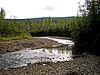 More images | |
| Dredge No. 4 National Historic Site | Lot 586, group 1052 Bonanza Creek YT | 63°56′38″N 139°20′10″W / 63.9439°N 139.336°W / 63.9439; -139.336 (Dredge No. 4 National Historic Site) | Federal (6280) |  More images | |
| Caribou Hotel | Dawson Charlie Street Carcross YT | 60°09′55″N 134°42′22″W / 60.1652°N 134.706°W / 60.1652; -134.706 (Caribou Hotel) | Yukon (9834) | 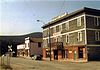 More images | |
| White Pass and Yukon Railway Station | Main Street Carcross YT | 60°09′54″N 134°42′18″W / 60.165°N 134.705°W / 60.165; -134.705 (White Pass and Yukon Railway Station) | Federal (6723) |  More images | |
| St. Paul's Anglican Church National Historic Site | Dawson City YT | 64°03′33″N 139°26′20″W / 64.0591°N 139.439°W / 64.0591; -139.439 (St. Paul's Anglican Church (Dawson City, Yukon)St. Paul's Anglican Church National Historic Site) | Federal (14122) | 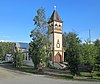 More images | |
| S.S. Keno National Historic Site | Dawson City YT | 64°03′45″N 139°26′10″W / 64.0625°N 139.436°W / 64.0625; -139.436 (S.S. Keno National Historic Site) | Federal (9308) |  More images | |
| Lowe's Mortuary | Dawson City YT | 64°03′45″N 139°25′55″W / 64.0626°N 139.432°W / 64.0626; -139.432 (Lowe’s Mortuary) | Federal (9692) |  | |
| Bank of British North America | Queen Street Dawson City YT | 64°03′44″N 139°26′02″W / 64.0623°N 139.4339°W / 64.0623; -139.4339 (Bank of British North America) | Federal (11263) | 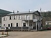 | |
| BYN Ticket Office | Dawson City YT | 64°03′49″N 139°26′02″W / 64.0636°N 139.434°W / 64.0636; -139.434 (BYN Ticket Office) | Federal (9704) |  | |
| Canadian Bank of Commerce National Historic Site of Canada | Front and Queen Streets Dawson City YT | 64°03′46″N 139°26′07″W / 64.0628°N 139.4352°W / 64.0628; -139.4352 (Canadian Bank of Commerce National Historic Site of Canada) | Federal (15524) |  | |
| KTM Building | Dawson City YT | 64°03′40″N 139°25′56″W / 64.0612°N 139.4322°W / 64.0612; -139.4322 (KTM Building) | Federal (11425) |  Upload Photo | |
| NWMP Married Quarters | Dawson City YT | 64°03′25″N 139°26′17″W / 64.057°N 139.438°W / 64.057; -139.438 (NWMP Married Quarters) | Federal (9824) | Upload Photo | |
| Mme. Tremblay’s Store (16) | Dawson City YT | 64°03′46″N 139°25′44″W / 64.0628°N 139.429°W / 64.0628; -139.429 (Mme. Tremblay’s Store (16)) | Federal (9826) |  | |
| Harrington’s Store (15) | Dawson City YT | 64°03′38″N 139°26′02″W / 64.0606°N 139.434°W / 64.0606; -139.434 (Harrington’s Store (15)) | Federal (9829) |  More images | |
| North West Mounted Police Stables | Dawson City YT | 64°03′26″N 139°26′17″W / 64.0572°N 139.438°W / 64.0572; -139.438 (North West Mounted Police Stables) | Federal (9842) | Upload Photo | |
| North West Mounted Police Jail | Dawson City YT | 64°03′25″N 139°26′13″W / 64.057°N 139.437°W / 64.057; -139.437 (North West Mounted Police Jail) | Federal (9854) | Upload Photo | |
| Northern Commercial Company Warehouse | Dawson City YT | 64°03′42″N 139°25′37″W / 64.0617°N 139.427°W / 64.0617; -139.427 (Northern Commercial Company Warehouse) | Federal (10373) | Upload Photo | |
| Root Cellar | Dawson City YT | 64°01′39″N 139°14′46″W / 64.0276°N 139.246°W / 64.0276; -139.246 (Root Cellar) | Federal (11208) | Upload Photo | |
| General Manager's House | Dawson City YT | 64°01′39″N 139°14′35″W / 64.0276°N 139.243°W / 64.0276; -139.243 (General Manager's House) | Federal (11213) | Upload Photo | |
| Tr'ochëk National Historic Site | Dawson City YT | 64°03′04″N 139°26′28″W / 64.0512°N 139.441°W / 64.0512; -139.441 (Tr'ochëk National Historic Site) | Federal (14661) |  | |
| Dawson Daily News | 123 3rd Avenue Dawson City YT | 64°03′43″N 139°25′55″W / 64.062°N 139.432°W / 64.062; -139.432 (Dawson Daily News) | Federal (11264) | 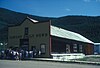 | |
| Yukon Sawmill Company Office | 1302 Front Street Dawson City YT | 64°03′57″N 139°25′48″W / 64.0657°N 139.43°W / 64.0657; -139.43 (Yukon Sawmill Company Office) | Yukon (4832) |  More images | |
| Ruby's Place | 233 Second Avenue Dawson City YT | 64°03′41″N 139°26′02″W / 64.0615°N 139.434°W / 64.0615; -139.434 (Ruby's Place) | Federal (10372) |  | |
| Third Avenue Hotel, Building 14 | 309-11 Third Avenue Dawson City YT | 64°03′45″N 139°25′52″W / 64.0625°N 139.431°W / 64.0625; -139.431 (Third Avenue Hotel, Building 14) | Federal (6227) |  | |
| Commanding Officer's Residence (10) | 508 Fifth Avenue Dawson City YT | 64°03′17″N 139°26′17″W / 64.0547°N 139.438°W / 64.0547; -139.438 (Commanding Officer's Residence (10)) | Federal (9825) | Upload Photo | |
| Dawson City Telegraph Office | 512 Seventh Avenue Dawson City YT | 64°03′21″N 139°25′59″W / 64.0558°N 139.433°W / 64.0558; -139.433 (Dawson City Telegraph Office) | Yukon (3920) |  More images | |
| Old Territorial Administration Building National Historic Site | 595 Fifth Avenue Dawson City YT | 64°03′21″N 139°26′13″W / 64.0559°N 139.437°W / 64.0559; -139.437 (Old Territorial Administration Building National Historic Site) | Federal (15784) |  | |
| St. Andrew's Manse | 601 Fourth Avenue Dawson City YT | 64°03′45″N 139°25′52″W / 64.0625°N 139.431°W / 64.0625; -139.431 (St. Andrew's Manse) | Federal (10364) | Upload Photo | |
| Auto Repair Shop, Building #7 | Bear Creek Compound Dawson City YT | 64°01′37″N 139°14′35″W / 64.027040°N 139.243150°W / 64.027040; -139.243150 (Auto Repair Shop, Building #7) | Federal (6232) | Upload Photo | |
| Carpentry Shop, Building #6 | Bear Creek Compound Dawson City YT | 64°01′36″N 139°14′36″W / 64.026790°N 139.243270°W / 64.026790; -139.243270 (Carpentry Shop, Building #6) | Federal (6235) | Upload Photo | |
| Cat Repair Shop, Building #8 | Bear Creek Compound Dawson City YT | 64°01′37″N 139°14′34″W / 64.027030°N 139.242830°W / 64.027030; -139.242830 (Cat Repair Shop, Building #8) | Federal (6242) | Upload Photo | |
| Garage and Fire Hall | Bear Creek Compound Dawson City YT | 64°01′39″N 139°14′33″W / 64.027540°N 139.2425°W / 64.027540; -139.2425 (Garage and Fire Hall) | Federal (11215) | Upload Photo | |
| Garage and Storage Building | Bear Creek Compound Dawson City YT | 64°01′39″N 139°14′32″W / 64.0276°N 139.2423°W / 64.0276; -139.2423 (Garage and Storage Building) | Federal (11227) | Upload Photo | |
| Gas House | Bear Creek Compound Dawson City YT | 64°01′35″N 139°14′33″W / 64.0263°N 139.242620°W / 64.0263; -139.242620 (Gas House) | Federal (10778) | Upload Photo | |
| Mess Hall and Bunkhouse | Bear Creek Compound Dawson City YT | 64°01′41″N 139°14′38″W / 64.027950°N 139.243750°W / 64.027950; -139.243750 (Mess Hall and Bunkhouse) | Federal (11210) | Upload Photo | |
| Staff House | Bear Creek Compound Dawson City YT | 64°01′37″N 139°14′31″W / 64.0270°N 139.2420°W / 64.0270; -139.2420 (Staff House) | Federal (11112) | Upload Photo | |
| Tin Shop | Bear Creek Compound Dawson City YT | 64°01′36″N 139°14′35″W / 64.026730°N 139.243040°W / 64.026730; -139.243040 (Tin Shop) | Federal (9882) | Upload Photo | |
| Troberg Residence, Building #67 | Bear Creek Compound Dawson City YT | 64°01′48″N 139°14′16″W / 64.029890°N 139.237770°W / 64.029890; -139.237770 (Troberg Residence, Building #67) | Federal (9890) | Upload Photo | |
| V.I.P. Guest House | Bear Creek Compound Dawson City YT | 64°01′38″N 139°14′30″W / 64.027320°N 139.241620°W / 64.027320; -139.241620 (V.I.P. Guest House) | Federal (9922) | Upload Photo | |
| Warehouse No. 1, Building #27 | Bear Creek Compound Dawson City YT | 64°01′38″N 139°14′40″W / 64.027120°N 139.244450°W / 64.027120; -139.244450 (Warehouse No. 1, Building #27) | Federal (9923) | Upload Photo | |
| Warehouse No. 2 | Bear Creek Compound Dawson City YT | 64°00′N 139°14′W / 64.0°N 139.24°W / 64.0; -139.24 (Warehouse No. 2) | Federal (10819) | Upload Photo | |
| Warehouse No. 3, Building #35 | Bear Creek Compound Dawson City YT | 64°01′38″N 139°14′45″W / 64.027170°N 139.245870°W / 64.027170; -139.245870 (Warehouse No. 3, Building #35) | Federal (9924) | Upload Photo | |
| Engineering Office (Building 19) | Bear Creek Compound Dawson City YT | 64°01′40″N 139°14′37″W / 64.027680°N 139.243530°W / 64.027680; -139.243530 (Engineering Office (Building 19)) | Federal (9925) | Upload Photo | |
| Engineering Office (Building 28) | Bear Creek Compound Dawson City YT | 64°01′38″N 139°14′41″W / 64.027240°N 139.244700°W / 64.027240; -139.244700 (Engineering Office (Building 28)) | Federal (9926) | Upload Photo | |
| Gold Room. Building #29 | Bear Creek Compound Dawson City YT | 64°01′39″N 139°14′44″W / 64.027470°N 139.24552°W / 64.027470; -139.24552 (Gold Room. Building #29) | Federal (11214) | Upload Photo | |
| Machine Shop, Building #1 & #2 | Bear Creek Compound Dawson City YT | 64°01′37″N 139°14′38″W / 64.026860°N 139.24383°W / 64.026860; -139.24383 (Machine Shop, Building #1 & #2) | Federal (11226) | Upload Photo | |
| St. Andrew's Presbyterian Church | Church / Fourth Street Dawson City YT | 64°03′45″N 139°25′52″W / 64.0625°N 139.431°W / 64.0625; -139.431 (St. Andrew's Presbyterian Church) | Federal (10366) |  More images | |
| Former Territorial Court House National Historic Site | Corner of Front and Turner Streets Dawson City YT | 64°03′23″N 139°26′28″W / 64.0563°N 139.441°W / 64.0563; -139.441 (Former Territorial Court House National Historic Site) | Federal (12743, (16081) |  | |
| Robert Service Cabin | Eighth / Hansen Street Dawson City YT | 64°03′45″N 139°25′52″W / 64.0625°N 139.431°W / 64.0625; -139.431 (Robert W. Service#Dawson City cabinRobert Service Cabin) | Federal (10368) |  | |
| Black Residence, No. 9 | Fifth Avenue and Turner Street Dawson City YT | 64°03′15″N 139°26′17″W / 64.0542°N 139.438°W / 64.0542; -139.438 (Black Residence, No. 9) | Federal (6226) | Upload Photo | |
| Yukon Hotel National Historic Site | First Avenue Dawson City YT | 64°03′33″N 139°26′17″W / 64.0591°N 139.438°W / 64.0591; -139.438 (Yukon Hotel National Historic Site) | Federal (9163) | 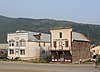 More images | |
| Commissioner's Residence | Front Street Dawson City YT | 64°03′24″N 139°26′28″W / 64.0567°N 139.441°W / 64.0567; -139.441 (Commissioner's Residence) | Federal (15641) |  | |
| Post Office | King Street and Third Avenue Dawson City YT | 64°03′47″N 139°25′52″W / 64.063°N 139.431°W / 64.063; -139.431 (Post Office) | Federal (11629) |  | |
| Winaut's Store | Second Avenue Dawson City YT | 64°03′23″N 139°26′10″W / 64.0565°N 139.436°W / 64.0565; -139.436 (Winaut's Store) | Federal (6241) | Upload Photo | |
| Dawson Historical Complex National Historic Site | Third Avenue Dawson City YT | 64°03′48″N 139°25′52″W / 64.0634°N 139.431°W / 64.0634; -139.431 (Dawson Historical Complex National Historic Site) | Federal (6253) |  | |
| Mabel Mcintyre House | 12 Centre Street Mayo YT | 63°35′36″N 135°53′46″W / 63.5932°N 135.896°W / 63.5932; -135.896 (Mabel Mcintyre House) | Yukon (1282) | Upload Photo | |
| Mayo Legion Hall | 310 First Ave Mayo YT | 63°35′28″N 135°53′42″W / 63.5912°N 135.895°W / 63.5912; -135.895 (Mayo Legion Hall) | Yukon (6585) | Upload Photo | |
| SS Klondike National Historic Site | Whitehorse YT | 60°42′48″N 135°02′53″W / 60.7133°N 135.048°W / 60.7133; -135.048 (SS Klondike National Historic Site) | Federal (9348) | 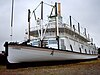 More images | |
| Smith House | 3128 Third Ave. Whitehorse LePage Park Whitehorse YT | 60°43′14″N 135°03′19″W / 60.7206°N 135.0553°W / 60.7206; -135.0553 (Smith House) | Whitehorse municipality (8903) |  | |
| Train Crew's House 1 | 1091 First Ave Whitehorse YT | 60°43′07″N 135°02′56″W / 60.7187°N 135.049°W / 60.7187; -135.049 (Train Crew's House 1) | Whitehorse municipality (15133) |  | |
| Train Crew's House 2 | 1093 First Avenue Whitehorse YT | 60°43′08″N 135°02′56″W / 60.7188°N 135.049°W / 60.7188; -135.049 (Train Crew's House 2) | Whitehorse municipality (15134) | Upload Photo | |
| Old Firehall | 1105 First Avenue Whitehorse YT | 60°43′10″N 135°03′00″W / 60.7195°N 135.05°W / 60.7195; -135.05 (Old Firehall) | Whitehorse municipality (14867) |  | |
| White Pass and Yukon Route Railway Depot | 1109 First Ave Whitehorse YT | 60°43′12″N 135°03′00″W / 60.7201°N 135.05°W / 60.7201; -135.05 (White Pass and Yukon Route Railway Depot) | Whitehorse municipality (4471) |  More images | |
| Building 200 | 200 Range Road Whitehorse YT | 60°44′17″N 135°05′17″W / 60.7381°N 135.088°W / 60.7381; -135.088 (Building 200) | Federal (10792) | Upload Photo | |
| Log Skyscrapers | 208 Lambert Street Whitehorse YT | 60°43′04″N 135°03′07″W / 60.7179°N 135.052°W / 60.7179; -135.052 (Log Skyscrapers) | Whitehorse municipality (1903) |  | |
| T.C. Richards Building | 302 Steele Street Whitehorse YT | 60°43′12″N 135°03′18″W / 60.72°N 135.055°W / 60.72; -135.055 (T.C. Richards Building) | Whitehorse municipality (4574) | Upload Photo | |
| Donnenworth House | 3126 Third Avenue Whitehorse YT | 60°43′13″N 135°03′18″W / 60.7204°N 135.055°W / 60.7204; -135.055 (Donnenworth House) | Whitehorse municipality (6592) |  | |
| The Taylor House | 412 Main Street Whitehorse YT | 60°43′08″N 135°03′29″W / 60.7188°N 135.058°W / 60.7188; -135.058 (The Taylor House) | Yukon (4833) | Upload Photo | |
| Pioneer Hotel 2 | Shipyards Park Whitehorse YT | 60°43′42″N 135°03′18″W / 60.7284°N 135.055°W / 60.7284; -135.055 (Pioneer Hotel 2) | Whitehorse municipality (8904) |  | |
| T'äw Tà'är National Historic Site of Canada | 30 miles east of Lake Laberge on the Teslin River Teslin River, Yukon YT | 61°14′37″N 134°37′00″W / 61.2435°N 134.6168°W / 61.2435; -134.6168 (T'aw Taaar National Historic Site of Canada) | Federal (19568) | Upload Photo |
See also
Wikimedia Commons has media related to Cultural heritage monuments in Yukon.
- v
- t
- e
- CRHP
- List of historic places
- Canadian Bank of Commerce
- Dawson Historical Complex
- Discovery Claim (Claim 37903)
- Dredge No. 4
- Former Territorial Court House
- Old Territorial Administration Building
- SS Keno
- SS Klondike
- St. Paul's Anglican Church
- T'äw Tà'är
- Tr'ochëk
- Yukon Hotel
- Agay Mene (proposed)
- Asi Keyi (proposed)
- Coal River Springs
- Dàadzàii Vàn (proposed)
- Kusawa (proposed)
- Ni'iinlii'njik (Fishing Branch)
- Qikiqtaruk
- Tombstone
- Nisutlin River Delta
 Category
 Commons


