Matsudai, Niigata
Former municipality in Hokuriku, Japan
Matsudai  Flag  Emblem | |
|---|---|
| Country | Japan |
| Region | Hokuriku |
| Prefecture | Niigata Prefecture |
| District | Higashikubiki District |
| Merged | April 1, 2005 (now part of Tōkamachi) |
| Area | |
| • Total | 90.47 km2 (34.93 sq mi) |
| Population (2003) | |
| • Total | 4,016 |
| Time zone | UTC+09:00 (JST) |

Matsudai (松代町, Matsudai-machi) was a town located in Higashikubiki District, Niigata Prefecture, Japan.

As of 2003, the town had an estimated population of 4,016 and a density of 44.39 persons per km2. The total area was 90.47 km2.
On April 1, 2005, Matsudai, along with the town of Matsunoyama (also from Higashikubiki District), the town of Kawanishi, and the village of Nakasato, both from Nakauonuma District, was merged into the expanded city of Tōkamachi.[1][2]
Transportation
Railway
![]() Hokuetsu Express Hokuhoku Line
Hokuetsu Express Hokuhoku Line
Highway


Local attractions
Matsudai is one of the sites of the Echigo-Tsumari Art Triennial, first held in 2000. The Matsudai Snow-Land Agrarian Culture Centre (aka Matsudai Nobutai) was built in 2003 by architects MVRDV as part of the Triennial and is the focal point for local contemporary art activities. The centre includes an event space, classroom, gallery, art shop, and restaurant.
-
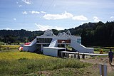 Matsudai Nohbutai
 -
 Hoshitoge Rice Terrace
 -
 Gamo Rice Terrace


References
- ^ 住民基本台帳人口移動報告年報 (in Japanese). 総務庁統計局. 2005. p. 139.
Tokamachi-shi, Kawanishi-machi, Nakasato-mura, Matsudai-machi and Matsunoyama-machi were incorporated into a newly established Tokamachi-shi as of April 1, 2005.
- ^ "十日町市の沿革|十日町市". 十日町市 (in Japanese). Retrieved 2024-02-04.
十日町市は、平成17年4月1日に旧十日町市、川西町、中里村、松代町及び松之山町の5市町村が新設合併して誕生しました。
- v
- t
- e
Dissolved municipalities of  Niigata Prefecture
 Niigata Prefecture
| 2001 | |
|---|---|
| 2005 |
| 2008 |
|---|
| 2005 |
|---|
| 2003 | |
|---|---|
| 2005 |
| 2004 |
|---|
| 2005 |
|---|
| 2005 |
|---|
| 2006 |
|---|
| 2005 |
|---|
| 2005 | |
|---|---|
| 2006 | |
| 2010 |
| 2005 |
|---|
| 2005 |
|
|---|
| 2004 |
|---|
| 2004 | |
|---|---|
| 2005 |
| 2005 |
|---|
| 2005 |
|
|---|
| 2005 |
|---|
| 2004 |
|---|
Authority control databases | |
|---|---|
| International |
|
| National |
|
 | This Niigata Prefecture location article is a stub. You can help Wikipedia by expanding it. |
- v
- t
- e


