Mount Loura
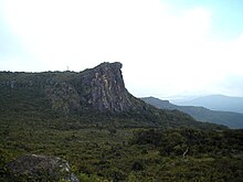
Mount Loura (Fello Loura in the Pular language) is the northernmost point and highest peak at 1,573 metres (5,161 ft) in the Fouta Djallon in northern Guinea.[1] It is 7 km from the prefecture of Mali-ville. It is part of a complex of mountains called the Massif de Tamgue, which rises to steep cliffs on three sides, and provides views into Senegal and Mali.
References
- ^ O'Toole, Thomas; Baker, Janice E. (2005-03-16). Historical Dictionary of Guinea. Scarecrow Press. p. 145. ISBN 9780810865457. Retrieved 11 December 2014.
12°06′44″N 12°15′49″W / 12.1123°N 12.2635°W / 12.1123; -12.2635


