Nan'ao, Yilan
Mountain indigenous township

Seal
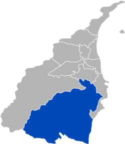
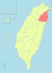
Nan'ao Township in Yilan County
(September 2023)

Nan'ao Township (Chinese: 南澳鄕; pinyin: Nán'ào Xiāng) is a mountain indigenous township in the southern part of Yilan County, Taiwan. It is the largest township in the county.
History
The township was formerly the "Aboriginal Area" of Suō District, Taihoku Prefecture during Japanese rule. It was the site of the Sayun incident made famous through the movie Sayon's Bell.
Geography

The population consists mainly of the indigenous Atayal people. Many residents of Aohua Village still speak the Japanese language in daily life.[1]
Nan'ao Township contains part of the mountainous terrain of the Central Mountain Range.
- Area: 740.65 km2
- Population: 6,110 people in 2,092 households (September 2023)
Administrative divisions
Nanao is divided into seven villages (from north to south):
- Dongyue
- Nan'ao
- Biho
- Jinyue
- Wuta
- Jinyang
- Aohua
Tourist attractions
- Cueifong Lake
Transportation

Nan'ao is served by the North-Link Line of Taiwan Railway Administration at three stations: Dong'ao Station, Hanben Station, and Wuta Station.
Taiwan Highway 9 passes through Nan'ao. Between Su'ao and Hualien City, to the south, this road is known as the Suhua Highway (蘇花公路), and it features some of the most dramatic oceanside scenery in Taiwan.
Notable natives
- Laha Mebow, writer, producer and director
References
- ^ "'Japanized' ethnic minority in Taiwan struggling to restore their own language". Japan Times. 20 February 2018. Retrieved 18 March 2018.
External links
Wikimedia Commons has media related to Nan'ao Township, Yilan County.
Wikivoyage has a travel guide for Nanao.
- Official website
 (in Chinese)
- v
- t
- e
Cities and townships of Yilan County
- Datong
- Nan'ao
Taiwanese Indigenous Areas | ||||||||||||||||||||||||||
|---|---|---|---|---|---|---|---|---|---|---|---|---|---|---|---|---|---|---|---|---|---|---|---|---|---|---|
| Highland indigenous Townships and Districts |
| 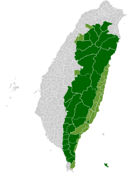 | ||||||||||||||||||||||||
| Plains indigenous Townships and County-Administered Cities |
| |||||||||||||||||||||||||
Note: On the map, "Mountain Indigenous Areas" are in dark green and "Plains Indigenous Areas" are in light green. | ||||||||||||||||||||||||||
| Authority control databases: Geographic |
|
|---|
24°28′N 121°48′E / 24.467°N 121.800°E / 24.467; 121.800


