National Register of Historic Places listings in Halifax County, Virginia

This is a list of the National Register of Historic Places listings in Halifax County, Virginia.
This is intended to be a complete list of the properties and districts on the National Register of Historic Places in Halifax County, Virginia, United States. The locations of National Register properties and districts for which the latitude and longitude coordinates are included below, may be seen in an online map.[1]
There are 39 properties and districts listed on the National Register in the county, including 1 National Historic Landmark.
This National Park Service list is complete through NPS recent listings posted June 14, 2024.[2]
Map all coordinates using OpenStreetMap
Download coordinates as:
- KML
- GPX (all coordinates)
- GPX (primary coordinates)
- GPX (secondary coordinates)
Current listings
| [3] | Name on the Register[4] | Image | Date listed[5] | Location | City or town | Description |
|---|---|---|---|---|---|---|
| 1 | Berry Hill |  | November 25, 1969 (#69000246) | South of the junction of River and Berry Hill Rds. 36°41′55″N 78°56′38″W / 36.698611°N 78.943889°W / 36.698611; -78.943889 (Berry Hill) | South Boston | |
| 2 | Black Walnut |  | October 29, 1991 (#91001597) | Black Walnut Rd., 850 feet (260 m) south of its junction with Green Valley Rd. 36°51′49″N 78°43′20″W / 36.863611°N 78.722222°W / 36.863611; -78.722222 (Black Walnut) | Clover | |
| 3 | Bloomsburg (Watkins House) |  | August 28, 2017 (#100001509) | 9000 U.S. Route 58 36°37′59″N 79°01′16″W / 36.633056°N 79.021111°W / 36.633056; -79.021111 (Bloomsburg (Watkins House)) | South Boston | |
| 4 | Brandon Plantation |  | April 26, 1996 (#96000495) | Coleman Dr., 500 feet (150 m) west of its junction with Henderson Rd. 36°34′38″N 79°07′07″W / 36.577222°N 79.118611°W / 36.577222; -79.118611 (Brandon Plantation) | Alton | |
| 5 | Brandon-on-the-Dan |  | August 28, 2017 (#100001510) | 1072 State Route 119 36°34′51″N 79°08′28″W / 36.580833°N 79.141111°W / 36.580833; -79.141111 (Brandon-on-the-Dan) | Alton | |
| 6 | Brooklyn Store and Post Office |  | January 22, 1996 (#95001557) | Northern side of Brooklyn Rd., 0.1 miles (0.16 km) west of its junction with Jeremy Creek Rd. 36°40′38″N 79°09′05″W / 36.677222°N 79.151250°W / 36.677222; -79.151250 (Brooklyn Store and Post Office) | Brooklyn | |
| 7 | Brooklyn Tobacco Factory |  | January 22, 1996 (#95001559) | Northern side of River Rd., 0.25 miles (0.40 km) east of its junction with Jeremy Creek Rd. 36°40′45″N 79°08′42″W / 36.679167°N 79.145000°W / 36.679167; -79.145000 (Brooklyn Tobacco Factory) | Brooklyn | |
| 8 | Buckshoal Farm | 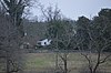 | September 16, 1987 (#87001473) | Hudson Rd. 36°38′34″N 78°46′14″W / 36.642639°N 78.770556°W / 36.642639; -78.770556 (Buckshoal Farm) | Omega | |
| 9 | Carlbrook | 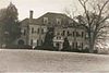 | May 26, 2000 (#00000556) | Carlbrook Rd. at its junction with Hummingbird Ln. 36°43′42″N 79°08′10″W / 36.728333°N 79.136111°W / 36.728333; -79.136111 (Carlbrook) | Halifax | |
| 10 | Carter's Tavern |  | October 11, 1974 (#74002120) | Southeast of Ingram 36°40′31″N 79°08′03″W / 36.675278°N 79.134167°W / 36.675278; -79.134167 (Carter's Tavern) | Paces | |
| 11 | Cedar Grove |  | August 28, 2017 (#100001511) | 1083 Blanes Mill Ln. 36°36′37″N 78°59′31″W / 36.610278°N 78.991944°W / 36.610278; -78.991944 (Cedar Grove) | Alton | |
| 12 | Clarkton | Upload image | May 4, 2023 (#100008948) | 1216 Hogwallow Rd. 36°59′44″N 78°55′23″W / 36.9956°N 78.9230°W / 36.9956; -78.9230 (Clarkton) | Nathalie vicinity | |
| 13 | Clarkton Bridge |  | January 26, 2007 (#06000747) | Clarkton Bridge Rd. over the Staunton River 36°58′40″N 78°53′49″W / 36.977778°N 78.896944°W / 36.977778; -78.896944 (Clarkton Bridge) | Nathalie | Extends into Charlotte County |
| 14 | Collins Ferry Historic District |  | November 28, 2012 (#12000986) | McKeever Trail and Bull Creek Rd. 37°02′19″N 79°02′23″W / 37.038611°N 79.039722°W / 37.038611; -79.039722 (Collins Ferry Historic District) | Nathalie | |
| 15 | The Cove | 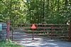 | May 11, 2006 (#06000407) | 5059 Cove Rd. 36°58′57″N 78°44′40″W / 36.982500°N 78.744444°W / 36.982500; -78.744444 (The Cove) | Harrisburg | |
| 16 | DeJarnette's Tavern |  | May 2, 2007 (#07000398) | 4080 Stagecoach Rd. 37°00′48″N 79°00′21″W / 37.013333°N 79.005833°W / 37.013333; -79.005833 (DeJarnette's Tavern) | Nathalie | Late 18th century stagecoach station and tavern. |
| 17 | Dewberry Hill |  | February 13, 2018 (#100002133) | 2181 Wilkins Rd. 36°35′48″N 79°02′52″W / 36.596667°N 79.047778°W / 36.596667; -79.047778 (Dewberry Hill) | Alton | |
| 18 | E. L. Evans House |  | May 8, 2008 (#08000388) | 1204 Washington Ave. 36°42′16″N 78°54′02″W / 36.704444°N 78.900556°W / 36.704444; -78.900556 (E. L. Evans House) | South Boston | |
| 19 | Fourqurean House |  | May 6, 1980 (#80004192) | 2.4 miles (3.9 km) southwest of South Boston 36°39′20″N 78°56′28″W / 36.655556°N 78.941111°W / 36.655556; -78.941111 (Fourqurean House) | South Boston | |
| 20 | Glennmary | 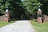 | February 1, 1979 (#79003043) | Southwest of South Boston on U.S. Route 58 36°40′49″N 78°55′58″W / 36.680139°N 78.932778°W / 36.680139; -78.932778 (Glennmary) | South Boston | |
| 21 | Glenwood |  | August 28, 2017 (#100001512) | 7040 U.S. Route 58 36°39′08″N 78°59′54″W / 36.652361°N 78.998333°W / 36.652361; -78.998333 (Glenwood) | South Boston | |
| 22 | Halifax County Courthouse |  | September 16, 1982 (#82004563) | Junction of U.S. Routes 360 and 501 36°45′56″N 78°55′46″W / 36.7656°N 78.9294°W / 36.7656; -78.9294 (Halifax County Courthouse) | Halifax | |
| 23 | Indian Jim's Cave | Upload image | August 26, 1982 (#82004562) | Address Restricted | Brookneal | |
| 24 | Mountain Road Historic District |  | October 6, 1983 (#83004245) | Roughly Mountain Rd. from Mimosa Dr. to Academy St.; also Mountain Rd., Academy St., and Poplar Ln. 36°46′03″N 78°56′03″W / 36.7675°N 78.9342°W / 36.7675; -78.9342 (Mountain Road Historic District) | Halifax | Second set of boundaries represents a boundary increase of August 24, 2015 |
| 25 | Oak Cliff | Upload image | November 18, 2020 (#100005804) | 10000 Huell Matthews Hwy. (US 501) 36°34′33″N 78°53′40″W / 36.5757°N 78.8945°W / 36.5757; -78.8945 (Oak Cliff) | Alton vicinity | |
| 26 | Old Providence Presbyterian Church |  | July 7, 1988 (#88001013) | Cole Ferry Rd. 36°56′16″N 78°49′10″W / 36.9378°N 78.8194°W / 36.9378; -78.8194 (Old Providence Presbyterian Church) | Providence | |
| 27 | Pleasant Grove | 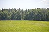 | August 5, 1999 (#99000966) | Deer Run Rd. 36°43′30″N 79°02′55″W / 36.7250°N 79.0486°W / 36.7250; -79.0486 (Pleasant Grove) | Halifax | |
| 28 | Redfield |  | September 20, 1978 (#78003020) | 3 miles (4.8 km) southeast of Oak Level on Oak Level Rd. 36°42′02″N 79°04′39″W / 36.7006°N 79.0775°W / 36.7006; -79.0775 (Redfield) | Oak Level | |
| 29 | Reedy Creek Site |  | April 26, 1978 (#78003187) | Northern side of the Dan River at the Reedy Creek confluence[6]: 154 36°41′40″N 78°52′39″W / 36.6944°N 78.8775°W / 36.6944; -78.8775 (Reedy Creek Site) | South Boston | |
| 30 | Riverside |  | February 13, 2018 (#100002134) | 11161 River Rd. 36°39′42″N 79°04′26″W / 36.6617°N 79.0739°W / 36.6617; -79.0739 (Riverside) | Sutherlin | |
| 31 | Seaton |  | May 19, 1980 (#80004193) | North of South Boston on U.S. Route 501 36°44′41″N 78°55′22″W / 36.7447°N 78.9228°W / 36.7447; -78.9228 (Seaton) | South Boston | |
| 32 | South Boston Historic District |  | September 26, 1986 (#86002471) | Along Railroad Ave., Ferry, Factory, and Main Sts., Wilborn Ave., N. Main St., Washington and Peach Aves., and Jeffress; also neighborhoods of Marshall Ave., New Brick Warehouse, Mizpah Church, N. Main St. 36°41′51″N 78°54′05″W / 36.6975°N 78.9014°W / 36.6975; -78.9014 (South Boston Historic District) | South Boston | Second set of boundaries represents a boundary increase of June 11, 2009 |
| 33 | Staunton River Bridge Fortification |  | November 19, 2014 (#04000577) | Fort Hill Trail at Staunton River Battlefield State Park[7] 36°52′54″N 78°42′06″W / 36.8817°N 78.7017°W / 36.8817; -78.7017 (Staunton River Bridge Fortification) | Randolph | |
| 34 | Staunton River State Park Historic District | 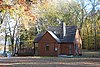 | May 4, 2007 (#07000402) | 1170 Staunton Trail 36°41′58″N 78°40′04″W / 36.6994°N 78.6678°W / 36.6994; -78.6678 (Staunton River State Park Historic District) | Scottsburg | |
| 35 | Tarover |  | September 20, 1978 (#78003021) | West of South Boston on River Rd. 36°42′03″N 78°57′54″W / 36.7007°N 78.9650°W / 36.7007; -78.9650 (Tarover) | South Boston | |
| 36 | Dr. Richard Thornton House |  | November 28, 2012 (#12000987) | Golden Leaf and Tobacco Rds. 36°58′38″N 79°01′58″W / 36.9772°N 79.0328°W / 36.9772; -79.0328 (Dr. Richard Thornton House) | Nathalie | |
| 37 | Town of Halifax Court House Historic District |  | January 28, 2011 (#10001187) | Main St., Cemetery St., Prizery St., Edmunds Boulevard, Mary Bethune St., Cowford Rd., Maple Ave., Church St., and Cary St. 36°45′58″N 78°55′43″W / 36.7661°N 78.9286°W / 36.7661; -78.9286 (Town of Halifax Court House Historic District) | Halifax | |
| 38 | Vaughan House | Upload image | January 24, 2019 (#100003348) | 1014 Washington Ave. 36°42′12″N 78°54′02″W / 36.7033°N 78.9006°W / 36.7033; -78.9006 (Vaughan House) | South Boston | |
| 39 | Walters-Moshier House | 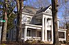 | February 14, 2018 (#100002135) | 1421 N. Main St. 36°42′30″N 78°53′56″W / 36.7082°N 78.8989°W / 36.7082; -78.8989 (Walters-Moshier House) | South Boston |
See also
Wikimedia Commons has media related to National Register of Historic Places in Halifax County, Virginia.
- List of National Historic Landmarks in Virginia
- National Register of Historic Places listings in Virginia
References
- ^ The latitude and longitude information provided in this table was derived originally from the National Register Information System, which has been found to be fairly accurate for about 99% of listings. Some locations in this table may have been corrected to current GPS standards.
- ^ National Park Service, United States Department of the Interior, "National Register of Historic Places: Weekly List Actions", retrieved June 14, 2024.
- ^ Numbers represent an alphabetical ordering by significant words. Various colorings, defined here, differentiate National Historic Landmarks and historic districts from other NRHP buildings, structures, sites or objects.
- ^ "National Register Information System". National Register of Historic Places. National Park Service. April 24, 2008.
- ^ The eight-digit number below each date is the number assigned to each location in the National Register Information System database, which can be viewed by clicking the number.
- ^ Coleman, G.N. "The Reedy Creek Site, 44HA22, South Boston, Virginia". Quarterly Bulletin of the Archeological Society of Virginia 37.4 (1982): 150-203
- ^ Trail Guide: Staunton River Battlefield State Park. Virginia Department of Conservation and Recreation, n.d. Accessed 2017-05-30.
- v
- t
- e
by county
- Accomack
- Albemarle
- Alleghany
- Amelia
- Amherst
- Appomattox
- Arlington
- Augusta
- Bath
- Bedford
- Bland
- Botetourt
- Brunswick
- Buchanan
- Buckingham
- Campbell
- Caroline
- Carroll
- Charles City
- Charlotte
- Chesterfield
- Clarke
- Craig
- Culpeper
- Cumberland
- Dickenson
- Dinwiddie
- Essex
- Fairfax
- Fauquier
- Floyd
- Fluvanna
- Franklin
- Frederick
- Giles
- Gloucester
- Goochland
- Grayson
- Greene
- Greensville
- Halifax
- Hanover
- Henrico
- Henry
- Highland
- Isle Of Wight
- James City
- King and Queen
- King George
- King William
- Lancaster
- Lee
- Loudoun
- Louisa
- Lunenburg
- Madison
- Mathews
- Mecklenburg
- Middlesex
- Montgomery
- Nelson
- New Kent
- Northampton
- Northumberland
- Nottoway
- Orange
- Page
- Patrick
- Pittsylvania
- Powhatan
- Prince Edward
- Prince George
- Prince William
- Pulaski
- Rappahannock
- Richmond
- Roanoke
- Rockbridge
- Rockingham
- Russell
- Scott
- Shenandoah
- Smyth
- Southampton
- Spotsylvania
- Stafford
- Surry
- Sussex
- Tazewell
- Warren
- Washington
- Westmoreland
- Wise
- Wythe
- York

by city
- Alexandria
- Bristol
- Buena Vista
- Charlottesville
- Chesapeake
- Colonial Heights
- Covington
- Danville
- Emporia
- Fairfax
- Falls Church
- Franklin
- Fredericksburg
- Galax
- Hampton
- Harrisonburg
- Hopewell
- Lexington
- Lynchburg
- Manassas
- Manassas Park
- Martinsville
- Newport News
- Norfolk
- Norton
- Petersburg
- Poquoson (no listings)
- Portsmouth
- Radford
- Richmond
- Roanoke
- Salem
- Staunton
- Suffolk
- Virginia Beach
- Waynesboro
- Williamsburg
- Winchester
Municipalities and communities of Halifax County, Virginia, United States | ||
|---|---|---|
County seat: Halifax | ||
| Towns |  | |
| CDPs | ||
| Unincorporated communities |
| |
| Footnotes | ‡This populated place also has portions in an adjacent county or counties | |
| ||


