National Register of Historic Places listings in Modoc County, California

This is a list of the National Register of Historic Places listings in Modoc County, California.
This is intended to be a complete list of the properties and districts on the National Register of Historic Places in Modoc County, California, United States. Latitude and longitude coordinates are provided for many National Register properties and districts; these locations may be seen together in a Google map.[1]
There are 18 properties and districts listed on the National Register in the county, including 1 National Historic Landmark.
This National Park Service list is complete through NPS recent listings posted May 10, 2024.[2]
Map all coordinates using OpenStreetMap
Download coordinates as:
- KML
- GPX (all coordinates)
- GPX (primary coordinates)
- GPX (secondary coordinates)
Current listings
| [3] | Name on the Register[4] | Image | Date listed[5] | Location | City or town | Description |
|---|---|---|---|---|---|---|
| 1 | Adin Supply Company |  | February 7, 1997 (#97000028) | W side of Main St. between Center and McDowell Sts. 41°11′50″N 120°56′40″W / 41.197118°N 120.944349°W / 41.197118; -120.944349 (Adin Supply Company) | Adin | |
| 2 | Anklin Village Archeological Site | Upload image | June 3, 1976 (#76000500) | Address Restricted | Canby | |
| 3 | Black Cow Spring | Upload image | July 9, 1974 (#74000341) | Address Restricted | Canby | |
| 4 | Core Site | Upload image | April 8, 1974 (#74000531) | Address Restricted | Canby | |
| 5 | Cuppy Cave | Upload image | July 12, 1974 (#74000342) | Address Restricted | Canby | |
| 6 | Fern Cave Archeological Site | 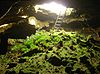 | May 29, 1975 (#75000224) | Address Restricted | Tulelake | |
| 7 | Jess Valley Schoolhouse | 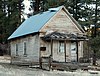 | May 20, 1999 (#99000582) | Cty. Rd. 64 41°15′59″N 120°18′39″W / 41.266452°N 120.310936°W / 41.266452; -120.310936 (Jess Valley Schoolhouse) | Likely | |
| 8 | Lava Beds National Monument Archeological District |  | March 21, 1991 (#75002182) | Address Restricted | Tulelake | |
| 9 | Mildred Ann Archeological Site | Upload image | June 3, 1976 (#76000501) | Address Restricted | Canby | |
| 10 | NCO Railway Depot |  | February 28, 1985 (#85000357) | East and 3rd Sts. 41°29′12″N 120°32′23″W / 41.486726°N 120.539791°W / 41.486726; -120.539791 (NCO Railway Depot) | Alturas | |
| 11 | Nelson Springs | Upload image | November 21, 2002 (#02001393) | Address Restricted | Likely | |
| 12 | Nevada-California-Oregon Railway Co. General Office Building |  | September 6, 1974 (#74000529) | 619 N. Main St. 41°29′23″N 120°32′35″W / 41.489632°N 120.543015°W / 41.489632; -120.543015 (Nevada-California-Oregon Railway Co. General Office Building) | Alturas | |
| 13 | Petroglyph Point Archeological Site |  | May 29, 1975 (#75000178) | Address Restricted | Tulelake | |
| 14 | Sacred Heart Catholic Church |  | June 30, 1983 (#83001209) | 507 E. 4th St. 41°29′14″N 120°32′13″W / 41.487241°N 120.536883°W / 41.487241; -120.536883 (Sacred Heart Catholic Church) | Alturas | |
| 15 | Seven Mile Flat Site | Upload image | December 24, 1974 (#74000340) | Address Restricted | Devil's Garden Ranger District | |
| 16 | Skull Ridge | Upload image | July 9, 1974 (#74000287) | Address Restricted | Canby | |
| 17 | Skull Spring | Upload image | July 9, 1974 (#74000288) | Address Restricted | Canby | |
| 18 | Tule Lake Segregation Center |  | February 17, 2006 (#06000210) | NE side CA 139 41°53′07″N 121°22′29″W / 41.885347°N 121.374833°W / 41.885347; -121.374833 (Tule Lake Segregation Center) | Newell |
See also
Wikimedia Commons has media related to National Register of Historic Places in Modoc County, California.
- List of National Historic Landmarks in California
- National Register of Historic Places listings in California
- California Historical Landmarks in Modoc County, California
References
- ^ The latitude and longitude information provided in this table was derived originally from the National Register Information System, which has been found to be fairly accurate for about 99% of listings. Some locations in this table may have been corrected to current GPS standards.
- ^ National Park Service, United States Department of the Interior, "National Register of Historic Places: Weekly List Actions", retrieved May 10, 2024.
- ^ Numbers represent an alphabetical ordering by significant words. Various colorings, defined here, differentiate National Historic Landmarks and historic districts from other NRHP buildings, structures, sites or objects.
- ^ "National Register Information System". National Register of Historic Places. National Park Service. July 9, 2010.
- ^ The eight-digit number below each date is the number assigned to each location in the National Register Information System database, which can be viewed by clicking the number.
- v
- t
- e
- List of U.S. National Historic Landmarks by state:
- Alabama
- Alaska
- Arizona
- Arkansas
- California
- Colorado
- Connecticut
- Delaware
- Florida
- Georgia
- Hawaii
- Idaho
- Illinois
- Indiana
- Iowa
- Kansas
- Kentucky
- Louisiana
- Maine
- Maryland
- Massachusetts
- Michigan
- Minnesota
- Mississippi
- Missouri
- Montana
- Nebraska
- Nevada
- New Hampshire
- New Jersey
- New Mexico
- New York
- North Carolina
- North Dakota
- Ohio
- Oklahoma
- Oregon
- Pennsylvania
- Rhode Island
- South Carolina
- South Dakota
- Tennessee
- Texas
- Utah
- Vermont
- Virginia
- Washington
- West Virginia
- Wisconsin
- Wyoming
 National Register of Historic Places portal
 Category


