National Register of Historic Places listings in Republic County, Kansas

This is a list of the National Register of Historic Places listings in Republic County, Kansas.
This is intended to be a complete list of the properties and districts on the National Register of Historic Places in Republic County, Kansas, United States. The locations of National Register properties and districts for which the latitude and longitude coordinates are included below, may be seen in a map.[1]
There are 13 properties and districts listed on the National Register in the county.
This National Park Service list is complete through NPS recent listings posted June 7, 2024.[2]
Map all coordinates using OpenStreetMap
Download coordinates as:
- KML
- GPX (all coordinates)
- GPX (primary coordinates)
- GPX (secondary coordinates)
Current listings
| [3] | Name on the Register[4] | Image | Date listed[5] | Location | City or town | Description |
|---|---|---|---|---|---|---|
| 1 | Belleville High School |  | June 25, 2013 (#13000434) | 915 W.18th Street 39°49′28″N 97°38′02″W / 39.82433°N 97.63398°W / 39.82433; -97.63398 (Belleville High School) | Belleville | |
| 2 | Cossaart Barn |  | December 30, 2009 (#09001166) | 3040 Birch Rd. 39°59′22″N 97°22′47″W / 39.989443°N 97.379850°W / 39.989443; -97.379850 (Cossaart Barn) | Narka | |
| 3 | County Line Bowstring |  | January 4, 1990 (#89002192) | Over West Creek, northwest of Hollis 39°39′12″N 97°34′21″W / 39.653333°N 97.5725°W / 39.653333; -97.5725 (County Line Bowstring) | Wayne | |
| 4 | Cuba Blacksmith Shop | 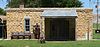 | October 8, 2009 (#09000810) | ½ block west of Baird St. on Lynn St. 39°48′02″N 97°27′31″W / 39.800572°N 97.458699°W / 39.800572; -97.458699 (Cuba Blacksmith Shop) | Cuba | |
| 5 | East Riley Creek Bridge |  | January 4, 1990 (#89002176) | Over East Riley Creek, south of Belleville 39°47′17″N 97°37′58″W / 39.787939°N 97.632835°W / 39.787939; -97.632835 (East Riley Creek Bridge) | Belleville | |
| 6 | Pawnee Indian Village Site |  | May 14, 1971 (#71000325) | On K-266 and the Republican River 39°54′30″N 97°51′38″W / 39.908333°N 97.860556°W / 39.908333; -97.860556 (Pawnee Indian Village Site) | Republic | |
| 7 | Republic County Courthouse |  | April 26, 2002 (#02000393) | Bounded by M St., 18th St., N St., and 19th St. 39°49′05″N 97°37′24″W / 39.818056°N 97.623333°W / 39.818056; -97.623333 (Republic County Courthouse) | Belleville | |
| 8 | Riley Creek Bridge |  | January 4, 1990 (#89002175) | Over Riley Creek, south of Belleville 39°47′16″N 97°37′56″W / 39.787778°N 97.632222°W / 39.787778; -97.632222 (Riley Creek Bridge) | Belleville | |
| 9 | Shimanek Barn |  | April 8, 2009 (#09000194) | 1806 220 Road 39°54′03″N 97°32′20″W / 39.900889°N 97.538936°W / 39.900889; -97.538936 (Shimanek Barn) | Munden | Agriculture-Related Resources of Kansas MPS |
| 10 | Site No. JF00-072 |  | June 19, 1987 (#87001000) | Junction of Thayer, Jefferson, Washington, and Republic County lines 40°00′07″N 97°22′09″W / 40.00198°N 97.3692°W / 40.00198; -97.3692 (Site No. JF00-072) | Mahaska | |
| 11 | S.T. Stevenson House |  | July 8, 2010 (#10000451) | 2012 N St. 39°49′18″N 97°37′45″W / 39.821667°N 97.629167°W / 39.821667; -97.629167 (S.T. Stevenson House) | Belleville | |
| 12 | US Post Office-Belleville |  | October 17, 1989 (#89001633) | 1119 18th St. 39°49′28″N 97°37′57″W / 39.824444°N 97.6325°W / 39.824444; -97.6325 (US Post Office-Belleville) | Belleville | |
| 13 | Woodland Place Stock Farm |  | December 29, 2015 (#15000938) | 180 Hickory Rd. 39°54′00″N 97°55′02″W / 39.900000°N 97.917222°W / 39.900000; -97.917222 (Woodland Place Stock Farm) | Courtland |
See also
Wikimedia Commons has media related to National Register of Historic Places in Republic County, Kansas.
- List of National Historic Landmarks in Kansas
- National Register of Historic Places listings in Kansas
References
- ^ The latitude and longitude information provided in this table was derived originally from the National Register Information System, which has been found to be fairly accurate for about 99% of listings. Some locations in this table may have been corrected to current GPS standards.
- ^ National Park Service, United States Department of the Interior, "National Register of Historic Places: Weekly List Actions", retrieved June 7, 2024.
- ^ Numbers represent an alphabetical ordering by significant words. Various colorings, defined here, differentiate National Historic Landmarks and historic districts from other NRHP buildings, structures, sites or objects.
- ^ "National Register Information System". National Register of Historic Places. National Park Service. March 13, 2009.
- ^ The eight-digit number below each date is the number assigned to each location in the National Register Information System database, which can be viewed by clicking the number.
- v
- t
- e

- Allen
- Anderson
- Atchison
- Barber
- Barton
- Bourbon
- Brown
- Butler
- Chase
- Chautauqua
- Cherokee
- Cheyenne
- Clark
- Clay
- Cloud
- Coffey
- Comanche
- Cowley
- Crawford
- Decatur
- Dickinson
- Doniphan
- Douglas
- Edwards
- Elk
- Ellis
- Ellsworth
- Finney
- Ford
- Franklin
- Geary
- Gove
- Graham
- Grant
- Gray
- Greeley
- Greenwood
- Hamilton
- Harper
- Harvey
- Haskell
- Hodgeman
- Jackson
- Jefferson
- Jewell
- Johnson
- Kearny
- Kingman
- Kiowa
- Labette
- Lane
- Leavenworth
- Lincoln
- Linn
- Logan
- Lyon
- Marion
- McPherson
- Meade
- Miami
- Mitchell
- Montgomery
- Morris
- Morton
- Nemaha
- Neosho
- Ness
- Norton
- Osage
- Osborne
- Ottawa
- Pawnee
- Phillips
- Pottawatomie
- Pratt
- Rawlins
- Reno
- Republic
- Rice
- Riley
- Rooks
- Rush
- Russell
- Saline
- Scott
- Sedgwick
- Seward
- Shawnee
- Sheridan
- Sherman
- Smith
- Stafford
- Stanton
- Stevens
- Sumner
- Thomas
- Trego
- Wabaunsee
- Wallace
- Washington
- Wichita
- Wilson
- Woodson
- Wyandotte
- Archaeological sites
- National Historic Landmarks
 Category
 NRHP portal


Municipalities and communities of Republic County, Kansas, United States | ||
|---|---|---|
County seat: Belleville | ||
| Cities |  | |
| Unincorporated communities | ||
| Ghost towns | ||
| Townships | ||
| Footnotes | †This community is designated a Census-Designated Place (CDP) by the United States Census Bureau. | |
| ||


