Nuweiba
You can help expand this article with text translated from the corresponding article in Arabic. (April 2019) Click [show] for important translation instructions.
- Machine translation, like DeepL or Google Translate, is a useful starting point for translations, but translators must revise errors as necessary and confirm that the translation is accurate, rather than simply copy-pasting machine-translated text into the English Wikipedia.
- Do not translate text that appears unreliable or low-quality. If possible, verify the text with references provided in the foreign-language article.
- You must provide copyright attribution in the edit summary accompanying your translation by providing an interlanguage link to the source of your translation. A model attribution edit summary is
Content in this edit is translated from the existing Arabic Wikipedia article at [[:ar:نويبع]]; see its history for attribution. - You may also add the template
{{Translated|ar|نويبع}}to the talk page. - For more guidance, see Wikipedia:Translation.
Coastal town in South Sinai, Egypt
Nuweiba نويبع | |
|---|---|
coastal town | |
     Overview of Nuweiba | |
| 29°2′N 34°40′E / 29.033°N 34.667°E / 29.033; 34.667 | |
| Country |  Egypt Egypt |
| Governorate | South Sinai |
| Time zone | UTC+2 (EST) |
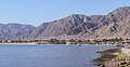
Nuweiba (also spelled: Nueiba; Arabic: نويبع, IPA: [neˈweːbeʕ]) is a coastal town in the eastern part of Sinai Peninsula, Egypt, located on the coast of the Gulf of Aqaba.
History
Historically, it is in the Asian part of Egypt, and the area was inhabited by two different ancient Bedouin tribes: the Tarabin to the north, and the Muzeina some 8 km (5 mi) to the south. After the Six-Day War when Israel occupied the area, a small town was established just 1.5 km (1 mi) south of Tarabeen under the Hebrew name of Neviot (Hebrew: נביעות). After the departure of the Israelis, former Egyptian President Hosni Mubarak expanded the settlement. Nuweiba Port, some 7 km (4 mi) to the south, was established and developed,[1] with several car ferries running every day to Aqaba in Jordan by the Arab Bridge Maritime company, and with a small town growing up around it.
Nuweiba castle (or Newibah castle), built on top of the remains of a still older castle in 1893, has been proposed as a UNESCO World Heritage site.[2]
Geography
Nuweiba lies on a large flood plain measuring about 40 km2 (15 sq mi), sandwiched between the Sinai mountains and the Gulf of Aqaba, and is located some 150 km (90 mi) north of Sharm el Sheikh, 465 km (290 mi) southeast from Cairo and 70 km (40 mi) south of the Israel–Egypt border separating Taba and Eilat. Nuweiba Port was built in 1985 on the Gulf of Aqaba, and serves as a ferry port as well, facilitating between Jordan and Egypt.
Climate
Köppen-Geiger climate classification system classifies its climate as hot desert (BWh).
Most precipitation falls in February.[3]
| Climate data for Nuweiba | |||||||||||||
|---|---|---|---|---|---|---|---|---|---|---|---|---|---|
| Month | Jan | Feb | Mar | Apr | May | Jun | Jul | Aug | Sep | Oct | Nov | Dec | Year |
| Mean daily maximum °C (°F) | 20.8 (69.4) | 22.5 (72.5) | 25.4 (77.7) | 29.2 (84.6) | 32.9 (91.2) | 35.7 (96.3) | 36.5 (97.7) | 36.8 (98.2) | 34.4 (93.9) | 31.3 (88.3) | 26.6 (79.9) | 22.1 (71.8) | 29.5 (85.1) |
| Daily mean °C (°F) | 15.6 (60.1) | 16.9 (62.4) | 19.7 (67.5) | 23.2 (73.8) | 26.3 (79.3) | 29.5 (85.1) | 30.7 (87.3) | 30.9 (87.6) | 29.0 (84.2) | 25.8 (78.4) | 21.3 (70.3) | 16.8 (62.2) | 23.8 (74.9) |
| Mean daily minimum °C (°F) | 10.4 (50.7) | 11.3 (52.3) | 14.0 (57.2) | 17.3 (63.1) | 19.8 (67.6) | 23.4 (74.1) | 25.0 (77.0) | 25.1 (77.2) | 23.7 (74.7) | 20.3 (68.5) | 16.0 (60.8) | 11.6 (52.9) | 18.2 (64.7) |
| Average precipitation mm (inches) | 1 (0.0) | 3 (0.1) | 3 (0.1) | 1 (0.0) | 0 (0) | 0 (0) | 0 (0) | 0 (0) | 0 (0) | 1 (0.0) | 2 (0.1) | 2 (0.1) | 13 (0.4) |
| Average rainy days | 2 | 1 | 2 | 1 | 1 | 0 | 0 | 0 | 0 | 1 | 1 | 1 | 10 |
| Mean daily sunshine hours | 8 | 9 | 9 | 10 | 11 | 13 | 13 | 12 | 11 | 10 | 9 | 8 | 10 |
| Source 1: Climate-Data.org[3] | |||||||||||||
| Source 2: Weather2Travel[4] for rainy days and sunshine | |||||||||||||
| Jan | Feb | Mar | Apr | May | Jun | Jul | Aug | Sep | Oct | Nov | Dec |
|---|---|---|---|---|---|---|---|---|---|---|---|
| 22 °C (72 °F) | 21 °C (70 °F) | 21 °C (70 °F) | 23 °C (73 °F) | 25 °C (77 °F) | 26 °C (79 °F) | 28 °C (82 °F) | 28 °C (82 °F) | 28 °C (82 °F) | 27 °C (81 °F) | 25 °C (77 °F) | 23 °C (73 °F) |
Tourism
Between the town and the port are a strip of modern hotels, catering to beach holiday makers and divers. One km north of Nuweiba City, Tarabin village is well known for its Bedouin-style camps where cheap huts are available for rent. Further north, in the direction of Taba, are several other beaches with similar accommodation options.
Gallery
-
 View of the coast, Nuweiba Tarabin
 -
 The beach of Nuweiba
 -
 Beach shack
 -
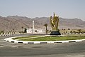 Roundabout
 -
 Desert near Nuweiba
 -
 Goats on the road
 -
 Camel near Nuweiba
 -
 Camels roaming through Nuweiba


See also
References
- ^ "Nuwaiba port". Maritime Transport Sector - Government of Egypt. Retrieved 17 September 2018.
- ^ Newibah castle - UNESCO World Heritage Centre Retrieved on 2009-03-26
- ^ a b "Climate: Nueiba - Climate graph, Temperature graph, Climate table". Climate-Data.org. Retrieved 15 August 2013.
- ^ a b "Nuweiba Climate and Weather Averages, Egypt". Weather2Travel. Archived from the original on 5 January 2014. Retrieved 15 August 2013.
External links
Wikivoyage has a travel guide for Nuweiba.
- v
- t
- e
Egyptian cities and towns by population- 6th of October
- Arish
- Aswan
- Benha
- Beni Suef
- Damanhur
- Desouk
- Edfu
- Hurghada
- Kafr El Dawwar
- Kafr El Sheikh
- Mallawi
- Minya
- New Borg El Arab
- New Cairo
- Obour
- Qena
- Shibin El Kom
- Sohag


