Ondrejovce
Village in Slovakia
Ondrejovce Barsendréd | |
|---|---|
Village | |
 | |
| 48°08′N 18°31′E / 48.133°N 18.517°E / 48.133; 18.517 | |
| Country | Slovakia |
| Region | Nitra |
| District | Levice |
| First mentioned | 1260 |
| Area | |
| • Total | 19.61[2] km2 (7.57[2] sq mi) |
| Elevation | 159[3] m (522[3] ft) |
| Population (2021) | |
| • Total | 441[1] |
| Postal code | 935 51[3] |
| Area code | +421 36[3] |
| Car plate | LV |
| Website | www.obecondrejovce.sk |
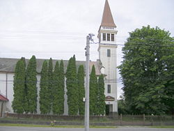
Ondrejovce (Hungarian: Barsendréd) is a village and municipality in the Levice District in the Nitra Region of Slovakia.
History
In historical records the village was first mentioned in 1260.
Geography
The village lies at an altitude of 163 metres and covers an area of 19.611 km². It has a population of about 470 people.
Ethnicity
The village is approximately 62% Slovak and 37% Magyar and 1% Gypsy.
Facilities
The village has a public library and football pitch.
References
- ^ "Počet obyvateľov podľa pohlavia - obce (ročne)". www.statistics.sk (in Slovak). Statistical Office of the Slovak Republic. 2022-03-31. Retrieved 2022-03-31.
- ^ a b "Hustota obyvateľstva - obce [om7014rr_ukaz: Rozloha (Štvorcový meter)]". www.statistics.sk (in Slovak). Statistical Office of the Slovak Republic. 2022-03-31. Retrieved 2022-03-31.
- ^ a b c d "Základná charakteristika". www.statistics.sk (in Slovak). Statistical Office of the Slovak Republic. 2015-04-17. Retrieved 2022-03-31.
- ^ a b "Hustota obyvateľstva - obce". www.statistics.sk (in Slovak). Statistical Office of the Slovak Republic. 2022-03-31. Retrieved 2022-03-31.
External links
- http://www.obecondrejovce.sk
- v
- t
- e
Municipalities of Levice District
- Bajka
- Bátovce
- Beša
- Bielovce
- Bohunice
- Bory
- Brhlovce
- Čajkov
- Čaka
- Čata
- Demandice
- Devičany
- Dolná Seč
- Dolné Semerovce
- Dolný Pial
- Domadice
- Drženice
- Farná
- Hokovce
- Hontianska Vrbica
- Hontianske Trsťany
- Horná Seč
- Horné Semerovce
- Horné Turovce
- Horný Pial
- Hrkovce
- Hronovce
- Hronské Kľačany
- Hronské Kosihy
- Iňa
- Ipeľské Úľany
- Ipeľský Sokolec
- Jabloňovce
- Jesenské
- Jur nad Hronom
- Kalná nad Hronom
- Keť
- Kozárovce
- Krškany
- Kubáňovo
- Kukučínov
- Kuraľany
- Lok
- Lontov
- Lula
- Málaš
- Malé Kozmálovce
- Malé Ludince
- Mýtne Ludany
- Nová Dedina
- Nový Tekov
- Nýrovce
- Ondrejovce
- Pastovce
- Pečenice
- Plášťovce
- Plavé Vozokany
- Podlužany
- Pohronský Ruskov
- Pukanec
- Rybník
- Santovka
- Sazdice
- Sikenica
- Slatina
- Starý Hrádok
- Starý Tekov
- Šalov
- Šarovce
- Tehla
- Tekovské Lužany
- Tekovský Hrádok
- Tupá
- Turá
- Uhliská
- Veľké Kozmálovce
- Veľké Ludince
- Veľké Turovce
- Veľký Ďur
- Vyškovce nad Ipľom
- Vyšné nad Hronom
- Zalaba
- Zbrojníky
- Žemberovce
- Žemliare

 | This Levice District geography article is a stub. You can help Wikipedia by expanding it. |
- v
- t
- e


