Oudon
Commune in Pays de la Loire, France

Coat of arms
Location of Oudon

(2020–2026) Alain Bourgoin[1]
1
(2021)[2]
44115 /44521
Oudon (French pronunciation: [udɔ̃] ⓘ) is a commune in the Loire-Atlantique department in western France.
Population
|
| ||||||||||||||||||||||||||||||||||||||||||||||||||||||
| Source: EHESS[3] and INSEE (1968-2017)[4] | |||||||||||||||||||||||||||||||||||||||||||||||||||||||
Gallery
-
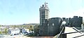 Oudon Castle
 -
 Menhir of "Pierre blanche"


Town twinning
 Batheaston, Somerset, Great Britain

References
- ^ "Répertoire national des élus: les maires" (in French). data.gouv.fr, Plateforme ouverte des données publiques françaises. 13 September 2022.
- ^ "Populations légales 2021". The National Institute of Statistics and Economic Studies. 28 December 2023.
- ^ Des villages de Cassini aux communes d'aujourd'hui: Commune data sheet Oudon, EHESS (in French).
- ^ Population en historique depuis 1968, INSEE
See also
Wikimedia Commons has media related to Oudon.
- v
- t
- e
Communes of the Loire-Atlantique department 

- Abbaretz
- Aigrefeuille-sur-Maine
- Ancenis-Saint-Géréon
- Assérac
- Avessac
- Basse-Goulaine
- Batz-sur-Mer
- La Baule-Escoublac
- La Bernerie-en-Retz
- Besné
- Le Bignon
- Blain
- La Boissière-du-Doré
- Bouaye
- Bouée
- Bouguenais
- Boussay
- Bouvron
- Brains
- Campbon
- Carquefou
- Casson
- Le Cellier
- La Chapelle-des-Marais
- La Chapelle-Glain
- La Chapelle-Heulin
- La Chapelle-Launay
- La Chapelle-sur-Erdre
- Châteaubriantsubpr
- Château-Thébaud
- Chaumes-en-Retz
- Chauvé
- Cheix-en-Retz
- La Chevallerais
- La Chevrolière
- Clisson
- Conquereuil
- Corcoué-sur-Logne
- Cordemais
- Corsept
- Couëron
- Couffé
- Le Croisic
- Crossac
- Derval
- Divatte-sur-Loire
- Donges
- Drefféac
- Erbray
- Fay-de-Bretagne
- Fégréac
- Fercé
- Frossay
- Le Gâvre
- Geneston
- Gétigné
- Gorges
- Grand-Auverné
- Grandchamp-des-Fontaines
- La Grigonnais
- Guémené-Penfao
- Guenrouet
- Guérande
- La Haie-Fouassière
- Haute-Goulaine
- Herbignac
- Héric
- Indre
- Issé
- Jans
- Joué-sur-Erdre
- Juigné-des-Moutiers
- Le Landreau
- Lavau-sur-Loire
- Legé
- Ligné
- La Limouzinière
- Loireauxence
- Le Loroux-Bottereau
- Louisfert
- Lusanger
- Machecoul-Saint-Même
- Maisdon-sur-Sèvre
- Malville
- La Marne
- Marsac-sur-Don
- Massérac
- Mauves-sur-Loire
- La Meilleraye-de-Bretagne
- Mésanger
- Mesquer
- Missillac
- Moisdon-la-Rivière
- Monnières
- La Montagne
- Montbert
- Montoir-de-Bretagne
- Montrelais
- Mouais
- Les Moutiers-en-Retz
- Mouzeil
- Mouzillon
- Nantespref
- Nort-sur-Erdre
- Notre-Dame-des-Landes
- Noyal-sur-Brutz
- Nozay
- Orvault
- Oudon
- Paimbœuf
- Le Pallet
- Pannecé
- Paulx
- Le Pellerin
- Petit-Auverné
- Petit-Mars
- Pierric
- Le Pin
- Piriac-sur-Mer
- La Plaine-sur-Mer
- La Planche
- Plessé
- Pont-Saint-Martin
- Pontchâteau
- Pornic
- Pornichet
- Port-Saint-Père
- Pouillé-les-Côteaux
- Le Pouliguen
- Préfailles
- Prinquiau
- Puceul
- Quilly
- La Regrippière
- La Remaudière
- Remouillé
- Rezé
- Riaillé
- La Roche-Blanche
- Rouans
- Rougé
- Ruffigné
- Saffré
- Saint-Aignan-Grandlieu
- Saint-André-des-Eaux
- Saint-Aubin-des-Châteaux
- Saint-Brevin-les-Pins
- Saint-Colomban
- Sainte-Anne-sur-Brivet
- Sainte-Luce-sur-Loire
- Sainte-Pazanne
- Sainte-Reine-de-Bretagne
- Saint-Étienne-de-Mer-Morte
- Saint-Étienne-de-Montluc
- Saint-Fiacre-sur-Maine
- Saint-Gildas-des-Bois
- Saint-Herblain
- Saint-Hilaire-de-Chaléons
- Saint-Hilaire-de-Clisson
- Saint-Jean-de-Boiseau
- Saint-Joachim
- Saint-Julien-de-Concelles
- Saint-Julien-de-Vouvantes
- Saint-Léger-les-Vignes
- Saint-Lumine-de-Clisson
- Saint-Lumine-de-Coutais
- Saint-Lyphard
- Saint-Malo-de-Guersac
- Saint-Mars-de-Coutais
- Saint-Mars-du-Désert
- Saint-Michel-Chef-Chef
- Saint-Molf
- Saint-Nazairesubpr
- Saint-Nicolas-de-Redon
- Saint-Père-en-Retz
- Saint-Philbert-de-Grand-Lieu
- Saint-Sébastien-sur-Loire
- Saint-Viaud
- Saint-Vincent-des-Landes
- Sautron
- Savenay
- Sévérac
- Sion-les-Mines
- Soudan
- Les Sorinières
- Soulvache
- Sucé-sur-Erdre
- Teillé
- Le Temple-de-Bretagne
- Thouaré-sur-Loire
- Les Touches
- Touvois
- Trans-sur-Erdre
- Treffieux
- Treillières
- Trignac
- La Turballe
- Vair-sur-Loire
- Vallet
- Vallons-de-l'Erdre
- Vay
- Vertou
- Vieillevigne
- Vigneux-de-Bretagne
- Villeneuve-en-Retz
- Villepot
- Vue
- pref: prefecture
- subpr: subprefecture
Authority control databases | |
|---|---|
| International |
|
| National |
|
 | This Loire-Atlantique geographical article is a stub. You can help Wikipedia by expanding it. |
- v
- t
- e


