Pasargad County
County in Fars province, Iran
County in Fars, Iran
Pasargad County Persian: شهرستان پاسارگاد | |
|---|---|
County | |
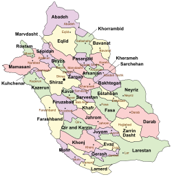 Location of Pasargad County in Fars province (top center, purple) | |
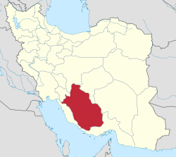 Location of Fars province in Iran | |
| Coordinates: 30°10′N 53°09′E / 30.167°N 53.150°E / 30.167; 53.150[1] | |
| Country |  Iran Iran |
| Province | Fars |
| Capital | Saadat Shahr |
| Districts | Central, Pasargad |
| Population (2016)[2] | |
| • Total | 30,118 |
| Time zone | UTC+3:30 (IRST) |
Pasargad County (Persian: شهرستان پاسارگاد) is in Fars province, Iran. Its capital is the city of Saadat Shahr.[3]
At the 2006 census, the county's population was 29,825 in 7,100 households.[4] The following census in 2011 counted 31,504 people in 8,364 households.[5] At the 2016 census, the county's population was 30,118 in 8,813 households.[2]
Administrative divisions
The population history and structural changes of Pasargad County's administrative divisions over three consecutive censuses are shown in the following table. The latest census shows two districts, four rural districts, and two cities.[2]
| Administrative Divisions | 2006[4] | 2011[5] | 2016[2] |
|---|---|---|---|
| Central District | 23,654 | 24,962 | 23,955 |
| Kamin RD | 5,522 | 6,229 | 5,399 |
| Sarpaniran RD | 2,185 | 1,857 | 1,425 |
| Saadat Shahr (city) | 15,947 | 16,876 | 17,131 |
| Pasargad District[a] | 6,171 | 6,527 | 6,161 |
| Abu ol Verdi RD | 2,451 | 2,455 | 2,739 |
| Madar-e Soleyman RD | 3,720 | 4,072 | 1,876 |
| Madar-e Soleyman (city) | 1,546 | ||
| Total | 29,825 | 31,504 | 30,118 |
| RD = Rural District | |||
Wikimedia Commons has media related to Pasargad County.
 Iran portal

Notes
References
- ^ OpenStreetMap contributors (27 September 2023). "Pasargad County" (Map). OpenStreetMap. Retrieved 27 September 2023.
- ^ a b c d "Census of the Islamic Republic of Iran, 1395 (2016)". AMAR (in Persian). The Statistical Center of Iran. p. 07. Archived from the original (Excel) on 6 April 2022. Retrieved 19 December 2022.
- ^ Aref, Mohammad Reza (29 January 1384). "Divisional reforms in Fars province (Mashhad Morghab District, Mader-e Soleyman District, Abu ol Verdi District, Hakhamanish District, Pasargad County)". Qavanin (in Persian). Ministry of Interior, Political-Defense Commission of the Government Board. Archived from the original on 9 October 2021. Retrieved 10 December 2023.
- ^ a b "Census of the Islamic Republic of Iran, 1385 (2006)". AMAR (in Persian). The Statistical Center of Iran. p. 07. Archived from the original (Excel) on 20 September 2011. Retrieved 25 September 2022.
- ^ a b "Census of the Islamic Republic of Iran, 1390 (2011)". Syracuse University (in Persian). The Statistical Center of Iran. p. 07. Archived from the original (Excel) on 16 January 2023. Retrieved 19 December 2022.
- ^ Davoodi, Parviz (1 October 2017). "Changing the name of Hakhamanish District under Pasargad County in Fars province to Pasargad District". Qavanin (in Persian). Ministry of Interior, Political and Defense Commission. Archived from the original on 28 September 2023. Retrieved 28 September 2023.
- v
- t
- e
Fars Province, Iran

and cities
- Afif-Abad Garden
- Amir's dam
- Arg of Karim Khan
- Barmdelak lagoon
- Bishapur
- Delgosha Garden
- Eram Garden
- Istakhr
- Ghal'eh Dokhtar
- Ka'ba-ye Zartosht
- Kazerun fire temple
- Lake Parishan
- Naqsh-e Rajab
- Naqsh-e Rustam
- Palace of Ardashir
- Sangtarashan cave
- Pars Museum
- Pasargadae
- Persepolis
- Qavam House
- Qur'an Gate
- Saadi's mausoleum
- Sarvestan Sassanian palace
- Shah Cheragh
- Colossal Statue of Shapur I in Shapur cave
- Tangeh Bolaghi
- Tomb of Ali ibn Hamzah, Shiraz
- Hāfezieh
- Tomb of Seyed Alaeddin Husayn
- Tounbbot
- Vakil Bath
- Vakil Bazaar
- Vakil Mosque
Pasargad County | |||||||||||||||||||||
|---|---|---|---|---|---|---|---|---|---|---|---|---|---|---|---|---|---|---|---|---|---|
| Capital | |||||||||||||||||||||
| Districts |
| ||||||||||||||||||||
 | This Fars Province location article is a stub. You can help Wikipedia by expanding it. |
- v
- t
- e


