Pau dos Ferros
The Municipality of Pau dos Ferros in Nordeste, Brazil

Flag

Seal
Princesinha do Oeste (Princess of the West) and PDF
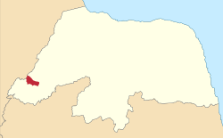
Location in the state of Rio Grande do Norte.
 Brazil
 (2020 [3])
59900-000
Pau dos Ferros is a municipality in the homonymous microregion, in Rio Grande do Norte state, Northeast Brazil.[4]
History
The city was founded on September 4, 1856, initially as a village and then the town today is a city that has as its main form of economy the industrial sector and to a lesser extent agriculture.[5]
See also
References
- ^ "Área Territorial Brasileira - Consulta por Município" (in Portuguese). Brazilian Institute of Geography and Statistics. January 15, 2013. Archived from the original on June 3, 2015. Retrieved August 17, 2015.
- ^ "Latitude e Longitude das cidades Brasileiras" (in Portuguese). Archived from the original on August 18, 2015. Retrieved February 3, 2017.
- ^ IBGE 2020
- ^ "Divisão Territorial do Brasil" (in Portuguese). Divisão Territorial do Brasil e Limites Territoriais, Instituto Brasileiro de Geografia e Estatística (IBGE). July 1, 2008. Retrieved December 17, 2009.
- ^ Pau dos Ferros History in Portuguese
Authority control databases | |
|---|---|
| International |
|
| National |
|
- v
- t
- e


