Penfield, Pennsylvania
Unincorporated community in Pennsylvania, United States
41°12′30″N 78°34′32″W / 41.20833°N 78.57556°W / 41.20833; -78.5755615849
Penfield is an unincorporated community that is located in Clearfield County, Pennsylvania, United States.[1]
Geography and notable features
The community is situated at the intersection of Pennsylvania Route 153 and Pennsylvania Route 255, 11.3 miles (18.2 km) east-northeast of DuBois.
Penfield has a post office with ZIP code 15849.[2][3]
Gallery
-
 Presbyterian church, 1907 postcard
 -
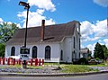 Former Presbyterian church, 2007


References
- ^ a b "Penfield". Geographic Names Information System. United States Geological Survey, United States Department of the Interior.
- ^ United States Postal Service. "USPS - Look Up a ZIP Code". Retrieved April 5, 2015.
- ^ "Postmaster Finder - Post Offices by ZIP Code". United States Postal Service. Retrieved April 5, 2015.
- v
- t
- e
Municipalities and communities of Clearfield County, Pennsylvania, United States
County seat: Clearfield
- Allport
- Bigler
- Blain City
- Drifting
- Frenchville
- Glen Richey
- Grassflat
- Hawk Run
- Hyde
- Karthaus
- Kylertown
- Lanse
- Luthersburg
- Madera
- Mineral Springs
- Morrisdale
- Oklahoma
- Penfield
- Plymptonville
- Rosebud
- Sandy
- Treasure Lake
- West Decatur
- Winburne
- Woodland
communities
‡This populated place also has portions in an adjacent county or counties
- Pennsylvania portal
- United States portal
| Authority control databases: Geographic |
|
|---|
 | This Clearfield County, Pennsylvania state location article is a stub. You can help Wikipedia by expanding it. |
- v
- t
- e


