Quỳnh Nhai district
You can help expand this article with text translated from the corresponding article in Vietnamese. (March 2009) Click [show] for important translation instructions.
- View a machine-translated version of the Vietnamese article.
- Machine translation, like DeepL or Google Translate, is a useful starting point for translations, but translators must revise errors as necessary and confirm that the translation is accurate, rather than simply copy-pasting machine-translated text into the English Wikipedia.
- Do not translate text that appears unreliable or low-quality. If possible, verify the text with references provided in the foreign-language article.
- You must provide copyright attribution in the edit summary accompanying your translation by providing an interlanguage link to the source of your translation. A model attribution edit summary is
Content in this edit is translated from the existing Vietnamese Wikipedia article at [[:vi:Quỳnh Nhai]]; see its history for attribution. - You may also add the template
{{Translated|vi|Quỳnh Nhai}}to the talk page. - For more guidance, see Wikipedia:Translation.
District in Northwest, Vietnam
Quỳnh Nhai district Huyện Quỳnh Nhai | |
|---|---|
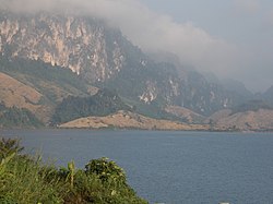 View between Chiềng Ơn mountain and sea | |
| Seal | |
| Country |  Vietnam Vietnam |
| Region | Northwest |
| Province | Sơn La province |
| Capital | Quỳnh Nhai |
| Area | |
| • Total | 405 sq mi (1,049 km2) |
| Population (2003) | |
| • Total | 62,189 |
| Time zone | UTC+7 (UTC + 7) |
Quỳnh Nhai is a district (huyện) of Sơn La province in the Northwest region of Vietnam.
As of 2003 the district had a population of 62,189.[1] The district covers an area of 1,049 km². The district capital lies at Quỳnh Nhai.[1]
Climate
| Climate data for Quỳnh Nhai, elevation 802 m (2,631 ft) | |||||||||||||
|---|---|---|---|---|---|---|---|---|---|---|---|---|---|
| Month | Jan | Feb | Mar | Apr | May | Jun | Jul | Aug | Sep | Oct | Nov | Dec | Year |
| Record high °C (°F) | 34.1 (93.4) | 38.0 (100.4) | 40.1 (104.2) | 40.5 (104.9) | 41.0 (105.8) | 38.7 (101.7) | 38.3 (100.9) | 39.0 (102.2) | 37.8 (100.0) | 36.5 (97.7) | 34.8 (94.6) | 37.6 (99.7) | 41.0 (105.8) |
| Mean daily maximum °C (°F) | 22.8 (73.0) | 25.3 (77.5) | 28.6 (83.5) | 31.6 (88.9) | 32.9 (91.2) | 32.3 (90.1) | 32.0 (89.6) | 32.3 (90.1) | 32.0 (89.6) | 30.1 (86.2) | 26.8 (80.2) | 23.8 (74.8) | 29.2 (84.6) |
| Daily mean °C (°F) | 16.8 (62.2) | 18.6 (65.5) | 21.8 (71.2) | 24.9 (76.8) | 26.8 (80.2) | 27.3 (81.1) | 27.2 (81.0) | 27.1 (80.8) | 26.3 (79.3) | 24.1 (75.4) | 20.6 (69.1) | 17.3 (63.1) | 23.2 (73.8) |
| Mean daily minimum °C (°F) | 13.6 (56.5) | 14.9 (58.8) | 17.6 (63.7) | 20.9 (69.6) | 23.1 (73.6) | 24.4 (75.9) | 24.5 (76.1) | 24.3 (75.7) | 23.3 (73.9) | 21.0 (69.8) | 17.5 (63.5) | 14.0 (57.2) | 19.9 (67.8) |
| Record low °C (°F) | 0.9 (33.6) | 5.4 (41.7) | 6.5 (43.7) | 12.8 (55.0) | 16.6 (61.9) | 18.6 (65.5) | 20.9 (69.6) | 20.6 (69.1) | 16.3 (61.3) | 11.8 (53.2) | 7.4 (45.3) | 3.5 (38.3) | 0.9 (33.6) |
| Average precipitation mm (inches) | 30.7 (1.21) | 28.4 (1.12) | 58.8 (2.31) | 133.8 (5.27) | 205.6 (8.09) | 291.7 (11.48) | 356.1 (14.02) | 314.2 (12.37) | 153.0 (6.02) | 75.7 (2.98) | 42.6 (1.68) | 25.0 (0.98) | 1,717.1 (67.60) |
| Average rainy days | 4.4 | 4.1 | 6.6 | 12.2 | 15.6 | 19.4 | 20.8 | 18.9 | 11.7 | 7.8 | 5.1 | 3.1 | 129.7 |
| Average relative humidity (%) | 83.2 | 80.0 | 79.1 | 80.0 | 82.0 | 85.6 | 87.0 | 86.7 | 86.1 | 85.4 | 84.7 | 83.9 | 83.6 |
| Mean monthly sunshine hours | 107.6 | 117.6 | 114.3 | 176.6 | 186.1 | 128.1 | 132.8 | 155.6 | 163.8 | 153.5 | 130.3 | 126.0 | 1,720.5 |
| Source: Vietnam Institute for Building Science and Technology[2] | |||||||||||||
References
- ^ a b "Districts of Vietnam". Statoids. Retrieved March 13, 2009.
- ^ "Vietnam Institute for Building Science and Technology" (PDF). Retrieved 16 August 2023.
21°49′59″N 103°40′01″E / 21.833°N 103.667°E / 21.833; 103.667
- v
- t
- e
Districts of Northwest Vietnam

※ denotes provincial seat.
Authority control databases | |
|---|---|
| International |
|
| National |
|
 | This article about a location in Sơn La Province, Vietnam is a stub. You can help Wikipedia by expanding it. |
- v
- t
- e


