Roßleben
Ortsteil of Roßleben-Wiehe in Thuringia, Germany

Coat of arms
Location of Roßleben

51°17′52″N 11°26′0″E / 51.29778°N 11.43333°E / 51.29778; 11.43333
(2017-12-31)
06571
Roßleben is a town and a former municipality in the Kyffhäuserkreis district, with a population of 4,885 (2017). It is located in Thuringia, Germany. Since 1 January 2019, it is part of the town Roßleben-Wiehe. It is situated on the river Unstrut, 22 km southeast of Sangerhausen.
Population development
|
|
|
|
From 1999 with districts
Data source: Statistical office Thuringia
Sons and daughters of the town
- Fritz Hofmann, (1871-1927), athlete, sprinter, winner of the first medal for Germany at the Olympic Games 1896 in Athens
- Hugo Launicke, (1909-1975), antifascist and SED politician.
- Werner Heine (born 1935), footballer
- Richard Hüttig (1908-1934), communist, hanged on June 14, 1934 in Berlin-Plötzensee
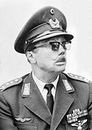
- Johannes Steinhoff (1913-1994), fighter pilot in the Second World War, general and inspector of the Luftwaffe in the Federal Republic of Germany
References
Authority control databases | |
|---|---|
| International |
|
| National |
|
- v
- t
- e


