Rome–Giardinetti railway
3 ft 1+3⁄8 in)Electrification 1,650 V DC, overhead lines
 Rome Metro
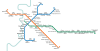
FL lines Local railways Urban surface systems Ticketing systems
Route map |
|---|
 |
Rome-Giardinetti | ||||||||||||||||||||||||||||||||||||||||||||||||||||||||||||||||||||||||||||||||||||||||||||||||||||||||||||||||||||||||||||||||||||||||||||||||||||||||||
|---|---|---|---|---|---|---|---|---|---|---|---|---|---|---|---|---|---|---|---|---|---|---|---|---|---|---|---|---|---|---|---|---|---|---|---|---|---|---|---|---|---|---|---|---|---|---|---|---|---|---|---|---|---|---|---|---|---|---|---|---|---|---|---|---|---|---|---|---|---|---|---|---|---|---|---|---|---|---|---|---|---|---|---|---|---|---|---|---|---|---|---|---|---|---|---|---|---|---|---|---|---|---|---|---|---|---|---|---|---|---|---|---|---|---|---|---|---|---|---|---|---|---|---|---|---|---|---|---|---|---|---|---|---|---|---|---|---|---|---|---|---|---|---|---|---|---|---|---|---|---|---|---|---|---|
Legend | ||||||||||||||||||||||||||||||||||||||||||||||||||||||||||||||||||||||||||||||||||||||||||||||||||||||||||||||||||||||||||||||||||||||||||||||||||||||||||
| ||||||||||||||||||||||||||||||||||||||||||||||||||||||||||||||||||||||||||||||||||||||||||||||||||||||||||||||||||||||||||||||||||||||||||||||||||||||||||


The Roma–Giardinetti railway is a narrow gauge on-street railway which connects Laziali (a regional train station some 800 metres (2,625 ft) from Termini's main concourse) with Giardinetti to the east just past the Grande Raccordo Anulare, Rome's orbital motorway.[1] It is run by ATAC, the company responsible for public transportation in the city, which also operates the Rome Metro.[2]
History
The present railway is the only part of the old and longer Rome–Fiuggi–Alatri–Frosinone railway to be in service. The latest shortening of the line occurred in 2008 with the closing of the Giardinetti–Pantano section, which has now become part of the Metro Line C.[3]
The line had been due to be dismantled in 2016 to be replaced with a bus lane along Via Casilina,[4] but in March 2015 it was announced that the line would instead be retained and modernised.[5]
References
- ^ "Il Libro Giallo del Trenino". CityRailways (in Italian). Retrieved 2015-04-22.
- ^ Piccirilli, Antonio (25 June 2013). "Un 'carro bestiame' nel cuore della città: quale futuro per la Roma-Giardinetti?". Roma Today (in Italian). Retrieved 2015-04-22.
- ^ "Metro C, apre la Pantano-Centocelle: folla di romani all'inaugurazione". Retrieved 2018-07-23.
- ^ Bisbiglia, Vincenzo (25 January 2015). "Trenino Roma-Giardinetti, la corsa è finita". Il Tempo (in Italian). Retrieved 2015-04-22.
- ^ Sina, Ylenia (19 March 2015). "La Roma Giardinetti devierà sulla Togliatti: destinazione Tor Vergata". Roma Today (in Italian). Retrieved 2015-04-22.
External links
- Atac official website
- Map of transport in Rome
- v
- t
- e
Urban transport in Rome


 Rome–Giardinetti
 Rome–Lido
 Rome–Civita Castellana–Viterbo


- Tramway
- Trolleybuses
- Metrebus
 Urban public transport networks and systems in Italy Urban public transport networks and systems in Italy | |||||||
|---|---|---|---|---|---|---|---|
| Commuter rail |  | ||||||
| Rapid transit | |||||||
| Trams |
| ||||||
| Bus rapid transit | |||||||
| Trolleybuses |
| ||||||
| People movers | |||||||
41°51′53″N 12°36′16″E / 41.8647°N 12.6044°E / 41.8647; 12.6044


