Sacajawea Peak


Sacajawea Peak
Location in Oregon
Sacajawea Peak is a peak in the Wallowa Mountains, in the U.S. state of Oregon. It is in the Eagle Cap Wilderness and the Wallowa–Whitman National Forest.
Description
At 9,843 feet (3,000 m), Sacajawea Peak is the highest point in the Wallowa Mountains, and the 6th highest peak in Oregon.[1] Matterhorn, another peak in the Wallowa Mountains, is about the same height at Sacajawea Peak, and some sources claim it is actually slightly higher.[3]
Sacajawea's prominence of 6,377 feet (1,944 m),[1] makes it one of the most topographically prominent peaks in the United States. It is ranked 18th among peaks in the 48 contiguous states.[4] It is the 2nd most prominent peak in Oregon, after Mount Hood.[5]
The nearest peak higher than Sacajawea is Pinyon Peak, in the Rocky Mountains of Idaho, 126 mi (203 km) to the east.[1] This makes Sacajawea Peak the 25th most topographically isolated peak of the United States.[6]
Sacajawea Peak is the highest summit in the Eagle Cap Wilderness and the Wallowa–Whitman National Forest. It is just northwest of Hurwal Divide, 1 mile (1.6 km) north of Matterhorn, 1.4 miles (2.3 km) northwest of Ice Lake, and 8 miles (13 km) south of Joseph.
Sacajawea Peak is connected by high ridges to Matterhorn. Both are connected to Hurwal Divide, a high ridge extending east and north from Sacajawea and Matterhorn. A high pass connects Hurwal Divide to Chief Joseph Mountain, to the north. These mountains and high ridges form a unit separated from the rest of the Wallowas by river valleys, with the West Fork Wallowa River flows north along the east edge and Hurricane Creek along the west. Numerous tributaries flow from the high mountains to these rivers. Sacajawea Peak is closer to Hurricane Creek, and several tributary streams rise on the slopes of Sacajawea, such as Thorp Creek. To the west of Sacajawea Peak, across the valley of Hurricane Creek, is the high ridge of Hurricane Divide, which separates Hurricane Creek from Lostine River. South of the Sacajawea and Matterhorn high lands is Lake Basin, in which the Lostine River, West Fork Wallowa River, and Hurricane Creek originate among many small lakes. To the north and east of Sacajawea Peak and Chief Joseph Mountain the Wallowa Mountains come to an end at Wallowa Lake, just south of the town of Joseph. A road runs south from Joseph along the east side of Wallowa Lake and into the valley of the Wallowa River. A number of recreation opportunities are located there, south of Wallowa Lake, including Wallowa Lake State Park and the Wallowa Lake Tramway on Mount Howard.[7]
Climate
| Climate data for Sacajawea Peak 45.2435 N, 117.2904 W, Elevation: 9,222 ft (2,811 m) (1991–2020 normals) | |||||||||||||
|---|---|---|---|---|---|---|---|---|---|---|---|---|---|
| Month | Jan | Feb | Mar | Apr | May | Jun | Jul | Aug | Sep | Oct | Nov | Dec | Year |
| Mean daily maximum °F (°C) | 26.2 (−3.2) | 26.2 (−3.2) | 29.8 (−1.2) | 34.1 (1.2) | 42.8 (6.0) | 50.4 (10.2) | 62.3 (16.8) | 62.4 (16.9) | 54.4 (12.4) | 41.8 (5.4) | 30.4 (−0.9) | 24.8 (−4.0) | 40.5 (4.7) |
| Daily mean °F (°C) | 18.9 (−7.3) | 17.9 (−7.8) | 20.3 (−6.5) | 23.9 (−4.5) | 32.1 (0.1) | 39.0 (3.9) | 49.2 (9.6) | 49.4 (9.7) | 42.3 (5.7) | 31.9 (−0.1) | 22.9 (−5.1) | 17.8 (−7.9) | 30.5 (−0.9) |
| Mean daily minimum °F (°C) | 11.7 (−11.3) | 9.5 (−12.5) | 10.8 (−11.8) | 13.7 (−10.2) | 21.4 (−5.9) | 27.6 (−2.4) | 36.2 (2.3) | 36.5 (2.5) | 30.2 (−1.0) | 22.0 (−5.6) | 15.5 (−9.2) | 10.8 (−11.8) | 20.5 (−6.4) |
| Average precipitation inches (mm) | 8.90 (226) | 7.44 (189) | 8.24 (209) | 6.69 (170) | 5.12 (130) | 3.70 (94) | 1.17 (30) | 0.94 (24) | 1.73 (44) | 4.73 (120) | 7.96 (202) | 9.87 (251) | 66.49 (1,689) |
| Source: PRISM Climate Group[8] | |||||||||||||
History
Sacajawea Peak is named for Sacagawea, the Shoshone woman who traveled with the Lewis and Clark Expedition. A proposal to change the name Sacajawea Peak to Sacagawea Peak was submitted in February 1998. In December 1999, the proposal was rejected by the United States Board on Geographic Names.[2]
See also
 Mountains portal

Gallery
-
 North aspect
 -
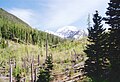
 Sacajawea Peak from Hurricane Creek Trail
 -
 Sacajawea Peak from Hurricane Creek Trail
 -
 Sacajawea Peak in upper right corner.
Matterhorn upper left, Ice Lake centered -
 Sacajawea Peak from Hurricane Creek Trail


References
- ^ a b c d e f "Sacajawea Peak, Oregon". Peakbagger.com. Retrieved 2009-06-14.
- ^ a b "Sacajawea Peak". Geographic Names Information System. United States Geological Survey, United States Department of the Interior. Retrieved 2016-04-27.
- ^ Barstad, Fred (2002). Oregon's Eagle Cap Wilderness. Globe Pequot. p. 298. ISBN 978-0-7627-2243-3.
- ^ "USA Lower 48 Top 100 Peaks by Prominence". Peakbagger.com. Retrieved 2012-04-01.
- ^ "Oregon Peaks with 2000 feet of Prominence". Peakbagger.com. Retrieved 2009-06-14.
- ^ "Most Isolated Peaks of the U.S. States". Peakbagger.com. Retrieved 2009-06-14.
- ^ USGS topographic maps
- ^ "PRISM Climate Group, Oregon State University". PRISM Climate Group, Oregon State University. Retrieved September 28, 2023.
To find the table data on the PRISM website, start by clicking Coordinates (under Location); copy Latitude and Longitude figures from top of table; click Zoom to location; click Precipitation, Minimum temp, Mean temp, Maximum temp; click 30-year normals, 1991-2020; click 800m; click Retrieve Time Series button.
External links
Wikimedia Commons has media related to Wallowa Mountains.
- "Sacajawea Peak". SummitPost.org. Retrieved 2011-05-07.
- v
- t
- e
- Denali
- Mauna Kea
- Mount Rainier
- Mount Fairweather
- Mount Blackburn
- Mount Hayes
- Mount Saint Elias
- Mount Marcus Baker
- Mount Whitney
- Haleakalā
- Mount Shasta
- Shishaldin Volcano
- Redoubt Volcano
- Mount Elbert
- Mount Baker
- Mount Torbert
- San Jacinto Peak
- San Gorgonio Mountain
- Charleston Peak
- Pavlof Volcano
- Mount Veniaminof
- Mount Adams
- Mount Hubbard
- Mount Isto
- Iliamna Volcano
- Mount Olympus
- Mount Cook
- Mount Hood
- Mount Sanford
- Mount Tom White
- Wheeler Peak
- Glacier Peak
- Mount Kimball
- Mount Griggs
- Mount Foraker
- White Mountain Peak
- Mount Crillon
- Mauna Loa
- Cloud Peak
- Gannett Peak
- Mount Vsevidof
- Mount Hesperus
- Mount Bona
- Mount Drum
- Mount Chiginagak
- Grand Teton
- Sacajawea Peak
- Mount Neacola
- Kings Peak
- Mount Graham
- Mount Douglas
- Mount San Antonio
- Kichatna Spire
- De Long Peak
- Telescope Peak
- Mount Peale
- Pogromni Volcano
- Dewey Peak
- Mount Washington
- Mount Igikpak
- Snow Tower
- Mount Mitchell
- Truuli Peak
- Humphreys Peak
- Borah Peak
- Mount Natazhat
- Hanagita Peak
- Tanaga Volcano
- Makushin Volcano
- Sovereign Mountain
- Mount Jefferson (Nevada)
- Mount Ellen
- Isanotski Peaks
- Deseret Peak
- Mount Jefferson (Oregon)
- Isthmus Peak
- Frosty Peak
- Pilot Peak
- Crazy Peak
- Great Sitkin Volcano
- Puʻu Kukui
- Mount Cleveland (Alaska)
- McDonald Peak
- Mount Wrangell
- South Sister
- Devils Paw
- Mount Seattle
- Sierra Blanca Peak
- Pikes Peak
- Mount Russell
- Mount Nebo
- Snowshoe Peak
- North Schell Peak
- Hayford Peak
- Mount Foresta
- Star Peak
- Veniaminof Peak
- Flat Top Mountain
- Bearhole Peak
- Mount Steller
- Mount Stuart
- Blanca Peak
- Mount Miller
- Carlisle Volcano
- Mount Timpanogos
- Bashful Peak
- Ibapah Peak
- Mount Cleveland (Montana)
- Kawaikini
- Tetlin Peak
- Arc Dome
- Lassen Peak
- Mount Deborah
- Necons Peak
- Abercrombie Mountain
- Mount Lemmon
- Mount Gareloi
- Chiricahua Peak
- Stony Peak
- Mount Eddy
- Mount Augusta
- Copper Peak
- Mount Bear
- Korovin Volcano
- Miller Peak
- Kamakou


