Santiurde de Toranzo
Municipality in Cantabria, Spain

Flag

Coat of arms

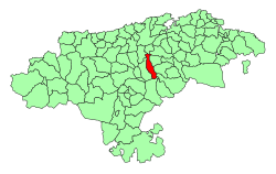
Location of the Municipality of Santiurde de Toranzo
 Spain
Spain Cantabria
 (2018)[1]
Santiurde de Toranzo is a municipality of Cantabria. The Pas River runs through it.
Towns within the municipality
- Acereda
- Bárcena
- Iruz
- Pando
- Penilla
- San Martín
- Santiurde de Toranzo (Capital)
- Vejorís
- Villasevil
References
- ^ Municipal Register of Spain 2018. National Statistics Institute.
External links
- (in Spanish) Ayunt. de Santiurde Toranzo
- v
- t
- e
Municipalities of Cantabria
- Alfoz de Lloredo
- Ampuero
- Anievas
- Arenas de Iguña
- Argoños
- Arnuero
- Arredondo
- El Astillero
- Bárcena de Cicero
- Bárcena de Pie de Concha
- Bareyo
- Cabezón de la Sal
- Cabezón de Liébana
- Cabuérniga
- Camaleño
- Camargo
- Campoo de Enmedio
- Campoo de Yuso
- Cartes
- Castañeda
- Castro Urdiales
- Celis
- Cieza
- Cillorigo de Liébana
- Colindres
- Comillas
- Los Corrales de Buelna
- Corvera de Toranzo
- Entrambasaguas
- Escalante
- Guriezo
- Hazas de Cesto
- Hermandad de Campoo de Suso
- Herrerías
- Lamasón
- Laredo
- Liendo
- Liérganes
- Limpias
- Luena
- Marina de Cudeyo
- Mazcuerras
- Medio Cudeyo
- Meruelo
- Miengo
- Miera
- Molledo
- Noja
- Penagos
- Peñarrubia
- Pesaguero
- Pesquera
- Piélagos
- Polaciones
- Polanco
- Potes
- Puente Viesgo
- Ramales de la Victoria
- Rasines
- Reinosa
- Reocín
- Ribamontán al Mar
- Ribamontán al Monte
- Rionansa
- Riotuerto
- Las Rozas de Valdearroyo
- Ruente
- Ruesga
- Ruiloba
- San Felices de Buelna
- San Miguel de Aguayo
- San Pedro del Romeral
- San Roque de Riomiera
- San Vicente de la Barquera
- Santa Cruz de Bezana
- Santa María de Cayón
- Santander
- Santillana del Mar
- Santiurde de Reinosa
- Santiurde de Toranzo
- Santoña
- Saro
- Selaya
- Soba
- Solórzano
- Suances
- Los Tojos
- Torrelavega
- Tresviso
- Tudanca
- Udías
- Val de San Vicente
- Valdáliga
- Valdeolea
- Valdeprado del Río
- Valderredible
- Valle de Villaverde
- Vega de Liébana
- Vega de Pas
- Villacarriedo
- Villaescusa
- Villafufre
- Voto

 | This article about a location in Cantabria is a stub. You can help Wikipedia by expanding it. |
- v
- t
- e


