Schirgiswalde-Kirschau
You can help expand this article with text translated from the corresponding article in German. (November 2019) Click [show] for important translation instructions.
- View a machine-translated version of the German article.
- Machine translation, like DeepL or Google Translate, is a useful starting point for translations, but translators must revise errors as necessary and confirm that the translation is accurate, rather than simply copy-pasting machine-translated text into the English Wikipedia.
- Do not translate text that appears unreliable or low-quality. If possible, verify the text with references provided in the foreign-language article.
- You must provide copyright attribution in the edit summary accompanying your translation by providing an interlanguage link to the source of your translation. A model attribution edit summary is
Content in this edit is translated from the existing German Wikipedia article at [[:de:Schirgiswalde-Kirschau]]; see its history for attribution. - You may also add the template
{{Translated|de|Schirgiswalde-Kirschau}}to the talk page. - For more guidance, see Wikipedia:Translation.
Town in Saxony, Germany
Schirgiswalde-Kirschau | ||
|---|---|---|
Town | ||
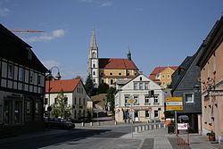 Main street with the Church of the Assumption of the Virgin Mary | ||
Location of Schirgiswalde-Kirschau within Bautzen district  | ||
(2018–25) Sven Gabriel[1] (FDP) | | |
| Area | ||
| • Total | 24.3 km2 (9.4 sq mi) | |
| Elevation | 250 m (820 ft) | |
| Population (2022-12-31)[2] | ||
| • Total | 6,057 | |
| • Density | 250/km2 (650/sq mi) | |
| Time zone | UTC+01:00 (CET) | |
| • Summer (DST) | UTC+02:00 (CEST) | |
| Postal codes | 02681 | |
| Dialling codes | 03592, 035938 | |
| Vehicle registration | BZ, BIW, HY, KM | |
| Website | https://www.stadt-schirgiswalde-kirschau.de/ | |
Schirgiswalde-Kirschau (Sorbian: Šěrachow-Korzym, pronounced [ˈʃɪʁaxɔf ˈkɔʁzɨm]) is a town in the district of Bautzen, in Saxony, Germany. It was formed on January 1, 2011 by the merger of the former municipalities Schirgiswalde, Kirschau and Crostau.[3]
References
- ^ Bürgermeisterwahlen 2018, Freistaat Sachsen, accessed 10 July 2021.
- ^ "Einwohnerzahlen nach Gemeinden als Excel-Arbeitsmappe" (XLS) (in German). Statistisches Landesamt des Freistaates Sachsen. 2024.
- ^ Gebietsänderungen vom 01. Januar bis 31. Dezember 2011, Statistisches Bundesamt
- v
- t
- e
Towns and municipalities in Bautzen (district)
- Arnsdorf
- Bautzen/Budyšin
- Bernsdorf
- Bischofswerda
- Burkau/Porchow
- Crostwitz/Chrósćicy
- Cunewalde
- Demitz-Thumitz
- Doberschau-Gaußig/Dobruša-Huska
- Elsterheide/Halštrowska Hola
- Elstra/Halštrow
- Frankenthal
- Göda/Hodźij
- Großdubrau/Wulka Dubrawa
- Großharthau
- Großnaundorf
- Großpostwitz/Budestecy
- Großröhrsdorf
- Haselbachtal
- Hochkirch/Bukecy
- Hoyerswerda/Wojerecy
- Kamenz/Kamjenc
- Königsbrück
- Königswartha/Rakecy
- Kubschütz/Kubšicy
- Laußnitz
- Lauta
- Lichtenberg
- Lohsa/Łaz
- Malschwitz/Malešecy
- Nebelschütz/Njebjelčicy
- Neschwitz/Njeswačidło
- Neukirch/Lausitz
- Neukirch (bei Königsbrück)
- Obergurig/Hornja Hórka
- Ohorn
- Oßling/Wóslink
- Ottendorf-Okrilla
- Panschwitz-Kuckau/Pančicy-Kukow
- Pulsnitz
- Puschwitz/Bóšicy
- Räckelwitz/Worklecy
- Radeberg
- Radibor/Radwor
- Ralbitz-Rosenthal/Ralbicy-Róžant
- Rammenau
- Schirgiswalde-Kirschau
- Schmölln-Putzkau
- Schwepnitz
- Sohland an der Spree
- Spreetal/Sprjewiny Doł
- Steina
- Steinigtwolmsdorf
- Wachau
- Weißenberg/Wóspork
- Wilthen
- Wittichenau/Kulow

Authority control databases | |
|---|---|
| International |
|
| National |
|
| Geographic |
|
 | This Bautzen location article is a stub. You can help Wikipedia by expanding it. |
- v
- t
- e


