School Street
Street in Boston, Massachusetts, United States
 School Street | |
| Location | Boston |
|---|---|
| West end | Tremont Street |
| East end | Washington Street |

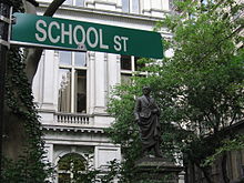
School Street is a short but significant street in the center of Boston, Massachusetts. It is so named for being the site of the first public school in the United States (the Boston Latin School, since relocated). The school operated at various addresses on the street from 1704 to 1844.
Effectively a southeastern extension of Beacon Street, School Street runs one or two blocks (it is bisected by Province Street on one side) from Tremont Street to Washington Street. Along the way, it passes King's Chapel, Boston's Old City Hall (on the first public school site), and the historic Old Corner Bookstore.
The Parker House hotel, 19th-century meeting place of politicians and literary figures as well as the origin point of several famous local dishes, is also located along the street.
The entirety of the street is part of the Freedom Trail, a red line that leads tourists to historic sites in the center of the city.
Timeline
17th–18th centuries
- 1635 – Gaol begins operating in vicinity.
- 1688 – King's Chapel built.
- 1708 – Officially named "School Street."[1]
- 1711 – October 2: Fire.
- 1716 – Governors' Province House in use near School Street.
- 1729
- South Meeting House built near School Street.
- Samuel Adams graduates from Latin School.
- 1748 – Latin Schoolhouse built.
- 1750 – John Hancock graduates from Latin School.
- 1754 – King's Chapel rebuilt in stone.
- 1772 – King's Chapel bell installed.
- 1798 – Massachusetts State House built at top of hill in vicinity of School Street.
19th century
- 1804 – Union Circulating Library in business.
- 1810 – County courthouse built.
- 1817 – Second Universalist Church consecrated.[2]
- 1827 – Tremont Theatre opens in vicinity of School Street.
- 1833 – Harding's Gallery of art active (approximate date).
- 1841
- City hall moves to School Street.
- Boston Museum opens near School Street.
- 1844 – Latin School moves away from School Street.[3]
- 1845 – Horticultural Hall built.
- 1854 – Ticknor and Fields publisher in business in the Corner Bookstore.
- 1855
- Parker House hotel in business.
- Saturday Club founded.[3]
- 1857 – Benjamin Franklin statue erected in front of city hall.
- 1858 – Boston Five Cents Savings Bank built.[3]
- 1865 – City hall rebuilt.
- 1868 – Charles Dickens stays at Parker House.[3]
- 1872 – November 9: Great Boston Fire occurs in vicinity, just missing School Street.
- 1885 – Hugh O'Brien becomes mayor.
20th century
- 1906 – John F. Fitzgerald becomes mayor.
- 1914 – James Michael Curley becomes mayor.
- 1920 – Charles Ponzi moved his fraud "Securities Exchange Company" to the Niles building on School Street.
- 1930 – Boston Public Library's Kirstein Business Branch opens off School Street.[4]
- 1958 – Freedom Trail stripe painted.[5]
- 1969 – City hall moves away from School Street.
- 1972 – Maison Robert restaurant in business.[6]
- 1973 – Boston Five Cents Savings Bank rebuilt.[7]
- 1982 – Globe Corner Bookstore in business.
See also
- Past tenants/activities
- Boston True Flag (c. 1852–1864)
- Richard Clarke (merchant) lived on School St., 18th century
- Mrs. Abner Haven's cafe, 19th century[8]
- Merry's Museum published on School St. in the 1840s
- Moses B. Russell, miniature painter, 19th century[9]
- Antoine Sonrel ran a photography studio, 1860s
- Watch and Ward Society, circa 1890s–1900s[10]
References
- ^ "School Street". A Record of the Streets, Alleys, Places, Etc. in the City of Boston. City of Boston. 1910. hdl:2027/bc.ark:/13960/t1kh1cs0r – via Hathi Trust.
- ^ Homans, Isaac Smith (1851). Sketches of Boston, past and present: And of some few places in its vicinity. Phillips, Sampson, and company. p. 93.
- ^ a b c d George A. Kyle (1926). The Eighteen Fifties: Being a Brief Account of School Street, the Province House and the Boston Five Cents Savings Bank. Eighteen fifties and the Boston Five Cents Savings Bank. Boston Five Cents Savings Bank.
- ^ "About Adams Street".
- ^ "The Freedom Trail Foundation - About the Foundation". Archived from the original on 2012-10-15.
- ^ "Archived copy". www.maisonrobert.com. Archived from the original on 18 February 1999. Retrieved 12 January 2022.
{{cite web}}: CS1 maint: archived copy as title (link) - ^ "Boston Five Cents Savings Bank, Boston by Kallmann McKinnell & Wood Architects".
- ^ Caroline Ticknor (1913), "Old Corner Bookstore", Hawthorne and his Publisher, Boston: Houghton Mifflin, OCLC 756324
- ^ Boston Almanac, 1841, 1847
- ^ Directory of the Charitable and Beneficent Organizations of Boston. Old Corner Bookstore. 1891.
External links
Wikimedia Commons has media related to School Street (Boston, Massachusetts).
- "Panoramic view of Boston City Hall, School Street, Boston, Mass". Library of Congress. 1903.
Further reading
- Henry F. Jenks (1895). "Old School Street". New England Magazine. 13. hdl:2027/inu.32000000704090 – via Hathi Trust.
Images
-
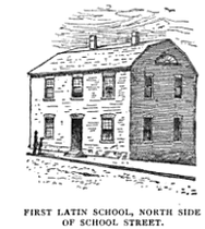 Boston Latin School, 17th century
 -
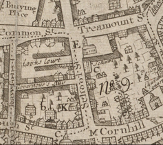 Detail of 1743 map of Boston by William Price, showing School Street and vicinity
 -
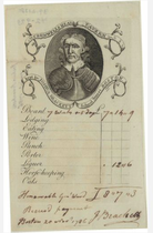 Bill from Cromwell's Head Tavern, 1768
 -
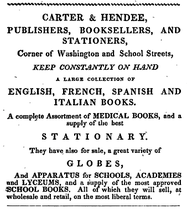 Ad for Carter & Hendee, booksellers; Washington St. and School St., Boston, 1832
 -
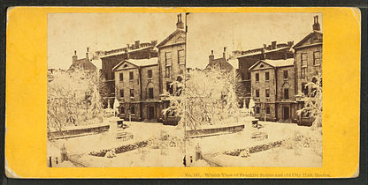 Winter view of Franklin statue and City Hall, 19th century, by John P. Soule
 -
 Harmoneons performing at Horticultural Hall, 1851
 -
 Railroad Jubilee, procession forming at City Hall, 1854 (from Gleason's Pictorial)
 -
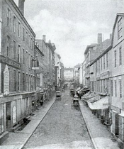 School St., 1858
 -
 Parker House, 19th century
 -
 Intersection of Washington St. and School St., 19th century
 -
 Corner of School and Tremont Streets, 1900


42°21′27.5″N 71°3′34.84″W / 42.357639°N 71.0596778°W / 42.357639; -71.0596778
- v
- t
- e
Streets and squares in Boston
- Beacon Street
- Boylston Street
- Commonwealth Avenue
- Congress Street
- Court Street
- Day Boulevard
- Dedham Parkway
- Fenway
- Gallivan Boulevard
- Huntington Avenue
- Melnea Cass Boulevard
- Milk Street
- Neptune Road
- New Chardon Street
- Newbury Street
- Park Street
- Soldiers Field Road
- State Street
- Storrow Drive
- Summer Street
- Tremont Street
- Winter Street

- Arborway
- Atlantic Avenue
- Blue Hills Parkway
- Bowdoin Street
- Brattle Street
- Brookline Avenue
- Charles Street
- Columbus Avenue
- Dorchester Avenue
- Enneking Parkway
- Federal Street
- Franklin Street
- Hanover Street
- Jamaicaway
- Jersey Street (Yawkey Way)
- Massachusetts Avenue
- Morrissey Boulevard
- Morton Street
- North Street
- Park Drive
- Riverway
- School Street
- Truman Parkway
- Turtle Pond Parkway
- Union Street
- Veterans of Foreign Wars Parkway
- Washington Street
- West Boundary Road
- West Roxbury Parkway
- Adams Square
- Andrew Square
- Blackstone Square
- Brigham Circle
- Central Square
- Chester Square
- City Square
- Cleveland Circle
- Codman Square
- Copley Square
- Day Square
- Dewey Square
- Dock Square
- Downtown Crossing
- Egleston Square
- Fields Corner
- Franklin Square
- Haymarket Square
- Hyde Square
- Jackson Square
- Kenmore Square
- Louisburg Square
- Mass and Cass
- Maverick Square
- Nubian Square (Dudley Square)
- Packard's Corner
- Park Square
- Peabody Square
- Post Office Square
- Roxbury Crossing
- Scollay Square
- Sullivan Square
- Thompson Square
- Union Square
- Uphams Corner
- Winthrop Square
- Italics denote streets and squares that no longer exist.
| Authority control databases: National |
|
|---|


