Slaugham
Human settlement in England
- Slaugham
- Mid Sussex
- West Sussex
- South East
01293
- Horsham
- List of places
- UK
- England
- West Sussex
Slaugham (/ˈslɑːfəm/)[3] is a village and civil parish in the Mid Sussex District of West Sussex, England. It is located 7 miles (11 km) to the south of Crawley, on the A23 road to Brighton. The civil parish covers an area of 2,432 hectares (6,010 acres). At the 2001 census it had a population of 2,226 persons of whom 1,174 were economically active. At the 2011 Census the parish included the villages of Handcross and Warninglid and had a population of 2,769.[2] In addition the parish contains the settlement of Pease Pottage.
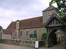
St Mary's Church is a Grade II* listed building dating mostly from the 12th and 13th centuries and is situated opposite Slaugham's village green. It serves all four villages.[4][5] Church Covert wood off Staplefied Road is managed by the Woodland Trust.[6]
References
- ^ a b "2001 Census: West Sussex – Population by Parish" (PDF). West Sussex County Council. Archived from the original (PDF) on 8 June 2011. Retrieved 10 April 2009.
- ^ a b "Civil Parish population 2011". Neighbourhood Statistics. Office for National Statistics. Retrieved 29 September 2016.
- ^ Swinfen & Arscott 1984, p. 124.
- ^ Salzman, L. F., ed. (1940). "A History of the County of Sussex: Volume 7 – The Rape of Lewes. Parishes: Slaugham". Victoria County History of Sussex. British History Online. pp. 181–186. Retrieved 25 March 2010.
- ^ Historic England (2007). "The Parish of St Mary, The Green (south side), Slaugham, Mid Sussex, West Sussex (1025603)". National Heritage List for England. Retrieved 25 March 2010.
- ^ "Church Covert, Slaugham". Woodland Trust. Retrieved 13 August 2020.
Bibliography
- Swinfen, Warden; Arscott, David (1984). Hidden Sussex. Brighton: BBC Radio Sussex. ISBN 0-9509510-0-5.
External links
- St Mary's Church
![]() Media related to Slaugham at Wikimedia Commons
Media related to Slaugham at Wikimedia Commons
- v
- t
- e
Settlements in the Mid Sussex district of West Sussex
- Albourne
- Ansty
- Ardingly
- Ashurst Wood
- Balcombe
- Bolney
- Clayton
- Copthorne
- Crawley Down
- Cuckfield
- Fulking
- Goddards Green
- Handcross
- Hassocks
- Hickstead
- Horsted Keynes
- Hurst Wickham
- Hurstpierpoint
- Keymer
- Lindfield
- Newtimber
- Pease Pottage
- Poynings
- Pyecombe
- Saddlescombe
- Saint Hill Green
- Sayers Common
- Scaynes Hill
- Sharpthorne
- Slaugham
- Staplefield
- Turners Hill
- Twineham
- Walstead
- Warninglid
- West Hoathly
Authority control databases | |
|---|---|
| International |
|
| National |
|
 | This West Sussex location article is a stub. You can help Wikipedia by expanding it. |
- v
- t
- e


