Sousel
Municipality in Alentejo, Portugal

Flag

Coat of arms

 Portugal
 (2011)
date varies
Sousel (Portuguese pronunciation: [soˈzɛl] ⓘ) is a municipality in the District of Portalegre in Portugal. The population in 2011 was 5,074,[1] in an area of 279.32 km2.[2]
The municipality is famous for its olive trees and as a great hunting region.
The Calça e Pina family was the main developer of Sousel in the 18th century. The economy is mainly based on agriculture, but tourism plays a major role in the region's economy as well.
The present Mayor is Manuel Valério, elected by the Socialist Party. The municipal holiday is Easter Monday.
Parishes
Administratively, the municipality is divided into 4 civil parishes (freguesias):[3]
- Cano
- Casa Branca
- Santo Amaro
- Sousel
Notable people
- Bruno Bolas (born 1996) a Portuguese professional footballer
Gallery
-
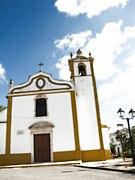 Local church.
 -
 Distinctive Alentejano chimney.


References
- ^ Instituto Nacional de Estatística
- ^ Áreas das freguesias, concelhos, distritos e país
- ^ Diário da República. "Law nr. 11-A/2013, page 552 117" (pdf) (in Portuguese). Retrieved 31 July 2014.
External links
- Town Hall official website
Authority control databases | |
|---|---|
| International |
|
| National |
|
 | This Portalegre location article is a stub. You can help Wikipedia by expanding it. |
- v
- t
- e


