Tajná
Municipality in Slovakia
48°16′N 18°22′E / 48.267°N 18.367°E / 48.267; 18.367 Slovakia
 (2021)
952 01[3]
Tajná (Hungarian: Tajnasári) is a village and municipality in the Nitra District in western central Slovakia, in the Nitra Region.[5]
History
In historical records the village was first mentioned in 1075.
Geography
The village lies at an altitude of 174 metres and covers an area of 8.482 km2. It has a population of about 288 people.
Ethnicity
The population is about 98% Slovak and 2% Magyar.
Gallery
-
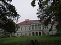 Révay's manor house

References
- ^ "Počet obyvateľov podľa pohlavia - obce (ročne)". www.statistics.sk (in Slovak). Statistical Office of the Slovak Republic. 2022-03-31. Archived from the original on 2021-03-22. Retrieved 2022-03-31.
- ^ a b "Hustota obyvateľstva - obce [om7014rr_ukaz: Rozloha (Štvorcový meter)]". www.statistics.sk (in Slovak). Statistical Office of the Slovak Republic. 2022-03-31. Archived from the original on 2021-03-22. Retrieved 2022-03-31.
- ^ a b c d "Základná charakteristika". www.statistics.sk (in Slovak). Statistical Office of the Slovak Republic. 2015-04-17. Archived from the original on 2021-03-22. Retrieved 2022-03-31.
- ^ a b "Hustota obyvateľstva - obce". www.statistics.sk (in Slovak). Statistical Office of the Slovak Republic. 2022-03-31. Archived from the original on 2021-03-22. Retrieved 2022-03-31.
- ^ "Tajná - Okres Nitra - E-OBCE.sk". Archived from the original on 2016-03-24. Retrieved 2012-08-04.
External links
 Media related to Tajná, Nitra District at Wikimedia Commons
- Official website

- http://www.statistics.sk/mosmis/eng/run.html
- v
- t
- e
Municipalities of Nitra District
- Alekšince
- Báb
- Babindol
- Bádice
- Branč
- Cabaj-Čápor
- Čab
- Čakajovce
- Čechynce
- Čeľadice
- Čifáre
- Dolné Lefantovce
- Dolné Obdokovce
- Golianovo
- Horné Lefantovce
- Hosťová
- Hruboňovo
- Ivanka pri Nitre
- Jarok
- Jelenec
- Jelšovce
- Kapince
- Klasov
- Kolíňany
- Lehota
- Lúčnica nad Žitavou
- Lukáčovce
- Lužianky
- Ľudovítová
- Malé Chyndice
- Malé Zálužie
- Malý Cetín
- Malý Lapáš
- Melek
- Mojmírovce
- Nitrianske Hrnčiarovce
- Nová Ves nad Žitavou
- Nové Sady
- Paňa
- Podhorany
- Pohranice
- Poľný Kesov
- Rišňovce
- Rumanová
- Svätoplukovo
- Štefanovičová
- Štitáre
- Šurianky
- Tajná
- Telince
- Veľká Dolina
- Veľké Chyndice
- Veľké Zálužie
- Veľký Cetín
- Veľký Lapáš
- Vinodol
- Výčapy-Opatovce
- Zbehy
- Žirany
- Žitavce

Authority control databases | |
|---|---|
| International |
|
| National |
|
 | This Nitra Region geography article is a stub. You can help Wikipedia by expanding it. |
- v
- t
- e


