Tamazula de Victoria
City in the Mexican state of Durango
Municipal seat and city in Durango, Mexico
Seal
24°58′12″N 106°57′56″W / 24.97000°N 106.96556°W / 24.97000; -106.96556
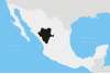
 Mexico
 (2010)
34580
Tamazula de Victoria is a small town and seat of the municipality of Tamazula in the Mexican state of Durango. The town is located approximately 53 mi (85 km) east of the city center of Culiacán, Sinaloa, in the Sierra Madre Occidental mountains. The Tamazula River crescents directly north of the city.
Colloquially known as Tamazula, its official name is Tamazula de Victoria after the first president of Mexico's adopted last name was added. General Guadalupe Victoria, the first president of Mexico, and his brother Francisco Victoria were born in Tamazula. As of 2010, the town had a population of 2,337[1]
History
In the seventeenth century, Jesuit missionaries founded Mission San Ignacio de Tamazula.[2]
Villages
The municipal subdivisions of Tamazula are:
- Amaculi
- Los Remedios
- El Chicural
- El Cocoyole
- Chacala
- El Llano
- El Comedero
- Las Juntas
- Las Quebradas
- El Río
- Pueblo Viejo
- El Carrizo
- Otatitlán
- Las Coloradas
- Santa Elena
- El Cajón
- La Mesa del Rodeo
- El Durazno
- La Alameda
- Santa Gertrudis
- El Tecuán
- Santa Barbara
- Cuesta Blanca
Gallery
-
 Cactus Cardon Guajiro and Corn at Sunset after a summer thunderstorm in Tamazula, Durango
 -
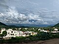 Hillside view looking East
 -
 Templo San Ignacio de Layola Catholic Church
 -
 Interior view of San Ignacio de Layola Catholic Church altar in 2013
 -
 1786 Birthplace and childhood home of Guadalupe Victoria. Now a museum


References
- ^ "Tamazula". Catálogo de Localidades. Secretaría de Desarrollo Social (SEDESOL). Retrieved 23 April 2014.
- ^ Deeds, Susan M. (1 August 2003). Defiance and Deference in Mexico's Colonial North: Indians Under Spanish Rule in Nueva Vizcaya. University of Texas Press. pp. 57–58, 161. ISBN 978-0-292-70551-7.
24°58′12″N 106°57′56″W / 24.97000°N 106.96556°W / 24.97000; -106.96556
- v
- t
- e
 State of Durango
Durango (capital)
and
(municipal seats)
- Canatlán (Ciudad Canatlán)
- Canelas (Canelas)
- Coneto de Comfort (Coneto de Comonfort)
- Cuencamé (Cuencamé)
- Durango (Victoria de Durango)
- El Oro (Santa María del Oro)
- General Simón Bolívar (General Simón Bolívar)
- Gómez Palacio (Gómez Palacio)
- Guadalupe Victoria (Ciudad Guadalupe Victoria)
- Guanaceví (Guanaceví)
- Hidalgo (Villa Hidalgo)
- Indé (Indé)
- Lerdo (Ciudad Lerdo)
- Mapimí (Mapimí)
- Mezquital (San Francisco del Mezquital)
- Nazas (Nazas)
- Nombre de Dios (Nombre de Dios)
- Nuevo Ideal (Nuevo Ideal)
- Ocampo (Villa Ocampo)
- Otáez (Otáez)
- Pánuco de Coronado (Francisco I. Madero)
- Peñón Blanco (Peñón Blanco)
- Poanas (Villa Unión)
- Pueblo Nuevo (El Salto)
- Rodeo (Rodeo)
- San Bernardo (San Bernardo)
- San Dimas (Tayoltita)
- San Juan de Guadalupe (San Juan de Guadalupe)
- San Juan del Río (San Juan del Río)
- San Luis del Cordero (San Luis del Cordero)
- San Pedro del Gallo (San Pedro del Gallo)
- Santa Clara (Santa Clara)
- Santiago Papasquiaro (Santiago Papasquiaro)
- Súchil (Súchil)
- Tamazula (Tamazula de Victoria)
- Tepehuanes (Santa Catarina de Tepehuanes)
- Tlahualilo (Tlahualilo de Zaragoza)
- Topia (Topia)
- Vicente Guerrero (Vicente Guerrero)