Ullastret
Municipality in Catalonia, Spain

Flag

Coat of arms
42°00′02″N 3°04′07″E / 42.000548°N 3.068483°E / 42.000548; 3.068483
 Spain
Spain Catalonia
 (2018)[3]
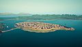
Ullastret is a small historic village on the Bay of Empordà located some 5 km northeast of La Bisbal d'Empordà, in Catalonia.
In prehistoric times the village was probably on an island in the former 3 km2 lake, known as Llac d'Ullastret or Estany d'Ullastret, connected by a causway, but the lake dried up in the 19th century.[4]
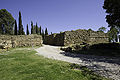
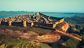
It is home to ancient Iberian archaeological remains, in particular much of the thick walls around the village are ancient. There is a medieval church known from the 9th century, dedicated to SS. Paul and Peter. The economy is based mostly on tourism and agriculture.
Gallery
-
 Inscribed lead plate from the Ullastret Iberian archaeological site
 -
 Cistern at the Ullastret site
 -
 Terracota masks
 -
 Walls
Walls -
 Walls
Walls -
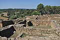 Building remains
 -
 Building remains
 -
 Digital reconstruction of Iberian Ullastret
 -
 Digital reconstruction
 -
 Digital reconstruction


See also
- Indigetes
References
- ^ "Ajuntament d'Ullastret". Generalitat of Catalonia. Retrieved 2015-11-13.
- ^ "El municipi en xifres: Ullastret". Statistical Institute of Catalonia. Retrieved 2015-11-23.
- ^ Municipal Register of Spain 2018. National Statistics Institute.
- ^ Ullastret - Poblat Ibèric l'Illa d'en Reixac
External links
- Government data pages (in Catalan)
Places adjacent to Ullastret | ||||||||||||||||
|---|---|---|---|---|---|---|---|---|---|---|---|---|---|---|---|---|
| ||||||||||||||||


- v
- t
- e
- Albons
- Begur
- Bellcaire d'Empordà
- Bisbal d'Empordà
- Calonge
- Castell-Platja d'Aro
- Colomers
- Corçà
- Cruïlles, Monells i Sant Sadurní de l'Heura
- Foixà
- Fontanilles
- Forallac
- Garrigoles
- Gualta
- Jafre
- Mont-ras
- Palafrugell
- Palamós
- Palau-sator
- Pals
- Parlavà
- Pera
- Regencós
- Rupià
- Sant Feliu de Guíxols
- Santa Cristina d'Aro
- Serra de Daró
- Tallada d'Empordà
- Torrent
- Torroella de Montgrí
- Ullastret
- Ullà
- Ultramort
- Vall-llobrega
- Verges
- Vilopriu

- Aiguablava
- Aiguafreda [ca]
- Agua Xelida [ca]
- Aigüeta [ca]
- Albons
- Anyells [ca]
- Barceloneta [ca]
- Bateries [ca]
- Begur
- Bellcaire d'Empordà
- Bell-lloc [ca]
- Bisbal d'Empordà
- Bruguerol [ca]
- Cala s´Alguer
- Calella de Palafrugell
- Calonge
- Canyet de Mar [ca]
- Casavells [ca]
- Cassà de Pelràs [ca]
- Castell d'Aro
- Castell d'Empordà [ca]
- Colomers
- Corçà
- Cruïlles
- Ermedàs [ca]
- Esclanyà [ca]
- Estartit
- Foixà
- Fontanilles
- Forallac
- Fornells de Mar
- Fosca
- Garrigoles
- Gaüses [ca]
- Gualta
- Jafre
- Llafranc
- Llofriu
- Matajudaica [ca]
- Monells
- Mont-ras
- Palafrugell
- Palamós
- Palau-sator
- Pals
- Parlavà
- Barri del Pedró (Pals) [ca]
- Pera
- Peratallada
- Pins [ca]
- Planils [ca]
- Platja d'Aro
- Port Bo [ca]
- Púbol
- Regencós
- Romanyà de la Selva [ca]
- Rupià
- S'Agaró
- Sa Riera
- Sa Tuna [ca]
- Sant Amanç [ca]
- Sant Antoni de Calonge
- Sant Feliu de Guíxols
- Sant Joan de Palamós [ca]
- Sant Pol (la Bisbal d'Empordà) [ca]
- Sant Pol (Sant Feliu de Guíxols) [ca]
- Sant Sadurní de l'Heura [ca]
- Santa Cristina d'Aro
- Santa Margarida [ca]
- Sauleda [ca]
- Serra de Daró
- Solius [ca]
- Tallada d'Empordà
- Tamariu
- Torrent
- Torroella de Montgrí
- Ullastret
- Ullà
- Ultramort
- Valldevià [ca]
- Vall-llobrega
- Verges
- Vilar d'Aro [ca]
- Vilartagues [ca]
- Vilopriu
Authority control databases | |
|---|---|
| International |
|
| National |
|
| Other |
|
 | This Province of Girona location article is a stub. You can help Wikipedia by expanding it. |
- v
- t
- e


