Vammala
You can help expand this article with text translated from the corresponding article in Finnish. (June 2023) Click [show] for important translation instructions.
- Machine translation, like DeepL or Google Translate, is a useful starting point for translations, but translators must revise errors as necessary and confirm that the translation is accurate, rather than simply copy-pasting machine-translated text into the English Wikipedia.
- Do not translate text that appears unreliable or low-quality. If possible, verify the text with references provided in the foreign-language article.
- You must provide copyright attribution in the edit summary accompanying your translation by providing an interlanguage link to the source of your translation. A model attribution edit summary is
Content in this edit is translated from the existing Finnish Wikipedia article at [[:fi:Vammala]]; see its history for attribution. - You may also add the template
{{Translated|fi|Vammala}}to the talk page. - For more guidance, see Wikipedia:Translation.
Former town and municipality in Pirkanmaa, Finland

Coat of arms
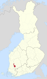
Location of Vammala in Finland
(2008-12-31)[2]
Vammala is a former town and municipality of southwestern Finland, chartered in 1907. On 1 January 2009, Vammala was consolidated with the municipalities of Mouhijärvi and Äetsä, to form a new city named Sastamala.
Geography
Vammala was located in the southwest Pirkanmaa region, and was part of the former (1997 to 2010) province of Western Finland.
- Demographics
The municipality had a population of 16,635 (31 December 2008)[2] and covered a land area of 803.87 square kilometres (310.38 sq mi).[1] The population density was 20.29 inhabitants per square kilometre (52.6/sq mi).
The municipality was unilingually Finnish.

See also
References
- ^ a b "Area by municipality as of 1 January 2008" (PDF) (in Finnish and Swedish). Land Survey of Finland. Archived from the original (PDF) on 2011-08-07. Retrieved 13 April 2010.
- ^ a b "Population by municipality as of 31 December 2008". Population Information System (in Finnish and Swedish). Population Register Center of Finland. Archived from the original on 2010-12-02. Retrieved 13 April 2010.
External links
Wikimedia Commons has media related to Vammala.
- Official Vammala website
- v
- t
- e

- Äetsä
- Aitolahti
- Akaa [fi]
- Eräjärvi
- Ikaalisten maalaiskunta [fi]
- Karkku
- Keikyä
- Kiikka
- Kuhmalahti
- Kuorevesi
- Kuru
- Kylmäkoski
- Längelmäki
- Luopioinen
- Mänttä
- Messukylä
- Mouhijärvi
- Pohjaslahti
- Sääksmäki
- Sahalahti
- Suodenniemi
- Suoniemi
- Teisko
- Toijala
- Tottijärvi
- Tyrväntö (part)
- Tyrvää
- Vammala
- Viiala
- Viljakkala
- Vilppula
Authority control databases | |
|---|---|
| International |
|
| National |
|
 | This Western Finland location article is a stub. You can help Wikipedia by expanding it. |
- v
- t
- e


