District d'Eisenstadt-Umgebung
| Eisenstadt-Umgebung | |||
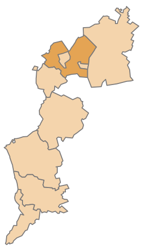 Localisation du district d'Eisenstadt-Umgebung dans le Land autrichien de Burgenland. | |||
| Administration | |||
|---|---|---|---|
| Pays |  Autriche Autriche | ||
| Land |  Burgenland Burgenland | ||
| Centre administratif | Eisenstadt | ||
| Immatriculation | EU | ||
| Démographie | |||
| Population | 42 066 hab. ([1]) | ||
| Densité | 93 hab./km2 | ||
| Géographie | |||
| Coordonnées | 47° 50′ 17″ nord, 16° 32′ 24″ est | ||
| Superficie | 45 267 ha = 452,67 km2 | ||
| Localisation | |||
| Géolocalisation sur la carte : Autriche
Géolocalisation sur la carte : Autriche
| |||
modifier  | |||


Le district d'Eisenstadt-Umgebung (« Eisenstadt-campagne ») est un district (Bezirk) du Land autrichien de Burgenland.
Municipalités
Le district d'Eisenstadt-Umgebung est constitué des municipalités suivantes :
- Breitenbrunn am Neusiedler See
- Donnerskirchen
- Großhöflein
- Hornstein
- Klingenbach
- Leithaprodersdorf
- Loretto
- Mörbisch am See
- Müllendorf
- Neufeld an der Leitha
- Oggau am Neusiedler See
- Oslip
- Purbach am Neusiedlersee
- Sankt Margarethen im Burgenland
- Schützen am Gebirge
- Siegendorf
- Steinbrunn
- Stotzing
- Trausdorf an der Wulka
- Wimpassing an der Leitha
- Wulkaprodersdorf
- Zagersdorf
- Zillingtal
Carte interactive des communes du district d'Eisenstadt-Umgebung

Les subdivisions administratives.
Notes et références
- ↑ « http://www.statistik.at/wcm/idc/idcplg?IdcService=GET_NATIVE_FILE&RevisionSelectionMethod=LatestReleased&dDocName=080904 » (consulté le )
- ↑ a b c d e f g h i j k l et m Statistik Austria (en), « Bevölkerung am 1.1.2021 nach Ortschaften (Gebietsstand 1.1.2021) »
- ↑ a b c d e f g h et i « Einwohnerzahl 1.1.2018 nach Gemeinden mit Status, Gebietsstand 1.1.2018 », Statistik Austria (en) (consulté le )
v · m | ||
|---|---|---|
| Les 7 districts (Bezirke) et les 2 villes à statut (Statutarstädte) du Burgenland, en Autriche | ||
| Villes à statut |
|  |
| Districts |
| |
v · m Communes dans le district d'Eisenstadt-Umgebung | ||
|---|---|---|
|  | |
 Portail de l'Autriche


