High Peak
Niet-metropolitaans district in Engeland  | |||
|---|---|---|---|
 | |||
| Situering | |||
| Land | Engeland | ||
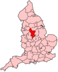
| County | Derbyshire | ||
| Regio | East Midlands | ||
| Coördinaten | 53°21'NB, 1°51'WL | ||
| Algemeen | |||
| Oppervlakte | 539,1433[1] km² | ||
| Inwoners (2018[2]) | 92221 (171 inw./km²) | ||
| Hoofdplaats ONS-code | Chapel-en-le-Frith E07000037 | ||
| Detailkaart | |||
[[Bestand: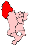 |266px|class=notpageimage|alt=Kaart van High Peak]] |266px|class=notpageimage|alt=Kaart van High Peak]] | |||
| |||

High Peak is een Engels district in het shire-graafschap (non-metropolitan county OF county) Derbyshire en telt 92.000 inwoners. De oppervlakte bedraagt 539 km². Hoofdplaats is Chapel-en-le-Frith.
Van de bevolking is 15,4% ouder dan 65 jaar. De werkloosheid bedraagt 2,7% van de beroepsbevolking (cijfers volkstelling 2001).
Het district omvat een groot deel van het Nationaal park Peak District.
Plaatsen in district High Peak
Buxton, Glossop.
Civil parishes in district High Peak
Aston, Bamford, Brough and Shatton, Castleton, Chapel-en-le-Frith, Charlesworth, Chinley, Buxworth and Brownside, Chisworth, Derwent, Edale, Green Fairfield, Hartington upper Quarter, Hayfield, Hope, Hope Woodlands, King Sterndale, New Mills, Peak Forest, Thornhill, Tintwistle, Whaley Bridge, Wormhill.
Bronnen, noten en/of referenties
|
Indeling van het graafschap Derbyshire
Unitary authority: Derby
Districten: Amber Valley · Bolsover · Chesterfield · Derbyshire Dales · Erewash · High Peak · North East Derbyshire · South Derbyshire
Lijst van plaatsen in het graafschap Derbyshire
Civil parishes in het ceremoniële graafschap Derbyshire:
Abney and Abney Grange · Aldercar and Langley Mill · Alderwasley · Aldwark · Alfreton · Alkmonton · Ash · Ashbourne · Ashford in the Water · Ashleyhay · Ashover · Aston-on-Trent · Aston · Atlow · Ault Hucknall · Bakewell · Ballidon · Bamford · Barlborough · Barlow · Barrow upon Trent · Barton Blount · Baslow and Bubnell · Bearwardcote · Beeley · Belper · Biggin by Hulland · Birchover · Blackwell · Blackwell in the Peak · Bonsall · Boylestone · Brackenfield · Bradbourne · Bradley · Bradwell · Brailsford · Brampton · Brassington · Breadsall · Breaston · Bretby · Brimington · Brough and Shatton · Brushfield · Burnaston · Calke · Callow · Calow · Calver · Carsington · Castle Gresley · Castleton · Catton · Cauldwell · Chapel-en-le-Frith · Charlesworth · Chatsworth · Chelmorton · Chinley, Buxworth and Brownside · Chisworth · Church Broughton · Clay Cross · Clifton and Compton · Clowne · Codnor · Coton in the Elms · Crich · Cromford · Cubley · Curbar · Dalbury Lees · Dale Abbey · Darley Dale · Denby · Derwent · Dethick, Lea and Holloway · Doveridge · Drakelow · Draycott and Church Wilne · Dronfield · Duffield · Eaton and Alsop · Eckington · Edale · Edensor · Edlaston and Wyaston · Egginton · Elmton with Creswell · Elton · Elvaston · Etwall · Eyam · Fenny Bentley · Findern · Flagg · Foolow · Foremark · Foston and Scropton · Froggatt · Glapwell · Grassmoor, Hasland and Winswick · Gratton · Great Hucklow · Great Longstone · Green Fairfield · Grindleford · Grindlow · Harthill · Hartington Middle Quarter · Hartington Nether Quarter · Hartington Town Quarter · Hartington Upper Quarter · Hartshorne · Hassop · Hathersage · Hatton · Hayfield · Hazelwood · Hazlebadge · Heanor and Loscoe · Heath and Holmewood · Highlow · Hilton · Hognaston · Holbrook · Hollington · Holmesfield · Holymoorside and Walton · Hoon · Hope · Hope Woodlands · Hopton · Hopwell · Horsley · Horsley Woodhouse · Hulland · Hulland Ward · Hungry Bentley · Ible · Idridgehay and Alton · Ingleby · Ironville · Ivonbrook Grange · Kedleston · Kilburn · Killamarsh · King Sterndale · Kirk Ireton · Kirk Langley · Kniveton · Lea Hall · Linton · Little Eaton · Little Hucklow · Little Longstone · Litton · Longford · Lullington · Mackworth · Mapleton · Mapperley · Marston Montgomery · Marston on Dove · Matlock Bath · Matlock Town · Melbourne · Mercaston · Middleton · Middleton and Smerrill · Monyash · Morley · Morton · Nether Haddon · Netherseal · New Mills · Newton Grange · Newton Solney · Norbury and Roston · North Wingfield · Northwood and Tinkersley · Ockbrook and Borrowash · Offcote and Underwood · Offerton · Old Bolsover · Osleston and Thurvaston · Osmaston · Outseats · Over Haddon · Overseal · Parwich · Peak Forest · Pentrich · Pilsley · Pilsley · Pinxton · Pleasley · Quarndon · Radbourne · Ravensdale Park · Repton · Ripley · Risley · Rodsley · Rosliston · Rowland · Rowsley · Sandiacre · Sawley · Scarcliffe · Shardlow and Great Wilne · Sheldon · Shipley · Shirebrook · Shirland and Higham · Shirley · Shottle and Postern · Smalley · Smisby · Snelston · Somercotes · Somersal Herbert · South Darley · South Normanton · South Wingfield · Stanley and Stanley Common · Stanton · Stanton by Bridge · Stanton By Dale · Staveley · Stenson Fields · Stoney Middleton · Stretton · Sudbury · Sutton-cum-Duckmanton · Sutton on the Hill · Swanwick · Swarkestone · Taddington · Tansley · Temple Normanton · Thornhill · Thorpe · Tibshelf · Ticknall · Tideswell · Tintwistle · Tissington · Trusley · Tupton · Turnditch · Twyford and Stenson · Unstone · Walton-upon-Trent · Wardlow · Wessington · West Hallam · Weston-on-Trent · Weston Underwood · Whaley Bridge · Wheston · Whitwell · Willington · Windley · Wingerworth · Winster · Wirksworth · Woodville · Wormhill · Yeaveley · Yeldersley · Youlgreave


