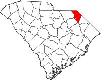
Marlboro County
County in de Verenigde Staten  | |||
|---|---|---|---|
 | |||
| Situering | |||
| Staat | South Carolina | ||
| Coördinaten | 34°36'0"NB, 79°40'48"WL | ||
| Algemeen | |||
| Oppervlakte | 1.256 km² | ||
| - land | 1.242 km² | ||
| - water | 14 km² | ||
| Inwoners (2000) | 28.818 (23 inw./km²) | ||
| Overig | |||
| Zetel | Bennettsville | ||
| FIPS-code | 45069 | ||
| Opgericht | 1798 | ||
| Foto's | |||
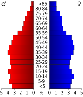 Bevolkingspiramide Marlboro County | |||
| Statistieken volkstelling Marlboro County | |||
| |||

Marlboro County is een van de 46 county's in de Amerikaanse staat South Carolina.
De county heeft een landoppervlakte van 1.242 km² en telt 28.818 inwoners (volkstelling 2000). De hoofdplaats is Bennettsville.
Bevolkingsontwikkeling
| Jaar | Inwoners | % ± | |
|---|---|---|---|
| 1900 | 27.639 | — | |
| 1910 | 31.189 | 12,8% | |
| 1920 | 33.180 | 6,4% | |
| 1930 | 31.634 | −4,7% | |
| 1940 | 33.281 | 5,2% | |
| 1950 | 31.766 | −4,6% | |
| 1960 | 28.529 | −10,2% | |
| 1970 | 27.151 | −4,8% | |
| 1980 | 31.634 | 16,5% | |
| 1990 | 29.361 | −7,2% | |
| 2000 | 28.818 | −1,8% | |
| Bron: (en) Historical Decennial Census Population | |||

· Abbeville County · Aiken County · Allendale County · Anderson County · Bamberg County · Barnwell County · Beaufort County · Berkeley County · Calhoun County · Charleston County · Cherokee County · Chester County · Chesterfield County · Clarendon County · Colleton County · Darlington County · Dillon County · Dorchester County · Edgefield County · Fairfield County · Florence County · Georgetown County · Greenville County · Greenwood County · Hampton County · Horry County · Jasper County · Kershaw County · Lancaster County · Laurens County · Lee County · Lexington County · Marion County · Marlboro County · McCormick County · Newberry County · Oconee County · Orangeburg County · Pickens County · Richland County · Saluda County · Spartanburg County · Sumter County · Union County · Williamsburg County · York County


