McLean County (North Dakota)
County in de Verenigde Staten  | |||
|---|---|---|---|
 | |||
| Situering | |||
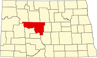
| Staat | North Dakota | ||
| Tijdzone | Central Standard Time (UTC−6) | ||
| Coördinaten | 47°36'36"NB, 101°19'12"WL | ||
| Algemeen | |||
| Oppervlakte | 6.030 km² | ||
| - land | 5.465 km² | ||
| - water | 565 km² | ||
| Inwoners (2000) | 9.311 (2 inw./km²) | ||
| Overig | |||
| Zetel | Washburn | ||
| FIPS-code | 38055 | ||
| Opgericht | 1883 | ||
| Foto's | |||
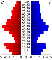 Bevolkingspiramide McLean County | |||
| Statistieken volkstelling McLean County | |||
| |||

McLean County is een county in de Amerikaanse staat North Dakota.
De county heeft een landoppervlakte van 5.465 km² en telt 9.311 inwoners (volkstelling 2000). De hoofdplaats is Washburn.
Adams County · Barnes County · Benson County · Billings County · Bottineau County · Bowman County · Burke County · Burleigh County · Cass County · Cavalier County · Dickey County · Divide County · Dunn County · Eddy County · Emmons County · Foster County · Golden Valley County · Grand Forks County · Grant County · Griggs County · Hettinger County · Kidder County · La Moure County · Logan County · McHenry County · McIntosh County · McKenzie County · McLean County · Mercer County · Morton County · Mountrail County · Nelson County · Oliver County · Pembina County · Pierce County · Ramsey County · Ransom County · Renville County · Richland County · Rolette County · Sargent County · Sheridan County · Sioux County · Slope County · Stark County · Steele County · Stutsman County · Towner County · Traill County · Walsh County · Ward County · Wells County · Williams County


