Grade II* listed buildings in Tendring
Map all coordinates using OpenStreetMap
Download coordinates as:
- KML
- GPX (all coordinates)
- GPX (primary coordinates)
- GPX (secondary coordinates)
There are over 20,000 Grade II* listed buildings in England. This page is a list of these buildings in the district of Tendring in Essex.
Tendring
| Name | Location | Type | Completed [note 1] | Date designated | Grid ref.[note 2] Geo-coordinates | Entry number [note 3] | Image |
|---|---|---|---|---|---|---|---|
| The Quarters | Alresford Park, Alresford, Tendring | House | c. 1951 | 21 February 1950 | TM0721520124 51°50′29″N 1°00′24″E / 51.841254°N 1.006608°E / 51.841254; 1.006608 (The Quarters) | 1337178 |  Upload Photo |
| Church of St Mary | Ardleigh, Tendring | Parish Church | 14th century | 17 November 1966 | TM0539129550 51°55′36″N 0°59′09″E / 51.92656°N 0.985775°E / 51.92656; 0.985775 (Church of St Mary) | 1112060 |  More images |
| Spring Valley Mill | Ardleigh, Tendring | Mill | Late 18th century | 17 November 1966 | TM0383027745 51°54′39″N 0°57′43″E / 51.910927°N 0.962038°E / 51.910927; 0.962038 (Spring Valley Mill) | 1112053 |  More images |
| Beaumont Hall | Beaumont-cum-Moze, Tendring | House | Late 17th century | 29 April 1952 | TM1796924590 51°52′38″N 1°09′55″E / 51.877256°N 1.165281°E / 51.877256; 1.165281 (Beaumont Hall) | 1322628 |  More images |
| Beaumont Rectory | Beaumont-cum-Moze, Tendring | House | c. 1800 | 29 April 1952 | TM1777324977 51°52′51″N 1°09′46″E / 51.880806°N 1.162682°E / 51.880806; 1.162682 (Beaumont Rectory) | 1112125 | Upload Photo |
| Elmstead Hall | Elmstead, Tendring | House | Later | 21 February 1950 | TM0642326001 51°53′40″N 0°59′55″E / 51.894314°N 0.998638°E / 51.894314; 0.998638 (Elmstead Hall) | 1146647 |  More images |
| Church of All Saints | Great Holland, Frinton and Walton, Tendring | Parish Church | C15/C16 | 21 June 1950 | TM2191819356 51°49′43″N 1°13′09″E / 51.828716°N 1.219199°E / 51.828716; 1.219199 (Church of All Saints) | 1165610 |  More images |
| Church of St Mary | Frinton-on-Sea, Frinton and Walton, Tendring | Church | 14th century | 21 June 1950 | TM2371819483 51°49′45″N 1°14′43″E / 51.829138°N 1.245358°E / 51.829138; 1.245358 (Church of St Mary) | 1111530 |  More images |
| Church of St Michael | Kirby-le-Soken, Frinton and Walton, Tendring | Parish Church | 14th century | 22 June 1950 | TM2196022033 51°51′10″N 1°13′17″E / 51.85273°N 1.221523°E / 51.85273; 1.221523 (Church of St Michael) | 1111500 | 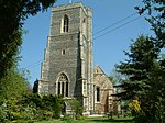 More images |
| Naze Tower | Walton-on-the-Naze, Frinton and Walton, Tendring | Navigational tower | 1720 | 21 June 1984 | TM2648623539 51°51′52″N 1°17′17″E / 51.864431°N 1.288113°E / 51.864431; 1.288113 (Naze Tower) | 1165846 | 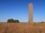 More images |
| The Homestead | Frinton on Sea, Frinton and Walton, Tendring | House | 1905-6 | 18 May 1979 | TM2335319396 51°49′43″N 1°14′24″E / 51.828503°N 1.240014°E / 51.828503; 1.240014 (The Homestead) | 1111531 |  More images |
| Copley Dene and Wall Attached to Left | Great Bromley, Tendring | House | Early/mid 18th century | 21 February 1950 | TM0846925427 51°53′18″N 1°01′41″E / 51.8884°N 1.027982°E / 51.8884; 1.027982 (Copley Dene and Wall Attached to Left) | 1147103 | Upload Photo |
| Church of All Saints | Dovercourt, Harwich, Tendring | Church | Medieval | 25 September 1951 | TM2383931102 51°56′00″N 1°15′17″E / 51.933387°N 1.254641°E / 51.933387; 1.254641 (Church of All Saints) | 1205059 | 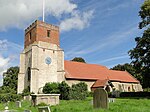 More images |
| Church of St Nicholas | Harwich, Tendring | Church | 1822 | 25 September 1951 | TM2611632584 51°56′45″N 1°17′19″E / 51.945769°N 1.288678°E / 51.945769; 1.288678 (Church of St Nicholas) | 1281276 | 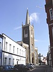 More images |
| Electric Palace Cinema | Harwich, Tendring | Cinema | 1911 | 18 September 1972 | TM2613232673 51°56′48″N 1°17′20″E / 51.946562°N 1.288969°E / 51.946562; 1.288969 (Electric Palace Cinema) | 1204934 | 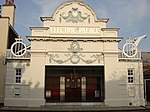 More images |
| High House | Harwich, Tendring | House | c. 1820 | 30 June 1964 | TM2615032541 51°56′43″N 1°17′21″E / 51.94537°N 1.289144°E / 51.94537; 1.289144 (High House) | 1204838 | Upload Photo |
| High Lighthouse | Harwich, Tendring | Lighthouse | Disused | 30 June 1964 | TM2611632438 51°56′40″N 1°17′19″E / 51.944459°N 1.288582°E / 51.944459; 1.288582 (High Lighthouse) | 1280598 | 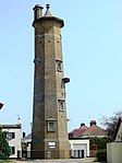 More images |
| No 26, Kings Head St. and Frontage Wall to South East | Harwich, Tendring | House | Late 16th century | 25 September 1951 | TM2595632764 51°56′51″N 1°17′11″E / 51.94745°N 1.286473°E / 51.94745; 1.286473 (No 26, Kings Head St. and Frontage Wall to South East) | 1281089 | Upload Photo |
| Old Naval Yard Crane | Harwich, Tendring | Crane | 1667 | 25 September 1951 | TM2621232468 51°56′41″N 1°17′24″E / 51.944689°N 1.289996°E / 51.944689; 1.289996 (Old Naval Yard Crane) | 1187899 |  More images |
| Redoubt | Harwich, Tendring | Moat | 1808-1810 | 20 June 1972 | TM2616432179 51°56′32″N 1°17′21″E / 51.942115°N 1.289109°E / 51.942115; 1.289109 (Redoubt) | 1187916 | 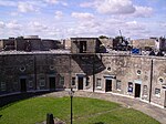 More images |
| The Old Swan House | Harwich, Tendring | House | 16th century | 25 September 1951 | TM2597232720 51°56′49″N 1°17′12″E / 51.947049°N 1.286676°E / 51.947049; 1.286676 (The Old Swan House) | 1281210 | Upload Photo |
| 10 King's Quay Street | Harwich, Tendring | House | Late 18th century | 20 June 1972 | TM2602932778 51°56′51″N 1°17′15″E / 51.947546°N 1.287542°E / 51.947546; 1.287542 (10 King's Quay Street) | 1187905 | Upload Photo |
| 34 and 35 Church Street | Harwich, Tendring | House | 17th century | 25 September 1951 | TM2592632710 51°56′49″N 1°17′10″E / 51.946977°N 1.286001°E / 51.946977; 1.286001 (34 and 35 Church Street) | 1187884 | Upload Photo |
| 42 and 42a Church Street | Harwich, Tendring | House | Mid 18th century | 25 September 1951 | TM2595532718 51°56′49″N 1°17′11″E / 51.947037°N 1.286428°E / 51.947037; 1.286428 (42 and 42a Church Street) | 1298480 | Upload Photo |
| Church of St Mary | Little Bromley, Tendring | Parish Church | Early 12th century | 17 November 1966 | TM0917527821 51°54′35″N 1°02′23″E / 51.909629°N 1.039677°E / 51.909629; 1.039677 (Church of St Mary) | 1337175 | 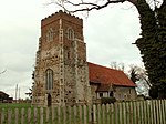 More images |
| Church of St James | Little Clacton, Tendring | Parish Church | Earlier than 14th century | 17 November 1966 | TM1661218820 51°49′34″N 1°08′31″E / 51.825984°N 1.141986°E / 51.825984; 1.141986 (Church of St James) | 1165915 |  More images |
| St Mary's House | Little Oakley, Tendring | House | 1987 | 30 January 1987 | TM2120928462 51°54′39″N 1°12′53″E / 51.910739°N 1.214755°E / 51.910739; 1.214755 (St Mary's House) | 1112098 | Upload Photo |
| Ramsey Windmill | Ramsey and Parkeston, Tendring | Windmill | 1842 | 29 April 1952 | TM2092130407 51°55′42″N 1°12′43″E / 51.928313°N 1.211822°E / 51.928313; 1.211822 (Ramsey Windmill) | 1147549 |  More images |
| Roydon Hall Farmhouse | Ramsey and Parkeston, Tendring | Jettied House | Late 16th century | 29 April 1952 | TM1896930206 51°55′38″N 1°11′00″E / 51.927279°N 1.18335°E / 51.927279; 1.18335 (Roydon Hall Farmhouse) | 1308521 | Upload Photo |
| White House Farmhouse | Ramsey and Parkeston, Tendring | Farmhouse | Mid 16th century | 30 January 1987 | TM2099030248 51°55′37″N 1°12′46″E / 51.926858°N 1.212721°E / 51.926858; 1.212721 (White House Farmhouse) | 1112106 | Upload Photo |
| Little Priory & the Old House | St Osyth, Tendring | House | c. 1530 | 29 April 1952 | TM1234315569 51°47′54″N 1°04′41″E / 51.798435°N 1.078143°E / 51.798435; 1.078143 (Little Priory & the Old House) | 1166252 | Upload Photo |
| St Osyth's Priory Outbuilding Adjacent to North of Dairy Qv 15/188 Now a Barn | St. Osyth, Tendring | Barn | Medieval | 21 February 1950 | TM1205715701 51°47′59″N 1°04′27″E / 51.799728°N 1.074082°E / 51.799728; 1.074082 (St Osyth's Priory Outbuilding Adjacent to North of Dairy Qv 15/188 Now a Barn) | 1166310 | Upload Photo |
| St Osyth's Priory Wall Between Southern Wing of Convalescent Home Qv 15/197 and Darcy Tower Qv 15/199 | St. Osyth, Tendring | Gate | 1987 | 21 February 1950 | TM1215515709 51°47′59″N 1°04′32″E / 51.799763°N 1.075506°E / 51.799763; 1.075506 (St Osyth's Priory Wall Between Southern Wing of Convalescent Home Qv 15/197 and Darcy Tower Qv 15/199) | 1111465 | Upload Photo |
| St Osyth's Priory boundary walls | St. Osyth, Tendring | Wall | Mainly 14th-17th century, possibly 12th century in origin | 21 February 1950 | TM1205915566 | 1337160 |  |
| Church of St Edmund | Tendring | Parish Church | 13th century | 17 November 1966 | TM1433724152 51°52′29″N 1°06′44″E / 51.87473°N 1.112328°E / 51.87473; 1.112328 (Church of St Edmund) | 1112122 | 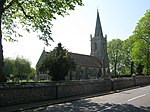 More images |
| Comarques | Thorpe-le-Soken, Tendring | House | Mid 18th century | 29 April 1952 | TM1748922640 51°51′36″N 1°09′26″E / 51.859937°N 1.157092°E / 51.859937; 1.157092 (Comarques) | 1112108 | Upload Photo |
| Parish Church of St Michael | Thorpe-le-Soken, Tendring | Church | 15th century | 30 January 1987 | TM1792922294 51°51′24″N 1°09′48″E / 51.85666°N 1.163254°E / 51.85666; 1.163254 (Parish Church of St Michael) | 1147716 | 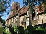 More images |
| The Abbey | Thorpe-le-Soken, Tendring | Jettied House | Mid 16th century | 29 April 1952 | TM1806422286 51°51′24″N 1°09′55″E / 51.856535°N 1.165206°E / 51.856535; 1.165206 (The Abbey) | 1322618 |  More images |
| The Bell Hotel | Thorpe-le-Soken, Tendring | Church House | c. 1500 | 29 April 1952 | TM1796822310 51°51′24″N 1°09′50″E / 51.856788°N 1.163829°E / 51.856788; 1.163829 (The Bell Hotel) | 1112112 | 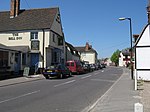 More images |
| Church of St Mary Magdelene | Thorrington, Tendring | Parish Church | Early 14th century | 17 November 1966 | TM0985819622 51°50′09″N 1°02′41″E / 51.835761°N 1.044612°E / 51.835761; 1.044612 (Church of St Mary Magdelene) | 1265150 | 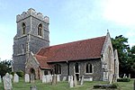 More images |
| Thorrington Tide Mill and Attached Dam Wall to North West | Thorrington, Tendring | Mill and Dam | 19th century | 29 April 1952 | TM0823419438 51°50′05″N 1°01′15″E / 51.834716°N 1.020965°E / 51.834716; 1.020965 (Thorrington Tide Mill and Attached Dam Wall to North West) | 1265152 | 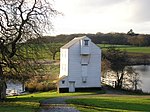 More images |
| Church of St Andrew | Weeley, Tendring | Parish Church | C15/C16 | 17 November 1966 | TM1541821528 51°51′03″N 1°07′35″E / 51.850757°N 1.126372°E / 51.850757; 1.126372 (Church of St Andrew) | 1265107 | 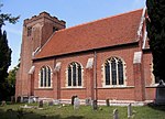 More images |
| Parish Church of All Saints | Wrabness, Tendring | Church | Early 12th century | 30 January 1987 | TM1742431889 51°56′35″N 1°09′43″E / 51.942992°N 1.161979°E / 51.942992; 1.161979 (Parish Church of All Saints) | 1112074 | 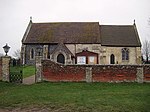 More images |
| Cann Hall | Tendring | House | 18th century | 4 July 1986 | TM1664416767 51°48′27″N 1°08′28″E / 51.807541°N 1.141167°E / 51.807541; 1.141167 (Cann Hall) | 1111549 | Upload Photo |
| Church of St James | Tendring | Church | 1912-12 | 5 March 1997 | TM1722114528 51°47′14″N 1°08′53″E / 51.787217°N 1.148122°E / 51.787217; 1.148122 (Church of St James) | 1257896 | 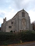 More images |
Notes
- ^ The date given is the date used by Historic England as significant for the initial building or that of an important part in the structure's description.
- ^ Sometimes known as OSGB36, the grid reference is based on the British national grid reference system used by the Ordnance Survey.
- ^ The "List Entry Number" is a unique number assigned to each listed building and scheduled monument by Historic England.
External links
- v
- t
- e
- Bedfordshire
- Berkshire
- Bristol
- Buckinghamshire
- Cambridgeshire
- Cheshire
- Cornwall
- Cumbria
- Derbyshire
- Devon
- Dorset
- Durham
- East Sussex
- East Riding of Yorkshire
- Essex
- Gloucestershire
- Greater London
- Greater Manchester
- Hampshire
- Herefordshire
- Hertfordshire
- Isle of Wight
- Kent
- Lancashire
- Leicestershire
- Lincolnshire
- Merseyside
- Norfolk
- North Yorkshire
- Northamptonshire
- Northumberland
- Nottinghamshire
- Oxfordshire
- Rutland
- Shropshire
- Somerset
- South Yorkshire
- Staffordshire
- Suffolk
- Surrey
- Tyne and Wear
- Warwickshire
- West Midlands
- West Sussex
- West Yorkshire
- Wiltshire
- Worcestershire
- Allerdale
- Amber Valley
- Ashford
- Babergh
- Barrow-in-Furness
- Basildon
- Basingstoke and Deane
- Bath and North East Somerset
- Bolsover
- Boston
- Bournemouth
- Bradford
- Braintree
- Breckland
- Brentwood
- Brighton and Hove
- Bristol
- Broadland
- Calderdale
- Cambridge
- Camden
- Canterbury
- Carlisle
- Castle Point
- Chelmsford
- Cheltenham
- Cherwell
- Cheshire East
- Cheshire West and Chester
- Chesterfield
- Chiltern
- Christchurch
- Colchester
- Copeland
- Corby
- Cotswold
- Dartford
- Daventry
- Dover
- East Cambridgeshire
- Exeter
- Mendip
- North Somerset
- North Yorkshire (district)
- Poole
- Sedgemoor
- South Somerset
- Stoke-on-Trent
- Taunton Deane
- West Somerset
- York


