Mata, Rio Grande do Sul
Place in South, Brazil

Flag

Seal

Location in Rio Grande do Sul, Brazil
(2020 [1])
Mata is a municipality in Rio Grande do Sul in Brazil.
Paleontology
The city of Mata has large deposits of petrified trees.
Museum of the city that have fossils:
- Museum Daniel Cargnin.
- Palaeobotanical Garden in Mata
-
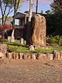
 Museum Daniel Cargnin
 -
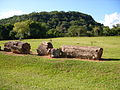 Petrified wood in the Paleobotanic Park
 -
 São Roque community
 -
 Petrified wood


References
- ^ IBGE 2020
External links
 Mata travel guide from Wikivoyage
- v
- t
- e

Capital: Porto Alegre
Mesoregion Centro Ocidental Rio-Grandense | |||||||
|---|---|---|---|---|---|---|---|
| |||||||

Mesoregion Metropolitana de Porto Alegre | |||||||||||||
|---|---|---|---|---|---|---|---|---|---|---|---|---|---|
| |||||||||||||
Mesoregion Nordeste Rio-Grandense | |||||||
|---|---|---|---|---|---|---|---|
| |||||||
Mesoregion Noroeste Rio-Grandense | |||||||||||||||||||||||||||
|---|---|---|---|---|---|---|---|---|---|---|---|---|---|---|---|---|---|---|---|---|---|---|---|---|---|---|---|
| |||||||||||||||||||||||||||
Mesoregion Sudeste Rio-Grandense | |||||||||
|---|---|---|---|---|---|---|---|---|---|
| |||||||||
Mesoregion Sudoeste Rio-Grandense | |||||||
|---|---|---|---|---|---|---|---|
| |||||||
Authority control databases | |
|---|---|
| International |
|
| National |
|
 | This geographical article relating to Rio Grande do Sul is a stub. You can help Wikipedia by expanding it. |
- v
- t
- e


