National Register of Historic Places listings in Bamberg County, South Carolina

This is a list of the National Register of Historic Places listings in Bamberg County, South Carolina.
This is intended to be a complete list of the properties and districts on the National Register of Historic Places in Bamberg County, South Carolina, United States. The locations of National Register properties and districts for which the latitude and longitude coordinates are included below, may be seen in a map.[1]
There are 12 properties and districts listed on the National Register in the county, including 1 National Historic Landmark.
This National Park Service list is complete through NPS recent listings posted June 14, 2024.[2]
Map all coordinates using OpenStreetMap
Download coordinates as:
- KML
- GPX (all coordinates)
- GPX (primary coordinates)
- GPX (secondary coordinates)
Current listings
| [3] | Name on the Register[4] | Image | Date listed[5] | Location | City or town | Description |
|---|---|---|---|---|---|---|
| 1 | American Telephone and Telegraph Company Building |  | July 8, 1999 (#99000815) | 124 N. Palmetto Ave. 33°19′36″N 81°08′31″W / 33.326667°N 81.141944°W / 33.326667; -81.141944 (American Telephone and Telegraph Company Building) | Denmark | |
| 2 | Bamberg City Hall | 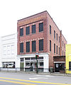 | September 28, 2005 (#05001099) | 3069 Main Highway 33°17′47″N 81°02′07″W / 33.296389°N 81.035278°W / 33.296389; -81.035278 (Bamberg City Hall) | Bamberg | |
| 3 | Bamberg Historic District |  | May 19, 1983 (#83002184) | E. Railroad Ave. and 2nd, Midway, Elm, Cannon, N. Carlisle, and Church Sts. 33°17′47″N 81°01′54″W / 33.2965°N 81.0316°W / 33.2965; -81.0316 (Bamberg Historic District) | Bamberg | |
| 4 | Bamberg Post Office |  | May 22, 2007 (#07000074) | 11955 Heritage Highway 33°17′47″N 81°02′02″W / 33.2964°N 81.0338°W / 33.2964; -81.0338 (Bamberg Post Office) | Bamberg | |
| 5 | Gen. Francis Marion Bamberg House |  | June 29, 1976 (#76001692) | N. Railroad Ave. and N. Carlisle St. 33°17′50″N 81°02′57″W / 33.297222°N 81.049167°W / 33.297222; -81.049167 (Gen. Francis Marion Bamberg House) | Bamberg | |
| 6 | Cal Smoak Site | Upload image | January 6, 1986 (#86000042) | Address Restricted | Bamberg | |
| 7 | Copeland House |  | October 18, 1991 (#91001494) | Secondary Road 389, 0.3 miles south of its junction with South Carolina Highway 64 33°05′43″N 81°02′47″W / 33.095278°N 81.046389°W / 33.095278; -81.046389 (Copeland House) | Ehrhardt | |
| 8 | Denmark High School |  | March 29, 2001 (#01000297) | N. Palmetto Ave. 33°19′42″N 81°08′26″W / 33.328333°N 81.140556°W / 33.328333; -81.140556 (Denmark High School) | Denmark | |
| 9 | Mizpah Methodist Church |  | December 13, 2000 (#00001531) | Junction of U.S. Route 301 and S-5-31 33°07′07″N 81°10′46″W / 33.1187°N 81.1794°W / 33.1187; -81.1794 (Mizpah Methodist Church) | Olar | |
| 10 | Rivers Bridge State Park |  | February 23, 1972 (#72001187) | 6 miles southwest of Ehrhardt 33°03′22″N 81°05′45″W / 33.056119°N 81.095949°W / 33.056119; -81.095949 (Rivers Bridge State Park) | Ehrhardt | |
| 11 | Voorhees College Historic District |  | January 21, 1982 (#82003830) | Voorhees College campus 33°18′23″N 81°07′42″W / 33.3063°N 81.1282°W / 33.3063; -81.1282 (Voorhees College Historic District) | Denmark | |
| 12 | Woodlands |  | November 11, 1971 (#71000742) | 3 miles south of Bamberg on U.S. Highway 78 33°17′27″N 80°55′53″W / 33.2909°N 80.9314°W / 33.2909; -80.9314 (Woodlands) | Bamberg |
See also
Wikimedia Commons has media related to National Register of Historic Places in Bamberg County, South Carolina.
- List of National Historic Landmarks in South Carolina
- National Register of Historic Places listings in South Carolina
References
- ^ The latitude and longitude information provided in this table was derived originally from the National Register Information System, which has been found to be fairly accurate for about 99% of listings. Some locations in this table may have been corrected to current GPS standards.
- ^ National Park Service, United States Department of the Interior, "National Register of Historic Places: Weekly List Actions", retrieved June 14, 2024.
- ^ Numbers represent an alphabetical ordering by significant words. Various colorings, defined here, differentiate National Historic Landmarks and historic districts from other NRHP buildings, structures, sites or objects.
- ^ "National Register Information System". National Register of Historic Places. National Park Service. March 13, 2009.
- ^ The eight-digit number below each date is the number assigned to each location in the National Register Information System database, which can be viewed by clicking the number.
- v
- t
- e

by county
- Abbeville
- Aiken
- Allendale
- Anderson
- Bamberg
- Barnwell
- Beaufort
- Berkeley
- Calhoun
- Charleston
- Cherokee
- Chester
- Chesterfield
- Clarendon
- Colleton
- Darlington
- Dillon
- Dorchester
- Edgefield
- Fairfield
- Florence
- Georgetown
- Greenville
- Greenwood
- Hampton
- Horry
- Jasper
- Kershaw
- Lancaster
- Laurens
- Lee
- Lexington
- Marion
- Marlboro
- McCormick
- Newberry
- Oconee
- Orangeburg
- Pickens
- Richland
- Saluda
- Spartanburg
- Sumter
- Union
- Williamsburg
- York


