National Register of Historic Places listings in Lee County, South Carolina

This is a list of the National Register of Historic Places listings in Lee County, South Carolina.
This is intended to be a complete list of the properties and districts on the National Register of Historic Places in Lee County, South Carolina, United States. The locations of National Register properties and districts for which the latitude and longitude coordinates are included below, may be seen in a map.[1]
There are 17 properties and districts listed on the National Register in the county. An additional property was once listed, but has since been removed.
This National Park Service list is complete through NPS recent listings posted June 14, 2024.[2]
Map all coordinates using OpenStreetMap
Download coordinates as:
- KML
- GPX (all coordinates)
- GPX (primary coordinates)
- GPX (secondary coordinates)
Current listings
| [3] | Name on the Register[4] | Image | Date listed[5] | Location | City or town | Description |
|---|---|---|---|---|---|---|
| 1 | Ashwood School Gymnasium and Auditorium |  | May 25, 2011 (#09000914) | 160 Ashwood School Rd. 34°06′28″N 80°18′59″W / 34.107778°N 80.316389°W / 34.107778; -80.316389 (Ashwood School Gymnasium and Auditorium) | Bishopville | |
| 2 | Bishopville Commercial Historic District | Upload image | January 9, 1986 (#86000052) | N. Main St. between W. Church and Cedar Ln. and along Cedar Ln. 34°13′07″N 80°14′48″W / 34.218611°N 80.246667°W / 34.218611; -80.246667 (Bishopville Commercial Historic District) | Bishopville | |
| 3 | James Carnes House |  | January 9, 1986 (#86000051) | 200 S. Main St. 34°13′00″N 80°15′07″W / 34.21656°N 80.2519°W / 34.21656; -80.2519 (James Carnes House) | Bishopville | |
| 4 | Dennis High School |  | January 26, 2005 (#04001565) | 410 W. Cedar Ln. 34°13′27″N 80°14′54″W / 34.22423°N 80.24846°W / 34.22423; -80.24846 (Dennis High School) | Bishopville | |
| 5 | Thomas Fraser House |  | January 9, 1986 (#86000050) | U.S. Route 15 34°12′37″N 80°15′47″W / 34.21014°N 80.26305°W / 34.21014; -80.26305 (Thomas Fraser House) | Bishopville | |
| 6 | William Apollos James House |  | October 6, 1999 (#99000200) | 208 N. Dennis Ave. 34°13′13″N 80°14′53″W / 34.22037°N 80.24792°W / 34.22037; -80.24792 (William Apollos James House) | Bishopville | |
| 7 | Lee County Courthouse | 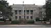 | October 30, 1981 (#81000568) | 123 S. Main St.[6] 34°13′02″N 80°14′58″W / 34.21711°N 80.24933°W / 34.21711; -80.24933 (Lee County Courthouse) | Bishopville | Built in 1908, designed by William Augustus Edwards |
| 8 | Lynchburg Presbyterian Church |  | October 1, 2004 (#04001088) | South Carolina Highway 341 34°03′18″N 80°03′59″W / 34.055°N 80.066389°W / 34.055; -80.066389 (Lynchburg Presbyterian Church) | South Lynchburg | |
| 9 | The Manor |  | January 9, 1986 (#86000049) | 529 N. Main St. 34°13′27″N 80°14′31″W / 34.22405°N 80.2419°W / 34.22405; -80.2419 (The Manor) | Bishopville | |
| 10 | Mt. Zion Presbyterian Church | 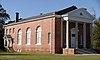 | July 17, 2003 (#03000661) | South Carolina Highway 154, St. Charles Rd. 34°06′02″N 80°13′42″W / 34.10056°N 80.22846°W / 34.10056; -80.22846 (Mt. Zion Presbyterian Church) | Bishopville | |
| 11 | Rembert Church |  | February 25, 1975 (#75001702) | 1 mile east of Woodrow on South Carolina Highway 37 34°05′51″N 80°21′11″W / 34.0975°N 80.353056°W / 34.0975; -80.353056 (Rembert Church) | Woodrow | |
| 12 | William Rogers House |  | January 9, 1986 (#86000047) | 531 W. Church St. 34°13′22″N 80°15′18″W / 34.22284°N 80.25487°W / 34.22284; -80.25487 (William Rogers House) | Bishopville | |
| 13 | St. Philip's Episcopal Church, Bradford Springs |  | April 17, 1996 (#96000406) | Bradford Springs Rd., approximately 6 miles north of Dalzell 34°06′13″N 80°25′33″W / 34.103611°N 80.425833°W / 34.103611; -80.425833 (St. Philip's Episcopal Church, Bradford Springs) | Dalzell | |
| 14 | South Main Historic District | Upload image | January 9, 1986 (#86000048) | S. Main between E. Harris and W. Ridge Sts. 34°12′51″N 80°15′14″W / 34.214167°N 80.253889°W / 34.214167; -80.253889 (South Main Historic District) | Bishopville | |
| 15 | Spencer House | 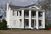 | January 9, 1986 (#86000046) | 817 N. Main St. 34°13′44″N 80°14′15″W / 34.22897°N 80.23747°W / 34.22897; -80.23747 (Spencer House) | Bishopville | |
| 16 | Tall Oaks | Upload image | January 9, 1986 (#86000045) | South Carolina Highway 341 34°13′35″N 80°15′38″W / 34.226389°N 80.260556°W / 34.226389; -80.260556 (Tall Oaks) | Bishopville | |
| 17 | Tanglewood Plantation | Upload image | September 22, 1977 (#77001229) | Southeast of Lynchburg on South Carolina Highway 341 34°01′55″N 80°01′14″W / 34.031944°N 80.020556°W / 34.031944; -80.020556 (Tanglewood Plantation) | Lynchburg |
Former listings
| [3] | Name on the Register | Image | Date listed | Date removed | Location | City or town | Description |
|---|---|---|---|---|---|---|---|
| 1 | Bishopville High School |  | October 1, 2004 (#04001087) | August 9, 2016 | 600 N. Main St. 34°13′26″N 80°14′26″W / 34.22383°N 80.24063°W / 34.22383; -80.24063 (Bishopville High School) | Bishopville | Torn down in 2016 by county, except for gymnasium and out-buildings added in the 1970's. |
See also
Wikimedia Commons has media related to National Register of Historic Places in Lee County, South Carolina.
- List of National Historic Landmarks in South Carolina
- National Register of Historic Places listings in South Carolina
References
- ^ The latitude and longitude information provided in this table was derived originally from the National Register Information System, which has been found to be fairly accurate for about 99% of listings. Some locations in this table may have been corrected to current GPS standards.
- ^ National Park Service, United States Department of the Interior, "National Register of Historic Places: Weekly List Actions", retrieved June 14, 2024.
- ^ a b Numbers represent an alphabetical ordering by significant words. Various colorings, defined here, differentiate National Historic Landmarks and historic districts from other NRHP buildings, structures, sites or objects.
- ^ "National Register Information System". National Register of Historic Places. National Park Service. March 13, 2009.
- ^ The eight-digit number below each date is the number assigned to each location in the National Register Information System database, which can be viewed by clicking the number.
- ^ Lee County Assessor's website. Retrieved 2013-02-18.
- v
- t
- e

by county
- Abbeville
- Aiken
- Allendale
- Anderson
- Bamberg
- Barnwell
- Beaufort
- Berkeley
- Calhoun
- Charleston
- Cherokee
- Chester
- Chesterfield
- Clarendon
- Colleton
- Darlington
- Dillon
- Dorchester
- Edgefield
- Fairfield
- Florence
- Georgetown
- Greenville
- Greenwood
- Hampton
- Horry
- Jasper
- Kershaw
- Lancaster
- Laurens
- Lee
- Lexington
- Marion
- Marlboro
- McCormick
- Newberry
- Oconee
- Orangeburg
- Pickens
- Richland
- Saluda
- Spartanburg
- Sumter
- Union
- Williamsburg
- York


